| Home | Sign up for Highlander Newsletter | Order Free Brochures and & More Info | Purchase Unique Gifts, Books, Photos & Artwork |
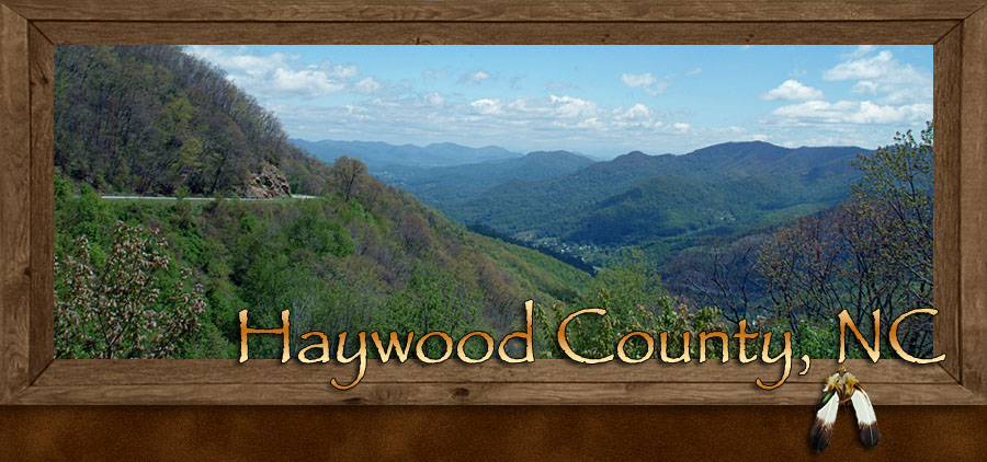
Haywood County Points of Interest and Scenic Drives
Haywood County and its neighboring mountain country include a wealth of beauty, history and wonders that will boggle the mind and capture your sense. Hidden away while in plain sight are vacation opportunities that you just can’t wait to experience and tell all your family and friends about, where you’ve been and what you have done. Man made and natural wonders await you at every turn, taking you to greater heights and into deep dark mysteries. Get ready for a journey into the land of plenty.
The Great Smoky Mountains National Park
The nation’s most popular National Park is on the very doorstep of Haywood County. The northeastern region of the national park reaches directly into Haywood County’s northwestern corner above Maggie Valley. It’s as though Haywood County had its own private entrance into the wilds and wonder of this world acclaimed biosphere. The Great Smoky Mountains 520,000 acres are protected under a national park status, preserving its woodland mountain treasures for all the generations to come.
Though the main doorway thru the National Park lies along the paved US 441, also known as the Newfound Gap Road, a scenic route that travels between the towns of Cherokee North Carolina and Gatlinburg Tennessee, the majority of the parklands are purposely concealed for preservation.
Haywood County has its own entryway into the National Park via the Cataloocheee Valley on the far eastern side of the park. This access road into the Great Smoky Mountains is not paved like the Newfound Gap Road; the gravel dirt forestry road is well maintained and used by many visitors who enjoy getting away from the so-called pave arena. This route into the park is for serious die-hard wilderness enthusiast, where as the paved Newfound Gap Road sees more than 10-million visitors a year.
It’s the campers, fishing persons, hikers, mountain bikers, equestrian and sightseers who journey into this end of the Great Smoky Mountains National Park. Horse lovers bring their own horses and trailers into this area of the park for that high country ride back in time. If you didn’t happen to pack a horse in your luggage, checkout a local stables on the edge of the park that offers guided horseback riding tours.
If you want to take a day trip and visit the heart and heights of the Great Smoky Mountains National Park while staying in Haywood County, via the hard pavement, I suggest the scenic driving tour along the Newfound Gap Road. You can access this scenic drive by taking US 441 north. Newfound Gap road begins at the northern border of town of Cherokee, North Carolina where the Qualla Boundary meets the Great Smoky Mountains National Park. Newfound Gap Road ends on the other side of the national park in Gatlinburg, Tennessee.
Qualla Boundary of the Cherokee

Legend tells it that they were the first to inhabit this mountain country some 10,000-years ago and the remaining Cherokee 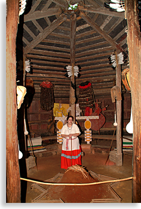 People, don’t intend on leaving any time soon, more like never.
The Qualla Boundary of the Eastern Band of the Cherokee lies at the southern gateway to the Great Smoky Mountains National Park in Western North Carolina along US 411 north.
Here you will find the indigenous people of the mountains, a world-class museum depicting their life history and a fairground complete with a covered outdoor stage for special events and festivals.
A large outdoors theater tucked away in an out of the way cove offers theatrical performances of the renowned Cherokee play “Unto these Hills.” The all-native Cherokee presentation is preformed nightly during its scheduled production season, telling the life story of the Cherokee People and their struggle to survive the odds, climaxing with the ill-fated “Trail of Tears”. Also next door to the outdoor theater is a full replica of a 1700’s Cherokee village, the Oconaluftee Indian Village where local Cherokee displaying customs, crafts and the traditions of their cherished nation. Don’t expect to see tee-pees here, the Cherokee are not a nomadic people, they lived in permanent structures.
While visiting the Qualla Boundary of the Cherokee if you’d like to invest in a game of chance, there’s a popular casino in the town of Cherokee both owned and operated by the tribal council of the Qualla Boundary.
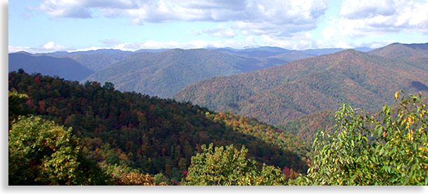
Shining Rock Wilderness Area
Two mountain river waterways, a modest lake, numerous waterfalls, and more hiking trials than you can shake a walking stick at reside along the great watershed of the northern face of the Balsam Mountains. Fly-fishing, camping, mountain biking, hiking, picnic areas and the infamous Cold Mountain rising out of the heart of the Shining Rock Wilderness Area. Breathtaking beauty and natural wonder barely describes this mountain wilderness of southern Haywood County.
The combined 26,400-acres of Shining Rock Wilderness Area along with the adjoining Middle Prong Wilderness’s of the Pisgah National Forest is an emerald paradise in the springtime and a palate of indescribable colors in the fall season. With Cold Mountain rising 6,030 feet out of the center and several of the Balsam Mountains peaks rising well over 6,000-foot, it has created a refuge for these two-wilderness area in Haywood County’s, Pisgah National Forest.
The beauty, majesty and popularity of this region are so obvious it is hard to image that this region was once considered “the land nobody wanted.”
Extensive logging in the early 1900’s devastated this land leaving it useless; the National Forest Service purchased the land in the 1930’s for restoration and preservation. Before this mountain region could be completely replenished, massive forest fires took their toll on these forest lands in the early 1940’s setting the timetable back even further. With reforesting and proper forest management the Shining Rock Wilderness Area today is a lush green paradise enjoyed by countless visitors each year and is part of the Forest Heritage National Scenic Byway driving tour.
Cataloochee Valley…A Historical Tour
Cataloochee Valley is isolated and a nearly lost to the world section of the northeastern mountainous region of the Great 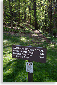 Smoky Mountains National Park. The name Cataloochee, is a Cherokee name, which means, “Wave upon wave of mountains.” In the late 19th and early 20th century the valley was once home to at least 1.200 residents who preferred to live in these remote, almost inaccessible mountains. Today, all that is left behind in this hidden valley are several old buildings, barns and homestead ruins; the current ranger station is located in one of the original rustic homes built in 1916. The Cataloochee Valley is only accessible by a gravel-dirt forestry road that can be reached by taking US 276 north from Dellwood in Haywood County, posted signs will lead you to the parks access road.
Visitors come and go along this forestry maintained route, yet its remote location keeps the numbers of travelers down to a minimum, just the way the parks preservation plan wants it to be, pristine and natural. The Cataloochee Primitive Campground has 27 campsites and there are 27-miles of hiking, biking and equestrian trails in the area. Horseback riding as well as mountain biking enthusiasts must transport their own mounts into the valley. Streams along this remote watershed are a favorite for fly-fishing.
The isolation of this region was the ideal choice for the park system’s Elk release in the 1990’s. The Elk were introduced to this wilderness area in order to assure their ability to thrive in a natural habitat in the wilds of the Great Smoky Mountains National Park. If you’re looking for a place to get away from it all and experience what was once a primitive state of America’s past, a visit to the Cataloochee Valley may be what you’re looking for.
Appalachian Trail
As the scenic Blue Ridge Parkway borders the southern edge of Haywood County, so does the infamous Appalachian Trails 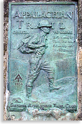 border the north edge of the county along the dividing of North Carolina to the south and the Tennessee Mountains and River Valley to the north.
This 2,160-mile hiking trail begins at Springer Mountain Georgia and ends in the upper eastern regions of the state of Maine’s Mount Katahdin, traversing 14 states in all along its nearly endless journey.
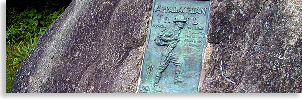
The Appalachian Trail travels northeast from Springer Mountain across the high ridges of the southern region of the Blue Ridge Mountains in North Georgia. Located near the southern access to the AT is a plaque commemorating the trail's early days. The plaque reads "Appalachian Trail" "Georgia to Maine" "A Footpath for Those who seek Fellowship with the Wilderness." "AT Brandmark 1934." The Trail then turns northward and crosses along the upper ridge tops of the Nantahala Mountains, arriving at the far southwestern end of the Smoky Mountains. The Appalachian Trail then follows the entire backbone ridge of the Great Smoky Mountains National Park and into the eastern regions of the national park that lies in the northeastern corner of Haywood County. The AT then crosses the Little Pigeon River at Interstate 40 then follows the northern edge of the Harmon Den Wildlife Area that borders Haywood County North Carolina and Cocke County Tennessee.
If you enjoy hiking and want a taste of this historic trail that found its beginning in 1920’s you can make that experience a reality by picking up the trail via Harmon Den Wilderness Area, accessible along Interstate 40. You can also pick up the Appalachian Trail at New Found Gap in the Great Smoky Mountains National Park.
Harmon Den Wildlife Area
In the far upper reaches of Haywood County is the Harmon Den Wildlife Area just off Interstate 40. There are no paved roads in the Harmon Den area though there are several trails into its interior. This region is popular for backpacking, hiking, mountain biking and equestrians who provide their own mounts and transport to the area.
This region, like most national forests was once logged to near extinction before it was purchased and returned to its near original state of existence with the help of the Civilian Conservation Corps in the 1940’s. The only camping available are primitive campsites.
Harmon Den got its name due to a hermit that once lived under a large rock outcropping on what later became known as Harmon Den Mountain.
Back to Haywood County
or
Take a Scenic Drive in Haywood County
Sign up for the Blue Ridge Highlander Newsletter, Messages from the Mountains
to find out first about our new feature stories, road trips and special offers
Your e-mail addresses will not be sold or given away to anyone.
Privacy Policy
Interested in your business being on the Highlander, click here...
Let our visitors tell you about the Highlander...
Click the feathers to go to the Highlander site
map...

Your e-mail addresses will not be sold or given away to anyone.
Let our visitors tell you about the Highlander...
Click the feathers to go to the Highlander site
map...
Highlander Special Interests
Great Mountain Attractions and Destinations Links to All Highlander Advertisers
Blue Ridge Highlander Mountain Emporium Art Gallery Photo Gallery Handmade Products Book Store
Magazine, Virtual Tours and Scenic Road Trips Creative Mountain Classes Just for Kids
Living Green and Eco Friendly in the Mountains Gardening in the Mountains Mountain Recipes
Mountain and Native American History Nathanael O. Smith - Storyteller Mysteries, Myths and Legends in the Mountains
Mountain Cathedral Charities and Fundraisers
Great Mountain Retreats
Adventure - Art - Cooking - Corporate - Family - Friend - Yoga - Wellness - Youth
Learn More About the Towns and Cities in the Mountains
North Georgia Mountains Western North Carolina Mountains
Up Country South Carolina Tennessee River Valley and Mountains
Great Smoky Mountains Blue Ridge Parkway
Move to or Invest in the Mountains
Real Estate - Log Homes - Cabins - Homes - Land - Acreage - Commercial Real Estate
North Georgia Mountain Real Estate Western North Carolina Real Estate
Tennessee River Valley and Smoky Mountain Real Estate
Traveling - Living - Enjoying the Mountains
Log Cabin Rentals - Vacation Rentals - Resorts - Condos - Inns - Hotels - Bed and Breakfasts
North Georgia Mountain Lodging Western North Carolina Lodging Tennessee River Valley Lodging
Plan a Mountain Wedding or Gatherings Conference, Meeting and Retreat Facilities
Vineyards - Wineries - Tasting Rooms Agri-Tourism Farmer's Markets
Yoga Retreats - Spas in the Mountains
Events and Festivals in the Mountains Theatre - Concerts - Mountain Entertainment
Restaurants, Dining and Catering in the Mountains
Shopping in the Mountains Blue Ridge Highlander Mountain Emporium and Art Gallery
Artists, Art Galleries and Art Associations in the Mountains Museums, History and Culture in the Mountains
Family Fun in the Mountains Just for Kids
Adventure and Outdoor Fun in the Mountains
Mountain Adventure Horseback Riding, Stables and Trails Mountain Bike Trails
White Water Rafting and Adventure Zipline - Canopy Tours Fishing in the Mountains
Boating and Marinas Camping and RV Parks ORV Adventures
Scenic Mountain Drives Mountain Golf Courses Mountain Day Use and Picnic Areas
National Parks in the Mountains National Forest Service in the Mountains State Parks in the Mountains
Waterfalls in the Mountains Lakes in the Mountains Rivers, Creeks and Trout Streams in the Mountains
Nature and Wildlife in the Mountains Mountain Birding Hiking Trails in the Mountains
More Information
Home Site Map Advertise on the Highlander Link to the Highlander Contact the Publisher
Legal Privacy Policy Copyright Policy
designed, produced and hosted by

of C. Wayne Dukes and Sherry Bell Dukes. 1996 - 2017, except where otherwise stated. All rights reserved, reproduction,
downloading, and/or duplication of any sort is strictly prohibited, all violations will be prosecuted. Legal Policy.
If you have any questions, or comments, regarding this site, e-mail the Highlander.