
story continued....
 As
we crest the south ridge of Pack Mountain, you'll see a wall of blue toned
mountains running north to south on the opposite side of an enormous plush
emerald green valley, this is Polk County, Tennessee. Polk County is a
historical county filled with mountains, lakes, whitewater rivers, a majestic
wilderness and a story that tells the tale of past land abuse, in the
name of progress and wealth. The green valley of upper Polk County is
coming back to life, as a results of a great reclamation plan organized
to restore life to a land devastated by acid rain, logging and copper
mining.
As
we crest the south ridge of Pack Mountain, you'll see a wall of blue toned
mountains running north to south on the opposite side of an enormous plush
emerald green valley, this is Polk County, Tennessee. Polk County is a
historical county filled with mountains, lakes, whitewater rivers, a majestic
wilderness and a story that tells the tale of past land abuse, in the
name of progress and wealth. The green valley of upper Polk County is
coming back to life, as a results of a great reclamation plan organized
to restore life to a land devastated by acid rain, logging and copper
mining.
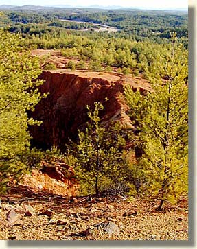
Prior to the 1850's The Copper Basin had already began to suffer due to the burning of forested land by both the early settlers and the Cherokee. Copper ore was discovered in this region in the 1850's. From the time of this discovery through 1987 the Copper Basin had the largest metal mining operation in the Southeastern United States. Early profiteers gave no attention to the environment, cutting down every available tree for copper smelting, creating an acid rain that killed over 60,000 acres. This turned the land into what was later described as having the appearance of a red moonscape.
 Several
large mines dot the landscape with Hiwassee Mine being the oldest, Isabella,
the Burra Burra Mine in Ducktown and the Company of Copperhill Tennessee.
Additional logging in the Cohutta Mountains made matters worse. The scars
are mostly hidden now, but the history of the mines is alive in the hearts
of the hearty mountain folk who did the back breaking labor in the mines,
and called their employer, "The Company."
Several
large mines dot the landscape with Hiwassee Mine being the oldest, Isabella,
the Burra Burra Mine in Ducktown and the Company of Copperhill Tennessee.
Additional logging in the Cohutta Mountains made matters worse. The scars
are mostly hidden now, but the history of the mines is alive in the hearts
of the hearty mountain folk who did the back breaking labor in the mines,
and called their employer, "The Company."
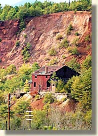
The US Forest Service purchased the devastated land, and a reclamation plan began with the help of the Civilian Conservation Corps in the early 1930's. It has continued through the efforts of at least three copper companies as well as the Tennessee Valley Authority. For more information, check out the The University of Tennessee Institute of Agriculture's "Copper Basin Reclamation Project."
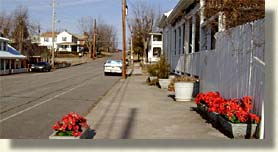
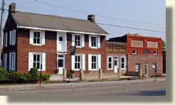
Two mining towns served the Copper Basin area, Ducktown and Copperhill. Copperhill, the larger town is located on the banks of the Ocoee River as it crosses into Tennessee. Across the state line adjoining Copperhill, is the North Georgia town of McCaysville. The Ocoee River becomes the Toccoa River once it crosses the Georgia state line . Copperhill is now a town of quaint shops, several eateries and lodging.
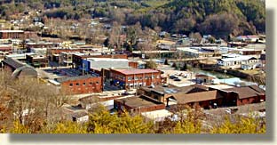
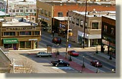
Both Copperhill and Ducktown are railroad towns serving the copper mines and logging industry. Ducktown is a classic mining town. The Burra Burra Mine site, on the edge of Ducktown is listed on the National Register of Historic Places. The Ducktown Basin Museum tells the story of this local mountain mining region.

It's the 1850's,so how do we get the copper to market? Transporting the heavy loads of copper, over what is now designated as a wilderness land of steep mountains, would be difficult to impossible. Down grades are the easiest way to the market and the Ocoee River Gorge was the only conceivable way down to the Tennessee River Valley below.
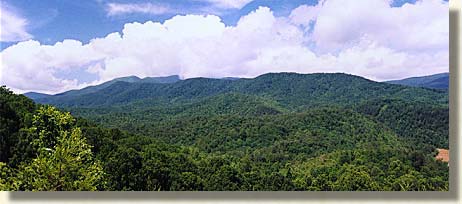
Continuing west on US 64 we approach the base of the Cohutta Mountains and begin a short climb to Boyd Gap, we have now entered the Cherokee National Forest of Eastern Tennessee. There's an overlook at Boyd Gap on the south side of US 64, although it is hard to notice without looking for it. From this overlook, you can see the grandeur of the Cohutta Mountain Wilderness northern region. Keep in mind, these mountains also suffered from the logger's saws at the turn of the century before the National Forest Service re-established these mountains to their present beauty. In the narrow valley below and to the west you can see the upper Ocoee River but don't necessarily be looking for water. The river is controlled by a system of dams. The water may not always be visible, but the multitude of large boulders forming the river bottom are.
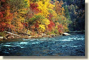
Following the Southern Highroads Trail on US 64 west, we make a descent into the natural and man-made wonders of the Ocoee River Gorge. The Ocoee River is a hard, forceful, natural, scenic whitewater river, whose water flow, and steep gorge seemed impossible to tame.
The original Ocoee River trail, became the Old Copper Road. This narrow trail following the Ocoee River had to be widened for freight going and coming into the Copper Basin Area, today we know this road as US 64, and a special part of the Southern Highroads Trail.
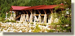 We've
now reach the northern bank of the Ocoee River and the Ocoee Whitewater
Center. The Ocoee Whitewater Center was built to host the 1996 Summer
Olympic Kayaking events. This is a great place for a break from driving.
This section of the river was constructed boulder by boulder to create
a course worthy of the Olympic games. The course only has whitewater flowing
through it on specified days between spring and fall, the main river is
diverted to the north. Low level water always flows through the course
creating wading pools along with small cascades amongst the numerous boulders,
throughout the visitor's area.
We've
now reach the northern bank of the Ocoee River and the Ocoee Whitewater
Center. The Ocoee Whitewater Center was built to host the 1996 Summer
Olympic Kayaking events. This is a great place for a break from driving.
This section of the river was constructed boulder by boulder to create
a course worthy of the Olympic games. The course only has whitewater flowing
through it on specified days between spring and fall, the main river is
diverted to the north. Low level water always flows through the course
creating wading pools along with small cascades amongst the numerous boulders,
throughout the visitor's area.
To the east of the Ocoee Whitewater Center, along the northern banks of the Ocoee River, is a section of the original Old Copper Road, it is now a well maintained trail. A hiking or trail bike trip along this trail you'll find a mostly level but rough and rocky trail with hand cut granite boulders, from one end of the Ocoee Gorge to the other. This example of early trail blazing makes an asphalt thoroughfare a welcome modern marvel of engineering.
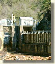
Leaving the Ocoee Whitewater Center and heading into the gorge, past a power station, round a big curve you'll reach a narrowing, steeper gorge and Ocoee Dam No. 2, the oldest of the Ocoee Dams. It's called the "wood dam" and it appears to be covered with a concrete type sealant. When the water flow is high, the dam works as a huge, thundering waterfall. On the opposite end of the dam are two flood gates, one opens onto the river below the dam, while the other gate flows into a wooden sluice or trough that follows high along the southern wall of the gorge.
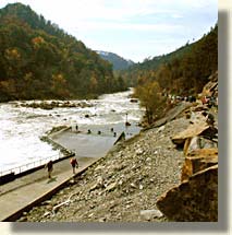
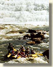
Ocoee Dam No. 2 is the middle Ocoee launch site for whitewater rafting and kayaking. These first rapids are rated a "class 5" for intensity, a quick learning experience for the novice adventurer. This set of rapids is rightfully known as, "Grumpys." Here we begin an exciting ride along the banks of the Ocoee River, under the shadows of a long wooden box filled with water.
The
Ocoee Gorge narrows with descent. The river below averages 5 to 12 feet
down from the 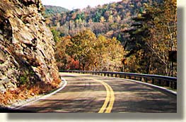 roads edge. There is no shoulder on the north side of the
road. Occasionally you can find a narrow pull off on the river bank side
of the road for whitewater viewers and photographers. Be careful if you
choose to pull off, and when you re-enter traffic, a lot of the road has
blind turns and it is hard to see what is coming around the bend.
roads edge. There is no shoulder on the north side of the
road. Occasionally you can find a narrow pull off on the river bank side
of the road for whitewater viewers and photographers. Be careful if you
choose to pull off, and when you re-enter traffic, a lot of the road has
blind turns and it is hard to see what is coming around the bend.
The thing I enjoy the most about the gorge is its accumulation of natural and man-made features. Nature created its force and beauty, man harnessed its power, making the gorge a melding of man and nature. The Old Copper Road and the Ocoee River are an exciting ride both on the road and on the river. The Ocoee River gorge is the only gorge on this journey where a road follows so closely to the whitewater, offering a constant view of the whitewater thrill. If you are interested in whitewater you'll enjoy the Blue Ridge Highlander's story, "Ancient Waters, Thrilling Ride".
Continuing down the Ocoee River Gorge
with the water-box hanging overhead, we come to an old stately brick powerhouse
that receives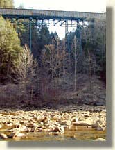 the pressure as the water in the box ends its journey, and dumps its load
back into the Ocoee River. After the power station, the Ocoee River begin
to level off, the perfect place to unload
the pressure as the water in the box ends its journey, and dumps its load
back into the Ocoee River. After the power station, the Ocoee River begin
to level off, the perfect place to unload 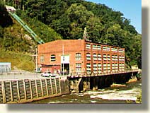 the
big air rafts for the journey back up the gorge. This where the rafting
enthusiast tell their tales and the rafting guides prepare to take another
group down the river. The trail down US 64 continues along gentle curves
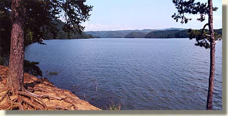
holding the river close in its grip, the now calm waters of the Ocoee
River begin to merge with the turquoise blue waters of Ocoee Lake as we
exit the gorge.
the
big air rafts for the journey back up the gorge. This where the rafting
enthusiast tell their tales and the rafting guides prepare to take another
group down the river. The trail down US 64 continues along gentle curves
holding the river close in its grip, the now calm waters of the Ocoee
River begin to merge with the turquoise blue waters of Ocoee Lake as we
exit the gorge.
Staying along the northern shores of Ocoee Lake, on US 64 we continue westward with Chilhowee Mountain rising sharply on the north side of the road. Ocoee Lake with its islands, channels and surrounding mountains is definitely a photo opportunity and has several overlooks along the lake's northern shore. Halfway between the gorge and Ocoee Dam No. 1 at the western end of the lake is a National Forest Ranger Station in the Cherokee National Forest. Here you'll find a steep paved road that will take you up to the top of Chilhowee Mountain with numerous views of Ocoee Lake, the Cohutta Wilderness and the Tennessee River Valley below.
Following the shores of Ocoee Lake we come to a low mountain gap between Chilhowee Mountain and a beautiful cone shape mountain of modest size to the southwest. Ocoee Dam No. 1 is situated in the center of this gap. There's a pull off here with an overview of the dam, and a diagram of the TVA's watershed control. Below the dam is a park of interest. Here you'll find a kiosk with a large embossed 3D display of the water shed of all the southern highlands Western and Eastern Continental Divide watersheds. This display really helps to understand the purpose in controlling the water flowing from the mountains. Another interesting feature in the park is a miniature model of the Ocoee Whitewater Center's Olympic Water Course. There's no water in the miniature model now, but during its development, water from the Ocoee River was diverted and used to test the miniature model's effect on boulder placement, it then diverted the testing waters back into the Ocoee River.

Exiting the park, US 64 continues west on the Southern Highroads Trail. At this point, a separate road veers north from the park on Polk County Road 314. This route cuts across the farmlands and meadows to Benton, Tennessee. Benton is a quaint farm community below the far western slopes of the Blue Ridge Mountains, located on a direct route leading to Knoxville Tennessee.
Polk County is a world of two lands, Upper Polk County and Lower Polk County. Upper Polk County is the land of high mountain wilderness, copper mining history, and the 18.8 mile John Muir Trail. The Hiwassee River, Conasauga River and the Ocoee River flow from Upper Polk County into Ocoee Lake and across the farmlands of Lower Polk County.
 The lower lands of Polk County and the
valley beyond has a cultural history older than the adjoining highlands.
This is part of the region known as the Tennessee River Valley. Over the
last 250 years, the valley's history evolved due to three main influences.
The first influence was the Native American and white settler conflicts
in the early expansion of America. The second was the the Civil War campaign
efforts to control the key southern city of Chattanooga and defeat the
Southern Army in the Battle of Atlanta. The third influence was the TVA's
construction of a network of dams and lakes, to control the flooding waters
from the Blue Ridge and Cumberland Mountains into the Tennessee River
Valley. This monumental task, was the work of the 1930's government project
known as the Tennessee
Valley Authority Watershed Control Project.
The lower lands of Polk County and the
valley beyond has a cultural history older than the adjoining highlands.
This is part of the region known as the Tennessee River Valley. Over the
last 250 years, the valley's history evolved due to three main influences.
The first influence was the Native American and white settler conflicts
in the early expansion of America. The second was the the Civil War campaign
efforts to control the key southern city of Chattanooga and defeat the
Southern Army in the Battle of Atlanta. The third influence was the TVA's
construction of a network of dams and lakes, to control the flooding waters
from the Blue Ridge and Cumberland Mountains into the Tennessee River
Valley. This monumental task, was the work of the 1930's government project
known as the Tennessee
Valley Authority Watershed Control Project.
![]()
Sign
up for the Blue Ridge Highlander Newsletter, Messages from the Mountains
to find out first about our new feature stories, road trips and special offers
Your e-mail addresses will not be sold or given away to anyone.
Privacy
Policy
Interested in your business being on the Highlander, click here...
Let our visitors tell you about the Highlander...
Click the feathers to go to the Highlander site
map...

Your e-mail addresses will not be sold or given away to anyone.
Let our visitors tell you about the Highlander...
Click the feathers to go to the Highlander site
map...
Highlander Special Interests
Great Mountain Attractions and Destinations Links to All Highlander Advertisers
Blue Ridge Highlander Mountain Emporium Art Gallery Photo Gallery Handmade Products Book Store
Magazine, Virtual Tours and Scenic Road Trips Creative Mountain Classes Just for Kids
Living Green and Eco Friendly in the Mountains Gardening in the Mountains Mountain Recipes
Mountain and Native American History Nathanael O. Smith - Storyteller Mysteries, Myths and Legends in the Mountains
Mountain Cathedral Charities and Fundraisers
Great Mountain Retreats
Adventure • Art • Cooking • Corporate • Family • Friend • Yoga • Wellness • Youth
Learn More About the Towns and Cities in the Mountains
North Georgia Mountains Western North Carolina Mountains
Up Country South Carolina Tennessee River Valley and Mountains
Great Smoky Mountains Blue Ridge Parkway
Move to or Invest in the Mountains
Real Estate • Log Homes • Cabins • Homes • Land • Acreage • Commercial Real Estate
North Georgia Mountain Real Estate Western North Carolina Real Estate
Tennessee River Valley and Smoky Mountain Real Estate
Interior Design and Furniture Shops Schools in the Mountains
Traveling • Living • Enjoying the Mountains
Log Cabin Rentals • Vacation Rentals • Resorts • Condos • Inns • Hotels • Bed and Breakfasts
Luxury Resorts and Spas in the Blue Ridge and Smoky Mountains
North Georgia Mountain Lodging Western North Carolina Lodging Tennessee River Valley Lodging
Plan a Mountain Wedding or Gatherings Conference, Meeting and Retreat Facilities
Vineyards • Wineries • Tasting Rooms Agri-Tourism Farmer's Markets
Yoga Retreats • Spas in the Mountains
Events and Festivals in the Mountains Theatre • Concerts • Mountain Entertainment
Restaurants, Dining and Catering in the Mountains
Shopping in the Mountains Blue Ridge Highlander Mountain Emporium and Art Gallery
Artists, Art Galleries and Art Associations in the Mountains Museums, History and Culture in the Mountains
Family Fun in the Mountains Just for Kids
Adventure and Outdoor Fun in the Mountains
Mountain Adventure Horseback Riding, Stables and Trails Mountain Bike Trails
White Water Rafting and Adventure Zipline • Canopy Tours Fishing in the Mountains
Boating and Marinas Camping and RV Parks ORV Adventures
Scenic Mountain Drives Mountain Golf Courses Mountain Day Use and Picnic Areas
National Parks in the Mountains National Forest Service in the Mountains State Parks in the Mountains
Waterfalls in the Mountains Lakes in the Mountains Rivers, Creeks and Trout Streams in the Mountains
Nature and Wildlife in the Mountains Mountain Birding Hiking Trails in the Mountains
More Information
Home Site Map Advertise on the Highlander Link to the Highlander Contact the Publisher
designed, produced and hosted by