| Home | Sign up for Highlander Newsletter | Order Free Brochures and & More Info | Purchase Unique Gifts, Books, Photos & Artwork |
| Cabin - Vacation Rentals |
Lake Resorts | Guided Fishing Trips | Residential & Commercial Builder | |
| Restaurants | Real Estate for Sale | Georgia Mtn Fairground Festivals and Super Star Concerts |
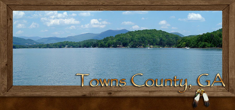
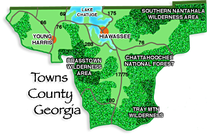
Hiawassee and Young Harris in Towns County North Georgia Mountains
Travel • Real Estate • Lodging • Restaurants • Georgia Mountain Fairgrounds • Outdoor Adventure
Mountain Top Georgia
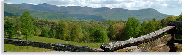
Founded in 1856, Towns County Georgia; is one of the most premier and beautiful mountain and valley settings in all the eastern United States. For those looking for the perfect getaway destination the county resides in what’s considered an ideal mountain atmosphere of mild weather, mountain fun, recreation, and leisure, offering a sense of rejuvenation with all the comforts of home.
The local towns of Hiawassee and Young Harris can provide all the necessary services to make your experience enjoyable, along with both indoor and outdoor recreation and entertainment. Within the heart of Towns County you’ll find mountains that embrace the skyline, lush green valleys, a large beautiful lake ideal for boating, swimming and fishing, a championship golf course, plus a variety of lodging from B & B's, Condos and Cabins to Hotels and premier Resorts. Whatever your choice, you can find it in Towns County.
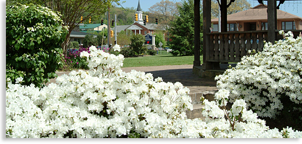
Fine dining and excellent eateries offer a variety of cuisine to satisfy anyone’s appetite, plus a local vineyard to test one’s personal palate. Towns County offers an outstanding selection of local specialty shops and galleries for those that would like to take a piece of the mountains back home with them or decorate their own mountain retreat. Live entertainment by famed headliners plus festivals and special events are a regular part of the fun at Towns County’s celebrated and historic Georgia Mountain Fairgrounds, ideally located along the shoreline of Lake Chatuge. Including an impressive garden display 3,000 Rhododendron plants, the largest collection in the State of Georgia
Part of North Georgia’s Chattahoochee National Forest makes up a large portion of Towns County offering opportunities for incredible outdoor recreation such as camping, hiking, scenic waterfalls, fishing, biking, horseback riding and scenic drives. This region of Chattahoochee National Forest in Towns County harbors a popular section of the renowned Appalachian Trail, great for a day, overnight or longer hikes. For those looking for more adventure there’s regional white water rafting, plus zip-lining and canopy tours only a short drive away.
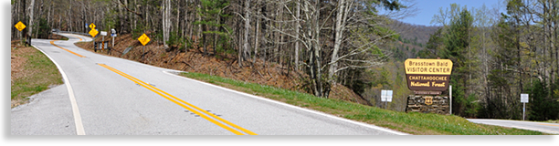
One of the many outstanding features in Towns County is Brasstown Bald and Wilderness Area, the highest point in the North Georgia Mountains and easily accessible by a paved roadway to the top. From the summit overlook, visitors can view the surrounding mountains, forest, valley lands and the glistening blue waters of Lake Chatuge in the valley below; this mountaintop site is virtually a stairway to the heavens.
Located in a low mountain gap along the western edge of Brasstown Valley is the mysterious Track Rock Archeological Area. This prehistoric site draws visitors annually to ponder the mysteries of its stone age carved boulders containing mostly indecipherable cryptic symbols of ancient Native American tales, tales of both myths and legends to those capable of understanding their meaning.
The natural beauty of Towns County is so captivating that the largest valley in the county is known as the Enchanted Valley. From the upper slopes along the Enchanted Valley one only has to gaze down upon the crystal blue waters of Lake Chatuge and realize they have found what they have always been looking for, a harmonious and exciting world within an exceptional landscape simply known as Towns County, North Georgia.
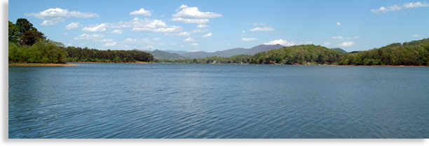
Lake Chatuge
Framed by towering mountains surrounding its distant shores and mirroring the blue skies above with its clear mountain waters, Lake Chatuge has all the aesthetics of a natural made wonder. Yet in contrast to its original unique setting, it’s the man-made lake that has transformed this once remote river valley in the central North Georgia Mountains into a water paradise for fun, recreation and beauty.
Lake Chatuge, constructed by the Tennessee Valley Authority (TVA) in the 1940’s for the purpose of flood control and utility power is one of the larger open bodies of water in the Blue Ridge Smoky Mountains region, with 128-miles of shoreline and an additional 4-miles of island shoreline. Lake Chatuge is divided at its center by the state lines of Towns County, Georgia and Clay County, North Carolina. Lake Chatuge consists of 3,500-acres in Towns County Georgia and 3,700-acres in Clay County North Carolina.
Where Lake Chatuge rests today was once a magnificent hidden valley dotted with homes, churches and family farms often located along or near the banks of the Hiwassee River. During the lake’s early construction it was necessary for homes, schools, churches and grave sites to be moved out of harms way or left to the destruction of the gathering river water and its many creeks and streams flowing down from the high mountains surrounding the lake. The upheaval of families was difficult for some of Towns County’s early residence and an opportunity for others looking for a fresh new start beyond the horizon.
Though the lake does operate under the management of TVA as a utility lake and flood control, the majority of the shoreline is privately owned and laced with picturesque summer homes and full time residences. Outside its natural beauty the lake’s most popular attraction is water recreation offering fishing, boating, sailing, skiing and jet skiing, along with swimming and sunning at its sandy beaches.
Camping in designated areas along the lake’s wooded shoreline is available along with excellent local or shoreline lodging. Several designated picnic areas and numerous boat launches plus two marinas are also available.
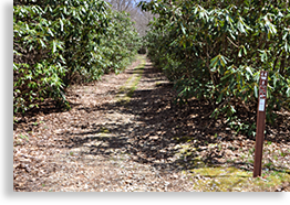
When it comes to hiking there are several quiet wilderness trails along the lake’s shoreline, as well as one trail that’s very popular with mountain bikers located Jackrabbit Mountain Recreation Area just north of the town of Hiawassee. Lake Chatuge Trail & Recreation Area offers the advantage of a low impact wooded shoreline trail. Then there’s the impressive low impact trail thru Hamilton Gardens located at the Georgia Mountain Fairgrounds, displaying an impressive 3,000 Rhododendron plants, the largest collection in the State of Georgia. The gardens are open free of charge most of the year with a small 3 dollar fee during the Rhododendron Blooming Season. There is a donation box available for maintaining the gardens by the local Lions Club for year round guests.
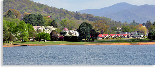
The resort town of Hiawassee located along the eastern shoreline of Lake Chatuge takes pride in accommodating all the comfort and needs for vacationing guest and local residents. The renowned Georgia Mountain Fair is also ideally located next to the town of
Hiawassee offering events, festivals, and live-entertainment at its Anderson Music Hall. There is also a museum depicting mountain
life, arts and crafts along with historical structures located in a wooded area within the fairgrounds as well as campsites and a boat launch ramp.
Today Lake Chatuge is a destination unto itself, drawing visitors annually to its shorelines and open waters. By far Lake Chatuge is a wonder in its making and a magnificent sight to behold and enjoy by folks of all ages.
Visitors can easily locate many of these opportunities along the shores of Lake Chatuge using the Highlander’s Mtn Top Georgia Mobile App.
Brasstown Valley
The picturesque Brasstown Valley and the Enchanted Valley of Lake Chatuge are two of the more incredible sites to behold in the Blue Ridge Smoky Mountains. Unlike the Enchanted Valley whose valley floor is mostly covered in lake water, Brasstown Valley is that perfect accent with a lush green valley floor and mountains towering above. It’s like having the best of both worlds in one package, with each valley conveniently divided along a mountain ridge with a low gap connecting the two valleys along US 76. Though relative by location they are visibly completely different yet one and the same when it comes to beauty and community spirit.
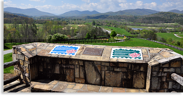
The Brasstown Valley Scenic Overlook along US 76 next to the golf course offers a birds-eye view of the historic valley. From the overlook low rolling hills flow northward across the valley with mountains rising along the distance horizon. To the south the great heights of Brasstown Bald, Georgia’s highest mountain towers high over the valley below.
Today Brasstown Valley is everything it should be for visitors looking for that perfect getaway. Low rolling hills along with open fields and meadows are dotted with homesteads and a few newer homes sprinkled across the landscape. Along the ridgeline to the east with great views of their own are a line vacation homes and full-time residences. The quaint college town of Young Harris lies just to the west of the overlook and a mountain vineyard lies off to the north. To the south an impressive mountain resort and championship golf course bearing the valleys name, rests along the lower slopes of the mighty Brasstown Range.
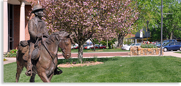
At the overlook there are several plaques depicting the natural and historic wealth of valley. One plaque tells of how cherished this valley homeland was and still is to the Cherokee people. While constructing the resort’s golf course, an extensive Native American village was uncovered calling for a temporary halt in construction. More than 400,000 artifacts were found causing the developer to redesign the golf course to respect, honor and preserve the history uncovered at this valley site. An exhibit and display of some of the artifacts including early mountain settler artifacts are located in the resort, sharing the Mountain Arts Association fine arts gallery. The gallery features fine artwork, selected by a juried committee and changed out seasonally. The gallery is open to the public free of charge.
Another fascinating archeological site also free of charge is located in a low mountain gap along the western edge of the valley, the Trackrock Archeological Area, famed for its ancient cryptic symbols carved on several large boulders.
Other points of interest in and around the Brasstown Valley can be located with the mobile App, including Cupid Falls at Corn Creek Preserve, a quiet picnic spot next to a waterfall, native plant garden area, picnic tables and short hiking trail.
Brasstown Valley in Towns County, Georgia is that great getaway destination if your looking for leisure strolls or longer challenging hikes, an observatory, a fine arts center and local fine arts gallery, horseback riding, a spa, golf, excellent lodging, fine dining and eateries and what some folks would refer to as having a front porch rocking chair with their name on it.
Towns County’s Towns and Communities
Hiawassee Georgia
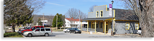
The town of Hiawassee in Towns County, Georgia is the only actual lake front town in the interior of the North Georgia Mountains. The town was originally incorporated in 1870 as Hiwassee, a Cherokee name for, “the river that flowed across the valley floor.” Later the town was re-incorporated as Hiawassee; the letter “a” was added to the name in 1956. Hiawassee is the county seat of Towns County. The original courthouse was completed in 1857 and replaced in 1905. The current courthouse located adjacent to the town square was constructed in 1964.
The town began to take on a different character than was originally intended when the Tennessee Valley Authority constructed the Chatuge Dam in the 1940’s creating the beautiful crystal sky blue waters of Lake Chatuge. The town of Hiawassee, which originally 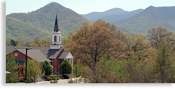 stood near the banks of the Hiwassee River, has since shaped itself along the eastern shoreline of the lake.
Overshadowing the town of Hiawassee along the southern mountain ridge is the towering summit of Brasstown Bald, marking the highest point in the North Georgia Mountains. Due to the town’s lake front mountain setting, Hiawassee has become an oasis to tourists, vacation homeowners and newly relocated folks looking for that special place of recreation and leisure living within a magnificent setting.
What you’ll find in the town of Hiawassee and neighboring areas are a nice selection of lodgings, fine dining and excellent eateries, galleries, specialty shopping, entertainment as well as indoor amusements.
If you’re looking for nearby outdoor adventure there’s camping, fishing, hiking, mountain biking, waterfalls both big and small, horseback riding, boating, skiing, swimming plus a championship golf course open to the public. If you’re an adventurous spirit looking for something more thrilling such as white water rafting, kayaking, guided fly fishing or zip-line-canopy tours you can find them within a short distance away by contacting tim@greatmountainadventures.com
Another premier advantage in Towns County is its own renowned Georgia Mountain Fairgrounds, a centerpiece for fun, entertainment and festivals along with Anderson Music Hall showcasing major headline talents, a museum and historic buildings and structures. The unique fairground setting cradles a section of Lake Chatuge’s shoreline.
The town of Hiawassee along the shores of beautiful Lake Chatuge is by far one of the most enjoyable, entertaining and rewarding destinations in the Blue Ridge Smoky Mountains.
Young Harris
Tucked away within the beautiful mountain valley setting of Brasstown Valley is the town of Young Harris, the second largest 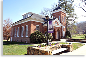 community in Towns County, Georgia. Quiet, charming, historical and educational are just a few words that epitomize the town of Young Harris. It’s one of those mountain towns that rolls-up the streets early, and is more tranquil in nature than what most people would expect from a small college town.
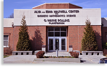
The town of Young Harris had its origins in the founding of Young Harris College established in 1886 as the McTyeire Institute, named after a Methodist Bishop Holland McTyeire. The school got its start when a local circuit riding Methodist minister Artemas Lester, saw the need for residents of the mountains to receive access to a more formal education. Isolated from the outer world during its formative years the college was placed in the hands of a local wealthy resident named Judge Young L.G. Harris. The judge kept the school going during the hard times of its early development. Today Young Harris College is an outstanding educational center within a stately college setting of both historic and more recent constructions. One historical campus structure cherished by the community is the 1892 Susan B. Harris Memorial Chapel.
A small local community of businesses providing services to the college and local residents began to develop along the roadway next to the school. Around 1894 people started to refer to the slow growing community as the town of Young Harris with the Young Harris College as the centerpiece of the community.
 Young Harris College is the home of the theatrical play and the official Georgia state historic drama, “The Reach of Song,” by poet Byron Reece. The play is performed at the college’s Clegg Fine Arts Center.
Another point of interest located on the campus is the O. Wayne Rollins Planetarium, a 109-seat capacity theater under a 40-foot-diameter dome. The planetarium features a GOTO Chronos Space Simulator star projector creating an immersive and engaging image over the entire dome surface. After the presentation at the planetarium ends and the night skies are clear, the Young Harris College Observatory located 1.5 miles from the campus will also be open to visitors.
The modest town of Young Harris offers visitors access to its wealth of history, culture, heritage, a premier resort with a 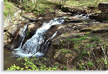 championship golf course, excellent lodging, cultural expressions, fine dining and local eateries, as well as miles and miles of hiking trails and horseback riding. Towering above all those options are Brasstown Bald Wilderness Area, featuring the tallest mountain and highest view in Georgia, overlooking Lake Chatuge, distant mountain ranges and in the valley below the mysterious Track Rock Archeological Area, a unique Native American archeological site for history buffs and curiosity hounds.
Located along the roadside behind the college is Cupid Falls at Corn Creek Preserves, an ideal setting and open to the public. Easy to access, Cupid Falls at Corn Creek Preserves is a quiet and tranquil picnic area next to the rushing waters of a waterfall. The preserve also has a native plant garden area, picnic tables and a short hiking trail.
Outside of young as well as seasoned minds being developed at the college, what draw the majority of visitors and new residents to the area is the mountain beauty and a sense of tranquility that the area has to offer.
Georgia Mountain Fairgrounds
& Historic Towns County
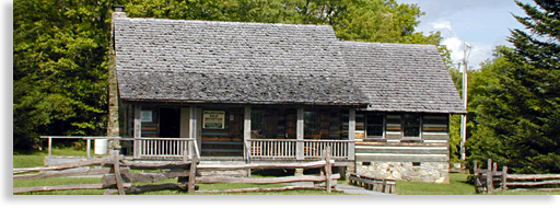
Located along a section of Lake Chatuge’s shoreline and centered within Towns County’s Georgia Mountain Fairgrounds is a historic village and fairway opened to the public during festivals and events. Within this historic village setting, visitors will also find a museum offering a wealth of historical exhibits, displays and mountain crafts. The historic structures throughout the village (intertwined with festival booths) come alive during festivals and events with live demonstrations of the arts, crafts and skills performed by mountain artisans. Here visitors will find historic cabins, a school house, a barn, an operating blacksmith shop, a working saw mill, a giant waterwheel and mill house, a smokehouse that is still in use and other significant historic structures, plus there’s an operating “moonshine still” demonstrating the making of distilled spirits practiced by their ancestors.
Each July the fairgrounds host the ever-popular “Georgia Mountain Fair,” a gala of everything a fair can be and much, much more. The fair features music, history, exhibits and demonstrations, as well as fairways of arts, crafts and food vendors with live entertainment both on the fairway and in the Anderson Music Hall. Plus there’s the annual Carnival and often-available live animal displays and a petting zoo that rounds out this two-week long summer event.
The Fall Festival is an explosion of color, fun and music that takes place each October, with artisans displaying their arts and crafts along with the Anderson Music Hall being packed to the rafters with guest, entertainers and groups performing throughout the day and into the evening. The Fall Festival is also features Georgia’s Official State Fiddlers' Convention.
|
The setting for these special events within and around the historic village lies under a shaded forest, a woodland village so hospitable you just can’t wait for the next fairground event. Only the ball fields where the carnival is held and parking area are mostly non-shaded.
One feature the fairground’s offers is the greater world of entertainment presented live at the Anderson Music Hall located at Georgia Mountain Fairgrounds. Throughout the year the fairgrounds host top name artist from Country Music’s award winning performers. This sizeable hall and stage seats 2,900 and is often sold out according to the greater popularity of the performing talent, so check out the Highlander’s event calendar and purchase your tickets early.
Also available at the fairgrounds and open to the public throughout the year is the Hamilton Gardens. These gardens along the wooded shoreline in a upper east corner of the fairgrounds contains one of the largest collections of hybrid Rhododendrons in the State of Georgia, blooming from early April to late May. The gardens are open with a minimal entrance fee of $3 during the blooming season and guided walking tours and shuttle tours are also available by appointment for a 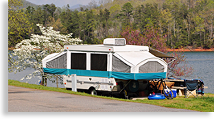 slightly higher fee. There is also a donation box available during the non-blooming days accepting donations for maintenance expenses by the local Lions Club that cherishes and preserves the garden for the public. The Garden is open from 9:00 am to 3:00 pm.
Another feature at the fairgrounds is its excellent campgrounds, public boat launch, tennis court, showers, electricity, telephone, cable service and adjacent public beach featuring a sand beach, bathhouse, playground, picnic pavilion and several bench swings. The beach is part of the park system and open free to the public.
Chattahoochee National Forest & the Great Outdoors
The Chattahoochee National Forest covers 749,549.71-acres of the mountainous high country of northern Georgia and is managed by several regional ranger district offices. The office serving the Towns County region is the Chattahoochee National Forest Office located to the west of the neighboring town of Blairsville.
High mountains, deep valleys and river gorges, rushing waterways, magnificent waterfalls, hardwood forest and native wildflowers, wildlife, camping, fishing, small hidden lakes, fish hatchery, scenic roadways, and miles upon miles of hiking and mountain biking trails; including a large southern most section of the renowned Appalachian Trail.
Counties within the mountainous regions of North Georgia average roughly a 50/50 ratio of public lands (which mostly include national forest and state parks) to privately owned properties throughout the counties. It’s this abundant ratio that offers so much wealth when it comes to enjoying the great outdoors for those visiting or living in the far southwestern Blue Ridge Mountains.
For more information concerning the great wealth of outdoor adventure, visitors can obtain maps and other materials concerning local hiking trails, biking trails, fishing areas, canoe and boat launches and camping areas at the local district office listed below.
District Ranger Station Serving the Towns County Area
Blue Ridge District Office:
2042 Highway 515 West Blairsville, Georgia 30512.
Phone: 706-745-6928.
Open Monday-Friday 8:00 a.m. to 4:30 p.m.
Closed 11:30 a.m. to 12:30 p.m.
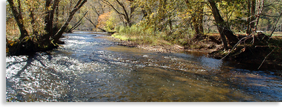
Hiwassee River
The Hiwassee River Basin contains one of the longest rivers in the southern Blue Ridge - Smoky Mountain Province. The river begins its headwaters along the northern slopes of Rocky Mountain in southern Towns County, Georgia. This often cascading river flows along its path northward before flowing into the waters of Lake Chatuge then continuing its journey westward across far western North Carolina, gathering its water twice more into the lake and channel waters of Lake Hiwassee and Lake Appalachia. From there the river crosses the southeastern Tennessee state line before exiting the mountains into the Great Tennessee River Valley below.
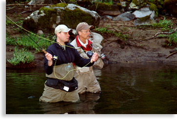 Though the Hiwassee River flows freely across the southern region of Towns County, and is both picturesque and ideal for fly-fishing, majorities of the river’s banks is along private property and not open to public fishing. You can have the opportunity to fish on these private sections of the river by booking a professional fishing guide, attending a private fishing campsite, or obtaining personal permission from property owners along the river. Whether you hire a pro or have permission to fish on your own, you must purchase a fishing permit.
Guides have access to the best spots and that’s what it’s all about. The good news is that once the river waters are gathered into the lake its pretty well open season for licensed fishing persons looking to cast their lines.
Convenient fishing along the lake’s shoreline where public access is available can be located at Jackrabbit Mountain Recreation Area or below the dam along TVA controlled property.
If you would like to book with a professional fishing guide for local fly-fishing or lake fishing, you can contact tim@greatmountainadventures.com
High Shoals Falls Scenic Area & Trail
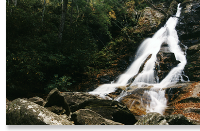 High Shoal Falls located in the far southern reaches of the Blue Ridge Mountains is likely the most spectacular and most visited waterfall in Towns County. The High Shoal Falls Scenic Area is 170 acres within the Chattahoochee National Forest. Within this region are cascading mountain creeks and streams, a hardwood forest, seasonal wildflowers, natural wildlife and an abundance of Mountain Laurel and Rhododendron often lining both sides of the trail for some distance at a time.
Though High Shoals Falls are beautiful to behold and 1.2-miles from the primitive parking area, it takes some effort to reach, mostly on the upgrade return trip to the parking area. Just past High Shoals Falls is its sister falls called the Blue Hole. The Blue Hole is made up of a series of five cascading waterfalls before reaching the 20-foot deep pool of the Blue Hole. High Shoals Falls itself is over 100-feet high pouring over jagged rocks often creating pockets of spraying water splashing off protruding rocks on its way down.
Access to High Shoals Falls Scenic Area is just off GA Highway 75 along the eastern side 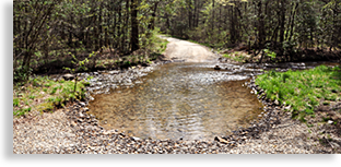 of the highway and marked by a small forestry road sign. As with many unpaved forestry roads the trip can be a little bouncy at times and includes a wide un-bridged creek bed that your vehicle can cross over near the beginning of the approach roadway to the upper trailhead. During rainy weather the creek bed can rise and the road can be muddy requiring the need of a four-wheel drive vehicle to cross the rain fed water current and to pull the muddy uphill grade. Never try to cross-strong water currents with your vehicle, strong currents can lift a vehicle off their wheels and float them down stream. During my first visit to the falls I used a standard size vehicle, the forestry road was dry and the creek was low, although the trip was a little bumpy in places. The creek does make a good family vehicle splashing photo or video opportunity.
Cupid Falls at Corn Creek Preserve
If you’re looking to visit a waterfall setting minus the forestry road and long hike, I recommend the Cupid Falls at Corn Creek Preserve. The falls are broad and about ten feet tall.
The Cupid falls is located conveniently alongside Thomastown Road near the southern edge of the town of Young Harris. The falls are as easy to view as looking out the windows of your horseless carriage. Cupid Falls at Corn Creed Preserve is located in a large 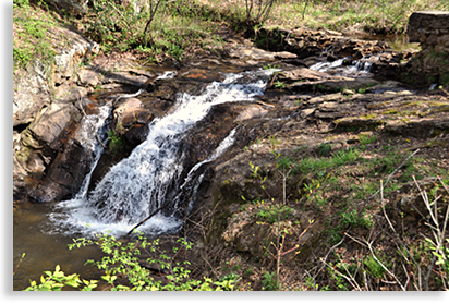 cove just behind Young Harris College, a beautiful park setting along the banks of Corn Creek.
Cupid Falls is the center piece of the park though it is only one part of a developing site called the “Children’s Interpretive Garden at Corn Creek Preserve. In its entirety the garden preserve will feature not only the falls, but also a short trail that crosses two footbridges and follows along both banks of the creek and natural gardens as well. The “Children’s Interpretive Garden at Corn Creek Preserve also features a tree house, a gazebo, several picnic tables and the marker for the old Corn Creek Mill site. The preserve’s gardens display and identify indigenous plants, medicinal plants, mosses, a butterfly garden and a small indigenous tree stand.
The waterfall is what captures the most attention with its ideal access next to the roadway for those looking for natural wonders in an easy to access area and easy to walk trail.
For a taste of the natural beauty of the waterfall the Blue Ridge Highlander has included in its Towns County Mobile App, a short video of the falls for our readers to enjoy, anywhere or anytime they need to take a break and get back to nature, even if it is only on a mobile phone or tablet.
Track Rock Archeological Area
Legends and folklore, mysteries and myths, science and speculation can’t completely explain the ancient encrypted carvings on large boulders located at the Track Rock Archeological Area.
The Track Rock Gap Archeological Area is in the heart of North Georgia’s Chattahoochee National Forest just below Brasstown Bald along Towns County’s western border. This archeological site lies in a low gap between two mountain ranges and is easily accessed by a paved roadway that travels along right next to the archeological site.
Trackrock Road, which passes over the gap next to the site, is part of an ancient trade route that travels north to south through the mountains. This site and trade route is estimated to have been in use since 1,000 A.D.; some speculate that the site and trade route are several thousands years older.
There are six major boulders at the site covered in encrypted carvings along with several other smaller stones scattered about the site that appear to have some type of carvings. These primitive carvings depict ancient symbols of human and animal forms along with what might be described as spirit beings. These carving were created at different times and not all at once, each set of carvings appears to tell a story or possibly a type of ritual.
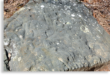 Whatever the mysteries at Track Rock Archeological Area are, is all up to speculation since the stones speak a language that archeologists as well as the native Cherokee haven’t been able decipher as of yet. Symbols may coincide with native legends yet their meanings are too uncertain. The Blue Ridge Highlander believes each visitor to the site can decide for themselves as to their nature and purpose.
What’s been newly added to the site is and interpretive area alongside the main boulders. What’s been removed from the site are the old protective grated cages that covered some of the larger boulders often obstructing the carvings though providing adequate protection from earlier vandalism and thief.
A feature story by the Blue Ridge Highlander concerning this site will find its way to its online magazine in the near future. This tale and other ancient tales of these regional mountains have many twists and turns to travel before attempting to unlock the mystery of the talking rocks and the spirit people the legends tell about.
Brasstown Bald - Wilderness Area and Trails
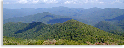
Brasstown Bald and Wilderness Area, located in the heart of North Georgia’s mountainous Chattahoochee National Forest has the highest unobstructed overlook in North Georgia, and is considered a virtual stairway to the heavens for visitors to the high country. Its mountain summit at 4,784-feet lies within the 12,975-acre Brasstown Bald Wilderness Area with breathtaking vistas reaching into the four states of the southern Blue Ridge Mountains. The good news is that the roadway to the mountaintop is paved.
 Located next to the Visitors’ Center near the summit of Brasstown Bald is a large paved parking area. The Visitors Center access to the summit is by way of a steep half-mile paved hiking trailhead that follows through a thick forest containing mountain laurels, rhododendrons, seasonal wildflowers and dwarfed trees. Also conveniently located near the summit’s trailhead is a shuttle bus that will take visitors to the top viewing area and return trip for a modest fee. Shuttle service is available daily from Memorial Day to the end of October.
Brasstown Bald is considered the crown jewel of North Georgia’s mountaintops. Balds exist mainly on the tallest mountaintops of the Blue Ridge - Smoky Mountains and are mostly void of any tall trees. These balds are normally covered in low shrubs, dwarf trees or tall grasses and are considered a mystery in their making. Both geologist and Cherokee folklore have their own separate ideas regarding the characteristics of balds and how they were formed.
On a clear day from Brasstown Balds circular 360-degree stone observation deck, located at the mountain summit, visitors can gaze upon Georgia’s mountainous high country and the neighboring mountains along the Eastern Tennessee border to the west. Looking eastward are the distance-mountains of Up Country South Carolina. Lining the horizon to the north, stand the towering mountains of Western North Carolina and the northern shoreline of Lake Chatuge in the valley below. Standing watch over the observation deck is an old circular wooden fire-lookout-tower that adds a personal sense of character to the balds’ summit and can be barely made out when viewed from the valley below; this structure is closed to the public.
Also located along the observation deck is a must see museum with excellent exhibits displaying the lives of early settlers, and a narrow gage locomotive used to maneuver steep mountain slope along a narrow gauge rail line. There are also exhibits of Native American culture, legends and myths along with displays of local wildlife. The museum also houses a small theater featuring a film of the natural geological history of this local mountainous region.
Other features located near the Visitor Center at the parking area below the summit, are three hiking trails, along with the trail that leads to the summit. A nearby boulder field surrounds most of the bald and is accessible from the trail. The mountaintop parking area has a flourishing amount of mountain laurels and rhododendrons that are native to the Blue Ridge Mountains. A list and access to these trails are listed below.
On occasions, the Visitor Center host special events that are quite an experience to enjoy since these festivities take place on an actual mountaintop. Information for these past and future events can be obtained at the local Chattahoochee National Forest District Office.
Inexperienced hikers as well as experienced hikers should never hike alone. It’s highly recommended to bring along a companion, drinking water and some energy bars or other manageable snacks for a day hike. As a courtesy always pack out what you bring in and leave the least amount of footprint (human impression) as possible allowing others to enjoy the same unique experience as you have enjoyed.
Brasstown Bald and Wilderness Area in Towns County Georgia is an outdoor experience that says it all; it is magnificent, indescribable and awe-inspiring.
Brasstown Bald Summit Trail
 There are two ways one can reach the upper summit of Brasstown Bald. From the parking area you can either take a comfortable shuttle trip to the top when the shuttle is operating from Memorial Day thru the end of October, or you can hike the better than half-mile trail to the top. The shuttle trip does require a modest fee.
The Brasstown Bald Summit Trail is located next to the Visitor Center (housed in a cabin), and is paved to the top. Though inviting at first glance the trail becomes quite steep once the getting gets going. The good news is the downhill trip is easier on the lungs and leg muscles although harder on the knees. I recommend a good walking stick to lean on along the way up and extra bracing for the way back down.
Wagon Train Trail
Accessible from the summit parking area at Brasstown Bald, this 5.6-mile trail follows along a wide pathway that was originally intended to be a part of GA Highway 66 (or 68, the research information might be a little cloudy.) The trailhead is a little tricky to find at first, to reach the trailhead hikers will need to follow the Brasstown Bald Summit Trail for about 100-yards. The Wagon Train Trail is located on the right marked by a plaque.
 The stress rating for this trail is moderate to strenuous depending on if your going up or down the mountain. The trail either finishes or begins in the valley below just 2 miles south of the town of Young Harris GA.
Even though the trail offers a grade suitable for a roadway I would recommend hiking the trail from top to bottom for a more enjoyable experience providing you have an extra vehicle waiting for you at the trails end. The trail offers great views especially in early spring or late autumn when views are less obstructed by leaves. The trail also follows past cliff formations and through upper boulder fields featuring rock tripe, lichens, club moss, reindeer moss and old man’s beard.
Season wildflowers such as mountain buttercups, white and purple violets, four varieties of trillium and other wildflower plants, line the forest trail.
Originally, local residents from the valley below used the Wagon Train Trail for annual excursions. The trail is wide due to the fact it was planned as a roadway. After the plan was canceled the trial became a means of holding onto the past for the local descendents of the original hardy mountain pioneers. Their quest to the mountaintop offered a sense of community spirit that stills echoes along the trail.
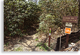
Arkaqua Trail
This 5.5-mile trail descends westward along a ridge top to the valley below and is either accessible from the back end of the summit parking area atop Brasstown Bald, or across the road from the Track Rock Archeological Area along Track Rock Road just off US 76 in the valley below.
 Hikers along the trail will pass through a northern hardwood forest while viewing scenic outbreaks through the trees, plus wildflowers and various herbs on their way to the Blue Bluff Overlook.
Along the way hikers will pass Chimney Top Mountain and be able to view Rocky Knob to the south. The stress rating for the trail is moderate to strenuous and not recommend for casual hikers. For most hikers that choose to take on the trail, I personally recommend the descent from the Brasstown Bald mountaintop parking area to the Track Rock Valley below providing you have someone drop you off at the top of the trail, and pick you up at the bottom of the trail or have a parked vehicle awaiting you at the end of your hike.
Jack’s Knob Trail
This 4.5-mile trail is accessible from the Brasstown Bald parking area at the top of the mountain or at the entrance to the Brasstown Bald Wilderness Area next to GA Highway 180.
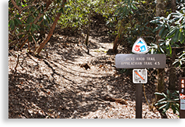 The trip up to the top from the lower entrance is only half the distance since the trail crosses GA Highway 180 before continuing on to where it connects to the Appalachian Trail to the south. The upper trailhead is located directly across the parking area from the Visitor Center as you enter the parking area. The ideal hike would be to bring two vehicles leaving one at the entrance parking area and the other at the mountaintop parking area and begin your journey from the top down. It’s an incredible journey and enjoyable accomplishment if one chooses to hike Jack’s Knob Trail both ways.
Jack’s Knob Trail was originally constructed in the 1930’s by the Civilian Conservation Corps, and then reconstructed by the Chattahoochee Forest Service in the 1980’s. The trail is rated moderate to strenuous as it follows southward along a ridgeline dividing the boundary between Towns and Union County. The trail continues along the ridge just west of and parallel to the ascending paved roadway to the summit of Brasstown Bald. The trail crosses GA Highway 180 at Jack’s Gap then continues on to the Chattahoochee Gap where it accesses the Appalachian Trail.
Appalachian Trail
You can say that the Appalachian Trail either begins or ends in the Blue Ridge Mountains of North Georgia depending on where one begins their journey. Stretching over 2,100-miles from Georgia’s Springer Mountain to Mount Katahdin in Maine, the Appalachian Trail is world-renowned to serious hikers and backpackers as well as day hikers looking for fresh air, exercise and outstanding mountain views.
The trail’s grand vision began in 1921 by forester, regional planner and conservationist Benton MacKaye, and completed in the Georgia region in 1931. A section of the trail’s most outstanding views stretch across the southern regions of Towns County, offering hikers the opportunity for a causal day’s hike, or overnight campouts for backpackers looking to escape the world below for an experience to remember in the natural world.
The Appalachian Trail has several access points within Towns County, listed in the points of interest points below are 3 of these access trails.
Available on the Blue Ridge Highlander’s, Mtn Top Georgia Mobile App, are three GPS locations where hikers can access the Appalachian Trail in southern Towns County Georgia. Two of these locations are at Unicoi Gap and Dicks Creek Gap where hikers will find convenient parking for immediate access to the trail. One other access point to the to the Appalachian Trail is via a hike along a section of Jack’s Knob Trail which hikers can pick up just across the roadway to the entrance to Brasstown Bald and Wilderness Area. There’s a parking area near the entrance to Brasstown Bald for hikers to use.
There are other trails in southern Towns County that can access the Appalachian Trail not contained in the points of interest listed below. We hope to make these available to hikers at a future date.
Appalachian Trail at Unicoi Gap
Unicoi Gap is located along GA Highway 75/2 high above the far southern reaches of Towns County. This is a perfect access point for day 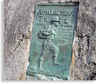 hikers or overnight backpackers looking to experience the wonders and beauty of the southern Blue Ridge Mountains along the renowned Appalachian Trail.
The spacious parking area at Unicoi Gap is located on the eastern side of highway. One of the more notable features at this access point along the Appalachian Trail is an old green tarnished bronze plaque imbedded in a large boulder with an embossed figure of a hiker dating back to 1934. The plaque commemorates the Georgia Appalachian Trail Club that manages and maintains Georgia’s 75.6-mile portion of the trail. An inspiring message on the plaque reads, “A Footpath for Those who seek Fellowship with the Wilderness.”
Whether your looking for a backpacking trip across the mountain tops, a days hiking tour or just a quick one-hour in and out experience along the Appalachian Trail its well worth the journey and the claim that you also hiked the infamous trail.
Appalachian Trail at Dicks Creek Gap
Dicks Gap is located along GA Highway 76/2 high above the far eastern reaches of Towns County and is a perfect access point for day hikers or overnight backpackers looking to experience the wonders and beauty of the southern Blue Ridge Mountain’s along the renowned Appalachian Trail.
The spacious parking area and access to the trail at Dicks Creek Gap is located on the northern side of highway. One of the more 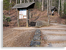 notable features at this access point to the Appalachian Trail is its tranquil beauty and setting within a hardwood forest.
This trail access site also offers a couple of kiosks providing hikers with valuable 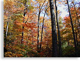 information for their journey. Also located at the site are several picnic tables for hikers or folks that are just looking for a roadside setting in a peaceful and beautiful environment. The leaf color here during the autumn season is exceptional.
Whether your looking for a backpacking trip across the mountain tops, a days hiking tour or just a quick one-hour in and out experience along the Appalachian Trail its well worth the journey.
Like many highway access points to the Appalachian Trail there is a large boulder at the trailhead with the trail access name and compass directions carved into a large boulder. It’s a good spot for a personalized photo opportunity before setting out on the trail.
Appalachian Trail via Jack’s Knob Trail
Located along GA Highway 180 adjacent to the entrance to Brasstown Bald is the halfway point along Jack’s Knob Trail that begins atop of Brasstown Bald and concludes at the Appalachian Trail at Chattahoochee Gap, approximately 2-miles to the south of GA Highway 180. Jack’s Knob Trail is rated moderate to strenuous.
Though the trail is conveniently located across from the entrance to Brasstown Bald, it is a little difficult to see at first. The trail beings on the south side of GA Highway 180 and instead of boldly opening into the woods, the trail runs parallel along the roadway before turning south, a marker is near the entrance to the trail visible when looking westward.
From this access point that leads to the Appalachian Trail, Jack’s Knob Trail begins as a long ascent before reaching a descent along a ridge trail, then a second ascent to the Appalachian Trail above. There is a convenient parking area next to the entrance to the Brasstown Bald and Wilderness Area for hikers.
Jackrabbit Mountain Recreation Area
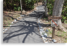
Located along the eastern shoreline of Lake Chatuge just north of the town of Hiawassee is Jackrabbit Mountain Recreation Area. This area is maintained by the National Forest offering designated areas for 103-camping sites, picnic areas, a swimming beach with showers, fishing deck, a boat launch ramp, a hiking and a very popular biking trail.
The Jackrabbit Mountain Trail is a loop within a loop, hiking trail. The outer loop trail is 2-miles long; the inner loop trail is 1.2-miles long.
The popular Jackrabbit Mountain Biking Trail is roughly 13-miles of various loops challenging riders of various strengths and skills. The biking trails are located on a peninsula surrounded by Lake Chatuge.
Also popular within the Jackrabbit Mountain Recreation Area are paved roadways for those bikers that prefer a more gentle bike ride along a more level and smoother terrain.
The Jackrabbit Mountain Recreation Area is open May 1 – September 30, though both the hiking and biking trails are open throughout the year.
Scenic Driving Tours
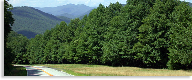
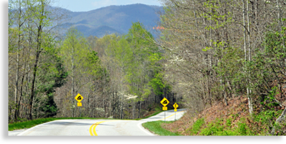
You could say most mountain roads and scenic byways are often one and the same to roadway armrest enthusiast. Yet when you get to know the natural landscape, you start picking cherries by means of mountain views and natural wonders. Designated scenic byways and driving tours can consolidate these wonders into an organized road trip that will get you the most bang out of your driving adventure budget, and bring you into contact with the hidden treasures that lay within the mountains natural beauty. Listed in the points of interest below are two favored road tours with one tour passing through Towns County from one end to another (east to west), and a second road trip that loops the fringes of three counties taking advantage of neighboring wonders and well as Towns County’s own natural wonders.
Southern Highroads Trail
This scenic drive (don’t let the word “Trail” fool you); is a section of the Southern Highroads Trail that passes thru Towns County along US 76 from one end of the county to the other from east to west, or vise-versa. The entire scenic roadway tour is a 364-mile loop drive. The trip across Towns County is roughly 30-miles, beginning at one mountain gap and ending at another.
 The Southern Highroads Trail travels its entire loop across North Georgia, then onto a shorter section of Up Country South Carolina, then across far southwestern North Carolina to a shorter section of southeastern Tennessee before reconnecting back in Georgia.
The Southern Highroads Trail crosses mountain gaps and valley floors, traveling through narrow gorges along rushing white-water rivers. All the while journeying thru historic towns and beautiful countryside.
Whether you prefer to take the short scenic drive thru the heart of Towns County or the longer trip along the Southern Highroads Trail, this scenic route offers some of the most beautiful mountain and valley areas in the southern Blue Ridge Mountains.
While traveling thru Towns County, surveying sights for our Blue Ridge Highlander’s, Mtn Top Georgia Mobile App, Mrs. Highlander and I recently witness famed actor, director and academy award winner, Clint Eastwood, filming a scene for his movie “Trouble with the Curve.” The filming was of a road scene that was along a section of the Southern Highroads Trail in eastern Towns County. We saw Clint, sitting in a late model convertible sports car behind a filming truck, he sat up on the back of the sports car seat and was giving direction to the cameraman. In another scene, we watched the film crew temporarily posting a North Carolina State sign along the roadside. The backdrop was western Towns County’s Upper Hightower region of North Georgia, not North Carolina...that’s Hollywood.
Russell Brasstown Scenic Byway
Located in the southern mountainous regions of Towns County’s Blue Ridge Mountains, and forming a scenic drive loop is the Russell Brasstown Scenic Byway.
In my personal opinion this is a four star, 40.6-mile, 360-degree view of what the wilderness lands of central North Georgia’s Chattahoochee National Forest, has to offer in all its glory. Tall mountains with endless vistas, rushing creeks and waterways, an abundance of waterfalls, miles and miles of hiking trails including the southern most section of the Appalachian Trail. Camping, biking, fly fishing, picnics, natural wildlife, and wildflowers all reside in a land where mysterious ancient Native American legends of other 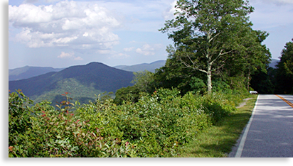 worldly beings tell their tales and show their wares in a mountain setting like none other.
The Russell Brasstown Scenic Byway takes in more natural wonders per mile than any other scenic route in North Georgia. This route will take visitors from the depths of the valleys to the heights of the tallest most accessible mountain in Georgia. Though beautiful to behold, the steep climbs and descents along the routes paved 2-lane and often 3-lane roadways, can be a little intimidating to some inexperienced mountain drivers. Yet it’s a paradise roadway to others that are familiar with the curves and up and downs of mountain highways.
For those with less mountain driving skills, its advised to take your time, pull over when you can do so safely, so that you can see the sights or just let the pushy traffic behind you pass you by. Also when going down steep slopes its sometime advisable to take the transmission gear shift out of over-drive, and place it into drive or second gear to avoid excessive brake usage. Also, don’t let your vehicle exceed the speed limit to avoid constant braking. A couple of trips over the mountain and you’ll soon be a local pro-driver of skill, or at least more experienced.
This 40.6-mile scenic drive follows four roadways creating a loop. These four roadways are the GA Highway 17/75 to ALT 75, GA Highway 348 to GA Highway 180, plus the access roadway to the top of Brasstown Bald just off of GA Highway 180. Please drive safely and have a great time.
| Lake Chatuge | Waterfalls in Towns County | Rivers, Creeks and Streams |
| Hiking in Towns County | Fishing in Towns County | Campgrounds in Towns County |
| Chattahoochee National Forest |
click map |
Hiawassee, Georgia Weather.com
Hiawassee • Young Harris • Towns County • North Georgia Mountains
| Georgia Mountain Fairground Festivals and Super Star Concerts | |||||
|
Go Directly to our web site.....GeorgiaMountainFairgrounds.com |
|||||
| Real Estate | |||||
| Residential and Commercial Builder | |||||
Tighe White Construction, Residential and Commercial Builder |
|||||
| Restaurants in Hiawassee | |||||
 |
The Chophouse of Hiawassee across from Lake Chatuge The Chophouse of Hiawassee is a welcome addition to Hiawassee's “restaurant scene”; it is one of Hiawassee's most exciting restaurants in North Georgia. The Chophouse features the finest in gourmet cuisine along with a million dollar view of Lake Chatuge. Featuring the finest in gourmet cuisine with casual indoor and outdoor dining (season permitting). 625 Highway 76 W • Hiawassee, GA 30546 • 706.896.3200 |
||||
|
|||||
| Cabin Rentals, Vacation Rentals, Lodging Hiawassee • Young Harris • Lake Chatuge • Towns County • North Georgia Mountains |
|||||
| Guided Fishing Trips on the Hiwassee River and Lake Chatuge | |||||
![]()
Sign up for the Blue Ridge Highlander Newsletter, Messages from the Mountains
to find out first about our new feature stories, road trips and special offers
Your e-mail addresses will not be sold or given away to anyone.
Privacy
Policy
Interested in your business being on the Highlander, click here...
Let our visitors tell you about the Highlander...
Click the feathers to go to the Highlander site
map...

Your e-mail addresses will not be sold or given away to anyone.
Let our visitors tell you about the Highlander...
Click the feathers to go to the Highlander site
map...
Highlander Special Interests
Great Mountain Attractions and Destinations Links to All Highlander Advertisers
Blue Ridge Highlander Mountain Emporium Art Gallery Photo Gallery Handmade Products Book Store
Magazine, Virtual Tours and Scenic Road Trips Creative Mountain Classes Just for Kids
Living Green and Eco Friendly in the Mountains Gardening in the Mountains Mountain Recipes
Mountain and Native American History Nathanael O. Smith - Storyteller Mysteries, Myths and Legends in the Mountains
Mountain Cathedral Charities and Fundraisers
Great Mountain Retreats
Adventure • Art • Cooking • Corporate • Family • Friend • Yoga • Wellness • Youth
Learn More About the Towns and Cities in the Mountains
North Georgia Mountains Western North Carolina Mountains
Up Country South Carolina Tennessee River Valley and Mountains
Great Smoky Mountains Blue Ridge Parkway
Move to or Invest in the Mountains
Real Estate • Log Homes • Cabins • Homes • Land • Acreage • Commercial Real Estate
North Georgia Mountain Real Estate Western North Carolina Real Estate
Tennessee River Valley and Smoky Mountain Real Estate
Interior Design and Furniture Shops Schools in the Mountains
Traveling • Living • Enjoying the Mountains
Log Cabin Rentals • Vacation Rentals • Resorts • Condos • Inns • Hotels • Bed and Breakfasts
Luxury Resorts and Spas in the Blue Ridge and Smoky Mountains
North Georgia Mountain Lodging Western North Carolina Lodging Tennessee River Valley Lodging
Plan a Mountain Wedding or Gatherings Conference, Meeting and Retreat Facilities
Vineyards • Wineries • Tasting Rooms Agri-Tourism Farmer's Markets
Yoga Retreats • Spas in the Mountains
Events and Festivals in the Mountains Theatre • Concerts • Mountain Entertainment
Restaurants, Dining and Catering in the Mountains
Shopping in the Mountains Blue Ridge Highlander Mountain Emporium and Art Gallery
Artists, Art Galleries and Art Associations in the Mountains Museums, History and Culture in the Mountains
Family Fun in the Mountains Just for Kids
Adventure and Outdoor Fun in the Mountains
Mountain Adventure Horseback Riding, Stables and Trails Mountain Bike Trails
White Water Rafting and Adventure Zipline • Canopy Tours Fishing in the Mountains
Boating and Marinas Camping and RV Parks ORV Adventures
Scenic Mountain Drives Mountain Golf Courses Mountain Day Use and Picnic Areas
National Parks in the Mountains National Forest Service in the Mountains State Parks in the Mountains
Waterfalls in the Mountains Lakes in the Mountains Rivers, Creeks and Trout Streams in the Mountains
Nature and Wildlife in the Mountains Mountain Birding Hiking Trails in the Mountains
More Information
Home Site Map Advertise on the Highlander Link to the Highlander Contact the Publisher
designed, produced and hosted by