
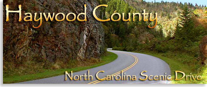
| Home | Sign up for Highlander Newsletter | Order Free Brochures and & More Info | Purchase Unique Gifts, Books, Photos & Artwork |
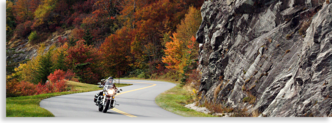
| Blue Ridge Parkway through Haywood County |
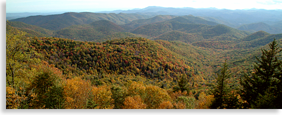
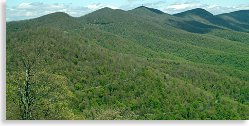
Forest Heritage National Scenic Byway from Haywood County |
Two of Western North Carolina's most outstanding scenic driving tours, are located within the southern region of Haywood County. One is a National Scenic Byway, the other a National Scenic Parkway. They crisscross each on a journey that will take you to the very pinnacle of the High Country where you can literally touch the sky, or to the great mountain depths where you can ride a natural water slide below the slopes of the mighty Blue Ridge Mountains. Join us while we guide you along the Forest Heritage Scenic Byway and a section of the renowned Blue Ridge Parkway.
Forest Heritage National Scenic Byway from Haywood County
This scenic driving tour begins on the northern slopes of the Balsam Mountains in southern Haywood County. The scenic byway title 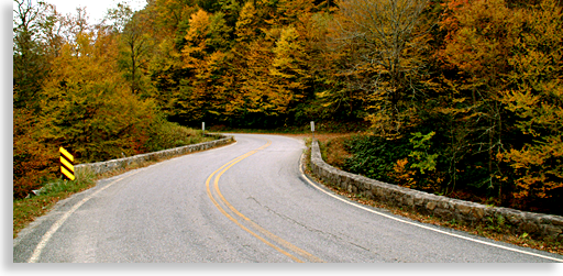 “Forest Heritage” definitely lives up to its namesake. The 79-mile loop tour will take you deep into the heart of the Pisgah National Forest with mountain peaks reaching more that 6,000 feet above sea level. Beginning in Waynesville take US 276 to the town of Woodrow, it’s the next town east of Waynesville. At the intersection of US 276 and State 215, head south on State 215.
Following the West Fork of the Pigeon River you begin your ascent along the southern slopes of the Balsam Mountains thru the Shining Rock Wilderness Area. State Highway 215 is a two lane pave road that will take you to the top of the mountain where the highway crosses the Blue Ridge Parkway. Before your climb you’ll pass a beautiful mountain lake, Lake Logan.
Lake Logan is on private property and is not open to the public, though you can park near the bridge where the Pigeon River feeds 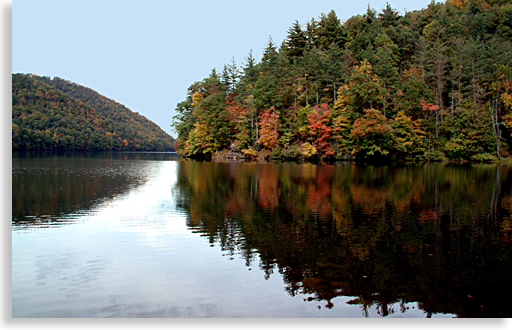 the lake. From the public highway you can freely photograph the lake with its crystal blue waters reflecting the tree-lined shores.
Two-mountain wilderness areas lie along this ascent up State 215. The first and largest of the two is Shining Rock Wilderness on the east side of the road or left when climbing the grade. Many long hiking trails lie in this area for serious hikers such as Art Loeb Trail, Fork Mountain Trail, Little East Fork Trail, Sam Knob Trail, Mountain to Sea Trail and the Cold Mountain Trail which lies deepest in the heart of Shining Rock Wilderness. The 6,030-foot Cold Mountain sets at the very center of the wilderness and whose summit is only reachable by hiking trails carrying the name of the famed novel.
The other or second wilderness is the Middle Prong Wilderness which lies to the west of the scenic drive with long strenuous trails accessing its interior. Long high mountain hikes will take you along the Green Mountain Trail, Haywood Gap Trail and the Buckeye Gap Trail.
Continuing your scenic driving tour on the Forest Heritage National Scenic Byway you will pass several large and small waterfalls that are viewable from the roadside. There is an outstanding waterfall along the right side of the road passing under the highway and immediately descending down a long drop on the opposite side of the road to your left. There’s shoulder parking along the roadside, you’re going to want to take photo advantage of this waterfall, witnessing the beauty of this unobstructed natural wonder. Keep your camera close at hand, waterfalls are abundant along this scenic tour.
Reaching the Blue Ridge Parkway at the top of the grade State 215 crosses the Parkway and descending down the opposite slope of the Balsam Mountains. As mentioned earlier, the Forest Heritage National Scenic Byway is a 79-mile loop; this loop crosses the Blue Ridge Parkway twice, once at State 215 and at US 276, which is further east from State 215. The interesting fact that this scenic loop tour crosses the Parkway twice, allows travelers the opportunity to turn this loop tour into a figure eight tour. A look at a map outlining the Forest Heritage National Scenic Byway will show the loop route with the Blue Ridge Parkway dissecting the center of the loop. The figure eight alternative allows road tour enthusiast a chance to enjoy a breathtaking section of the Parkway by heading east, along the Parkway to junction US 276 and turn south on Wagon Gap Road (US 276.) The Wagon Gap Road overlook has an outstanding view of Wagon Gap Road as it ascends up from the valley to the south and over the gap, which you can only see from this overlook along the Blue Ridge Parkway.
This alternative route is a personal choice and adds miles to the present 79-mile loop if you choose to add the Parkway; this Highlander tour will follow the traditional charted route along the Forest Heritage National Scenic Byway.
Back at the intersection of State 215 and the Blue Ridge Parkway, cross the Parkway and begin your long descent along State 215 south. You have just left Haywood County and entered Transylvania County North Carolina. Scenic views and an abundance of hiking trails and waterfalls lie along this downward journey along the headwaters of the French Broad River.
Waterfalls are abundant in the district and just as many trails leading to them yet most of these falls are well off the scenic byway though three waterfalls are close to the tour route. These three waterfalls, listed from upper mountain to lower mountain are Courthouse Falls, Bird Rock Falls and Diamond Creek Falls at the end of US 215. Highway US 215 reaches its ends where the scenic drive reaches the intersection of US 64 at the town of Rosman in Transylvania County; take a left onto US 64 as you continue your loop driving tour.
From Rosman, Highway 64 follows the French Broad River to the mountain town of Brevard. Follow Highway 64 just past Brevard where you will come to highway US 276. Turn left onto US 276 and head back into the forest for an exciting climb up the southern face of the Balsam Mountains. This ascent along the Forest Heritage National Scenic Byway is filled with sights and information about these beautiful woodlands you won’t want to miss and is probably the most renowned section of this entire scenic driving tour.
The Cradle of Forestry is here, the Pisgah Center for Wildlife Education is a must see, Sliding Rock and its natural cascading water slide is a favorite, plus there’s Sycamore Falls, Looking Glass Falls and other special features including a historical settlement are located along this route.
This isolated region was once a part of George Washington Vanderbilt’s famed Biltmore Estate once 125,000 acres. It was George W. Vanderbilt’s personal inspiration that this great forest be restore and preserved for the public's enjoyment and posterity. George Vanderbilt originally hired Gifford Pinchot to manage his vast Biltmore forest. From this experience Mr. Pinchot became interested in formulating the national forest policy and moved on. George Vanderbilt then hired Dr. Carl Schenck who began the Biltmore Forest School around the turn of the 20th century, which set forth a foundation for national forestry rejuvenation and preservation. Both Pinchot and Schenck went on to serve as chiefs of the U.S. Forest Service.
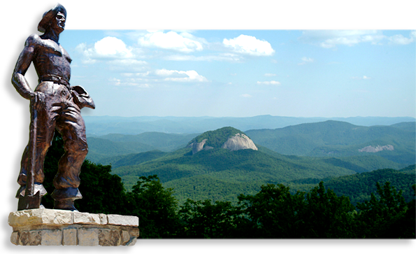
In 1968 Congress set aside 6,500-acres of the Pisgah National Forest for the Cradle of Forestry in America on property purchased from the Biltmore Estate creating a school in honor of Dr. Carl Schenck who began the first school of forestry at Biltmore Estate. This isolated region is considered the birthplace of the National Forest Service with the Cradle of Forestry School resting below the shadow of Looking Glass Mountain’s glistening rock face which can be fully viewed without obstruction from a Blue Ridge Parkway overlook just west of Wagon Road Gap.
 The Pisgah Center for Wildlife Education which is operated by the North Carolina Wildlife Resources Commission. The center focus on the wildlife and habitats of the North Carolina's Mountain region. The exhibits are designed to show the relationship between people and wildlife, and the natural
 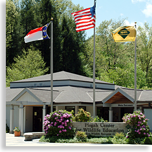 resources they share. In addition to the exhibits, you will find hiking trails a trout raceway and gift shop and is an enjoyable visit for all ages.
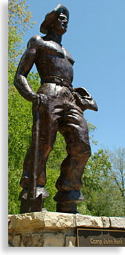
One feature located just outside the center and essential to what the mountains are today is a commemorative bronze monument featuring one lone figure who represents the millions of Civilian Conservation Corps' (CCC), men that brought life back to these forests. The commemorative Camp John Rock plaque reads "This monument is dedicated to the young men who served in the Civilian Conservation Corps, 1933 - 1942. During the Great Depression, three million unemployed young men found meaningful work in the President Franklin Roosevelt's CCC. Known as the "Tree Army," the CCC worked out of camps on Federal and State lands to improve America's forest, parks, and agricultural lands. Our country is indebted to the CCC for their conservation of our lands and their contribution to public recreation. Here stood Camp John Rock (F-1, F-28), the finest established on U.S. Forest Service lands in North Carolina, where Companies 402 and 428 served between 1933 and 1941."
The drive up the mountain will take you back to the Blue Ridge Parkway where you’ll cross the Wagon Road Gap and begin your descent down US 276 re-entering the Shining Rock Wilderness in Haywood County. A great downward view of Wagon Road Gap can be seen from the Blue Ridge Parkway at the upper overlook just west of Wagon Road Gap.
The name Shining Rock derives its name from the visible white quartzite at the mountain peak’s 5,640-foot summit. This route is laden with its own sites and wonders, as you will wind down the mountain following the Little East Fork of the Pigeon River along the eastern edge of Cold Mountain. Long trails in this region of the Shining Rock Wilderness are Old Butt Knob Trail, Shining Creek Trail, Big East Fork Trail plus you can access the Cold Mountain Trial from here also.
Highway 276 ascends along the Pigeon River as this scenic tour winds back to the little town of Woodrow just east of Waynesville ending this scenic driving tour along the Forest Heritage National Scenic Byway.
The Forest Heritage National Scenic Byway is a full day journey with many sights and experiences to take advantage of, the drive alone will take about 3 full hours so plan at least a half a day for a shorter trip.
To shorten your driving tour trip schedule in half so you can enjoy more of the features of Haywood County’s Shining Rock Wilderness Area, follow the same starting route take a left turn when you reach the intersection of highway 215 and the Blue Ridge Parkway, follow the Parkway to US 276 and turn left again. This alternative driving tour will cut your trip in half and give you a chance to stretch your legs and enjoy the wilderness lands of the Balsam Mountains northern slopes and the Cold Mountain region.
Blue Ridge Parkway - Haywood County
The pinnacle of all scenic drives and we’re not just talking locally. Beginning on the edge of the Shenandoah National Park in the Blue Ridge Mountains of Virginia the Blue Ridge Parkway travels 469-miles southwestern along the high ridges and over the tall mountain peaks of the Blue Ridge Mountains ending at the southern gateway to the Great Smoky Mountains National Park.
The southern and western edge of Haywood County is bordered by this high range Parkway traveling between 50 to 70 miles along the upper heights of the county. These sections of the Parkway crest the border between Western North Carolina’s Pisgah and Nantahala National Forest. Here, high above Haywood County the Parkway includes many of the '  best attraction the Parkway 469-miles has to offer.
The highest point along the Parkway lies just above the southern end of the Haywood County, you can not only drive this extraordinary scenic drive you can also stop and hike the high country to take in unusual sites and natural wonders true to the great Blue Ridge and Smoky Mountains Province. Several overlooks view down into Haywood County, offering an opportunity to see much of the county in one long view, stretching its ever so broad mountain shoulders across the distant horizon.
You can access the Parkway from Maggie Valley along US 19, or take highway 23/74 south from Waynesville. To get the most out of your scenic road trip the Highlander suggest starting out early and begin your journey from the town of Cherokee where the Blue Ridge Parkway officially ends at the southern entrance gateway into the Great Smoky Mountain National Park.
You can reach the southern most entrance to the Parkway by taking US 441 north to where the junction of the National Park and Parkway meet. The Blue Ridge Parkway will be on the right or east side of the road if your vehicle has a compass.
This one-day trip along the parkway skirts the ridge tops 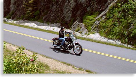 offering numerous overlooks with spectacular mountain views. The Blue Ridge Highlander suggests you follow the parkway from its entrance at Cherokee and follow along the western and southern edge of Haywood County to the city of Asheville in neighboring Buncombe County, which is on the eastern fringes of Haywood County. Many natural features will capture your attention along the way including 11 of the 25 roadway tunnels located along North Carolina’s section of the Blue Ridge Parkway.
You’ll reach the Blue Ridge Parkway’s highest point just above Haywood County at Richland Balsam Overlook 6,053 feet above sea level. Along your journey you’ll witness magnificent mountain views, the clearer the weather the further the view.
You’ll pass many roadside sites that have well-marked, well-traveled hiking trails such as Devil’s Courthouse which takes hikers up to a large bare rock mountain overlook. Grave Yard Fields area offers visitors a beautiful waterfall view located in a high mountain top valley. The waterfall can be hiked to or can be seen from the parking lot overlook at Grave Yard Fields. A trail leads from the overlook to the edge of the cascading falls in the valley, a short distance below. A hike up to Mount Pisgah has been a favorite activity since this section of the Blue Ridge Parkway official opening.
Further along the Parkway you’ll witness views of Looking Glass Mountain to the south of the Parkway. The view from several southern overlooks of the “glass mountain” are exceptional, especially after a rain when the gigantic bald mountain face glistens in the sunlight, living up to its name, Looking Glass Mountain.
Some of the other views from the Blue Ridge Parkways overlooks are of Cold Mountain, the Cradle of Forestry, Mount Pisgah and the historical wagon trail crossing at Wagon Road Gap.
The end of this scenic drive along the Blue Ridge Parkway ends in the next county east of Haywood County, Buncombe County.
Descending into Buncombe County the Parkway crosses the French Broad River before reaching the southern end of the mountain city of Asheville, a great place to stop a grab a meal before heading back. Asheville is an exceptional mountain city with grand turn of the 20th century architecture.
When heading back to Haywood County you can either go back the way you came and enjoy a whole different view of the Blue Ridge Parkway, being that you’ll be going west this time instead of east, or you can take the shorter route back to Haywood County via Interstate 40 west, the average traveling time back to Waynesville along I-40 is 45-minutes compared to the 2 1/2 to 3 hour long drive back across the Blue Ridge Parkway. Personally the Highlander prefers the parkway trip back when time can afford itself.
If the weather forecast is predicting a full day of rain, the Parkway will be consumed in cloud cover. In the winter if there is a prediction for snow or ice storm the Parkway will be closed.
When you visit Haywood County, you must visit the Blue Ridge Parkway it’s an extraordinary opportunity to witness an engineering man-made wonder. The road provides a smoothed unblemished surface due to the fact that no commercial vehicles are allowed on its roadway. High mountain roads can be a little intimidating to inexperience high country drivers, but your confidence will grow with each passing mile. Make sure to fill your gas tank you won’t find any gas stations along the parkway though the planners of the Blue Ridge Parkway conveniently planned pit stops in the valley along the parkway 400-plus miles. Also be sure to take plenty of liquids and a hearty lunch if you plan on any hiking trips along the way.
An additional scenic road tour in southern Haywood County also accesses the Blue Ridge Parkway; this scenic tour is the Forest Heritage National Scenic Byway that the Highlander will cover in the next section.
Learn more about Waynesville, Maggie Valley and Haywood County
Waynesville, Maggie Valley and Haywood County Points of Interest
Sign up for the Blue Ridge Highlander Newsletter, Messages from the Mountains
to find out first about our new feature stories, road trips and special offers
Your e-mail addresses will not be sold or given away to anyone.
Privacy Policy
Interested in your business being on the Highlander, click here...
Let our visitors tell you about the Highlander...
Click the feathers to go to the Highlander site
map...

Your e-mail addresses will not be sold or given away to anyone.
Let our visitors tell you about the Highlander...
Click the feathers to go to the Highlander site
map...
Highlander Special Interests
Great Mountain Attractions and Destinations Links to All Highlander Advertisers
Blue Ridge Highlander Mountain Emporium Art Gallery Photo Gallery Handmade Products Book Store
Magazine, Virtual Tours and Scenic Road Trips Creative Mountain Classes Just for Kids
Living Green and Eco Friendly in the Mountains Gardening in the Mountains Mountain Recipes
Mountain and Native American History Nathanael O. Smith - Storyteller Mysteries, Myths and Legends in the Mountains
Mountain Cathedral Charities and Fundraisers
Great Mountain Retreats
Adventure • Art • Cooking • Corporate • Family • Friend • Yoga • Wellness • Youth
Learn More About the Towns and Cities in the Mountains
North Georgia Mountains Western North Carolina Mountains
Up Country South Carolina Tennessee River Valley and Mountains
Great Smoky Mountains Blue Ridge Parkway
Move to or Invest in the Mountains
Real Estate • Log Homes • Cabins • Homes • Land • Acreage • Commercial Real Estate
North Georgia Mountain Real Estate Western North Carolina Real Estate
Tennessee River Valley and Smoky Mountain Real Estate
Interior Design and Furniture Shops Schools in the Mountains
Traveling • Living • Enjoying the Mountains
Log Cabin Rentals • Vacation Rentals • Resorts • Condos • Inns • Hotels • Bed and Breakfasts
Luxury Resorts and Spas in the Blue Ridge and Smoky Mountains
North Georgia Mountain Lodging Western North Carolina Lodging Tennessee River Valley Lodging
Plan a Mountain Wedding or Gatherings Conference, Meeting and Retreat Facilities
Vineyards • Wineries • Tasting Rooms Agri-Tourism Farmer's Markets
Yoga Retreats • Spas in the Mountains
Events and Festivals in the Mountains Theatre • Concerts • Mountain Entertainment
Restaurants, Dining and Catering in the Mountains
Shopping in the Mountains Blue Ridge Highlander Mountain Emporium and Art Gallery
Artists, Art Galleries and Art Associations in the Mountains Museums, History and Culture in the Mountains
Family Fun in the Mountains Just for Kids
Adventure and Outdoor Fun in the Mountains
Mountain Adventure Horseback Riding, Stables and Trails Mountain Bike Trails
White Water Rafting and Adventure Zipline • Canopy Tours Fishing in the Mountains
Boating and Marinas Camping and RV Parks ORV Adventures
Scenic Mountain Drives Mountain Golf Courses Mountain Day Use and Picnic Areas
National Parks in the Mountains National Forest Service in the Mountains State Parks in the Mountains
Waterfalls in the Mountains Lakes in the Mountains Rivers, Creeks and Trout Streams in the Mountains
Nature and Wildlife in the Mountains Mountain Birding Hiking Trails in the Mountains
More Information
Home Site Map Advertise on the Highlander Link to the Highlander Contact the Publisher
designed, produced and hosted by

of C. Wayne Dukes and Sherry Bell Dukes. 1996 - 2014, except where otherwise stated. All rights reserved, reproduction,
downloading, and/or duplication of any sort is strictly prohibited, all violations will be prosecuted. Legal Policy.
If you have any questions, or comments, regarding this site, e-mail the Highlander.