
story continued....
The majority of the high country of the
Blue Ridge Mountains is in Western North Carolina. North Carolina has
the tallest and largest number of mountain ranges in the Blue Ridge Province.
The eastern North Carolina mountains are under the protection and care
of the Pisgah
National Forest. The western North Carolina Mountains are under
the protection and care of the Nantahala
National Forest, with the massive range of the Great
Smoky Mountains as a separate National Park.
Jackson County is in the far eastern Nantahala National Forest. The southern
half of Jackson County North Carolina, like Oconee County South Carolina
and Rabun County Georgia are on the east-side of the Eastern Continental
Divide. This natural watershed guides the waters of the Blue Ridge Mountains
east to the Atlantic Ocean, while watershed on the western side of the
Eastern Continental Divide guides the mountain waters to the Gulf of Mexico.
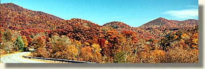
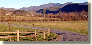
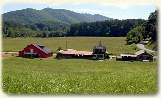
Jackson County is a world unto itself in the high country, it has green mountain valleys at 3,500 feet and higher, and mountain peaks raising to 5,000 above sea level. Jackson County is a land of dense forest, mountain lakes, whitewater streams and countless waterfalls. The county slogan here is, "take time, unwind and set your own pace."
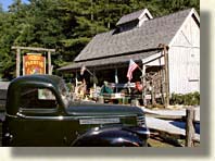
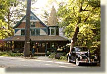
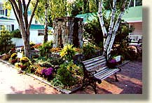
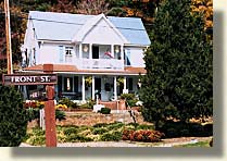
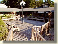
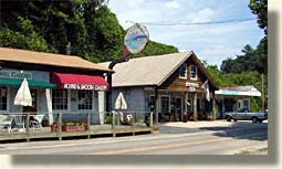
Cashiers is a most notable mountain town. Its charm is unparalleled. Cashiers has all the appeal of a artisan community. Their downtown shopping area at the crossroads of State Highway 107 and US 64 is a unique setting. Sprawling out in four directions, is a community of stylish rustic design. Every building has a character all its own. Specialty shops, antique shops, authentic mountain art galleries, along with a variety of dining and regional lodgings. Cashiers is unique due to what appears to be, its lack of early settlement progress. The towns' present commerce seems to have been born in the latter part of the 20th Century, with an ambiance of pride and small town hospitality. There are many prime residential developments in this region of the county.
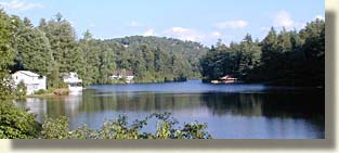
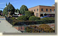
If you feel a need for an extra side trip, you can pickup State Highway 107 north of Cashiers and travel the high mountain back country of Jackson County. You'll come in contact with the high lake shores of Lake Glenville before you descend into the upper valleys of Jackson County. You will soon arrive in the sizable mountain town of Sylva. With the Great Smoky Mountains to the north and the Blue Ridge Parkway cresting the mountain peaks to the east, Sylva rest in the heart of the Southern Blue Ridge Mountains.
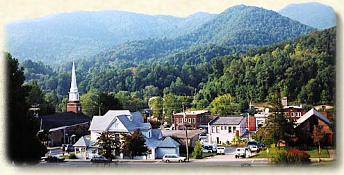
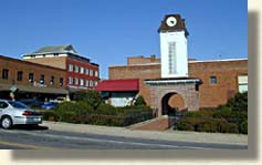
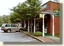
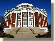
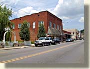
As a railroad town and county seat, Sylva prospered into a thriving mountain community. There are several blocks of mostly brick buildings in its downtown shopping and dining district, that give Sylva the distinction of a, "designated Main Street town." The ominous white courthouse, perched high on a hill is visible for miles against multiple mountain backdrops. A "short piece" up the road to the west is the perfect accent to the bustling town of Sylva, its the quaint village town of Dillsboro.
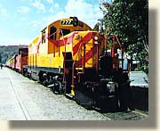
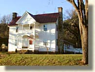
Dillsboro's charm dates back to its historical landmarks of the 1880's. The WNC Railroad passing through Dillsboro made this a prosperous community, until several floods caused many businesses to relocate to Sylva. The town has maintained its character with its center pieces being a popular hotel built in 1884 and the central offices of the Great Smoky Mountain Railway. Laced throughout this charming village are many shops and eateries creating a well rounded experience for a small town walkabout.
Leaving Cashiers on US 64 west, we begin to journey along the northwest crest of the picturesque Sapphire Valley. A sizable valley of pristine beauty surrounded by high mountain peaks of bare granite. Our present trip takes us west along the Southern Highroads Trail on our way to the town of Highlands in Macon County. You can't help but notice the stately entryways to numerous private communities along this route of tight turns and dips. This is a obviously a land of milk and honey. Money pays for mountain dreams here, roughing it is what the other guy does. Regardless of what you might think about material wealth, this particular high mountain country is impressive.
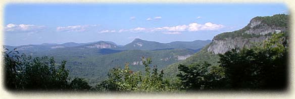
The Highland's area of Macon County is a 4,000 foot plateau with dominating mountain peaks of bare granite and heath bald summits. Two mountain tops in the area offer stupendous views, Whiteside Mountain and Satulah Mountain. Both mountain summits are accessible by short easy trails. You can reach Whiteside Mountain off US 64, between the town of Cashiers in Jackson County and the town of Highlands in Macon County. Satulah Mountain can be reached by going south on State Highway 28 at the intersection of US 64 and State Highway 28. Satulah Mountain is unique because it is classified as a heath bald. The dwarfed white oak and dwarfed white pine on the summit can be as old as 200 years and no bigger then 10 inches in diameter.
The section of the Southern Highroads Trail, between Cashiers and Highlands will test and hone your driving skills for the adventures ahead. All you really need to know is...sharp left, followed by a sharp right and repeat, and repeat, and repeat. My greatest fear was that I'd hit a straight patch of road and automatically turn sharp left or right out of habit.
Coming into the town of Highlands, you'll find the town to be top drawer, a beautiful town, door to door from one end of the street to the other. A multitude of antique and specialty shops, galleries, dining and lodgings.


In picturing the town of Highlands you'll have to imagine numerous daily visitors strolling up and down the streets in their designer wear. The business day ends and the town is still full of visitors, vehicles parked on both sides of the street with a double isle of vehicles parked in the center boulevard. Now imagine 90% of these vehicles as luxury sedans, foreign sports cars and top of the line Sport Utility Vehicles. The town of Highlands and surrounding communities have set precedence in luxurious mountain living. Ample parking is available, park and stroll the town, do a little shopping and take in good meal.....bon-appetite.
The Southern Highroads Trail leaves behind the Highlands and the eastern slopes of the Eastern Continental Divide and travels west on US 64. It's time to get excited, we're headed down a high river gorge of waterfalls, whitewater rapids and a wonder in asphalt cruising.
 After
passing a small lake with a spill over dam, we come in contact with the
Cullasaja River as it cuts a deep path down the formidable Cullasaja River
Gorge. US 64 follows the northeastern banks of the Cullasaja River, along
the river's pre-historic rock formations. The engineering feats that laid
the path for this road's construction is extraordinary. The necessity
of connecting the plateau of the upper Highlands with the low valley town
of Franklin, North Carolina had only one conceivable route, the gorge.
The road wasn't built for beauty sake, that is a secondary benefit. The
natural wonders themselves were the real obstacle. At times, US 64
After
passing a small lake with a spill over dam, we come in contact with the
Cullasaja River as it cuts a deep path down the formidable Cullasaja River
Gorge. US 64 follows the northeastern banks of the Cullasaja River, along
the river's pre-historic rock formations. The engineering feats that laid
the path for this road's construction is extraordinary. The necessity
of connecting the plateau of the upper Highlands with the low valley town
of Franklin, North Carolina had only one conceivable route, the gorge.
The road wasn't built for beauty sake, that is a secondary benefit. The
natural wonders themselves were the real obstacle. At times, US 64 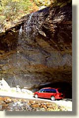 literary
portages around huge waterfalls while skirting the rivers edge. The road
clings to the sheer granite walls of Cullasaja River Gorge, as an enormous
waterfall plunges below the road. All the while being surrounded by the
beautiful hardwood Nantahala
National Forest.
literary
portages around huge waterfalls while skirting the rivers edge. The road
clings to the sheer granite walls of Cullasaja River Gorge, as an enormous
waterfall plunges below the road. All the while being surrounded by the
beautiful hardwood Nantahala
National Forest.
As we continue along the Southern Highroads Trail, US 64 brings us to a natural wonder, Bridal Veil Falls. This waterfall is approximately 1 1/2 miles west of Highlands. On the northern side of the road, you'll see a thin veil of water about 15 feet wide, falling 120 feet into a depression in the earth. A pull off from US 64 takes a vehicle directly behind the falls giving the illusion of a vehicle being under the falls, a real photo opportunity.
While taking a few shots of the falls, an elderly gentleman approached me and commented that he drove through here about 40 years ago and remembered the falls originally divided the up and down journey of US 64. Today, the falls sit safely to the side of the main route.
Continue touring down the Cullasaja River
Gorge for less than a mile, and you will come 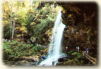 to
Dry Falls. There is limited parking on the river side of the gorge. A
short hike down a well paved trail, takes you to a stunning view of a
wide waterfall pouring 75 feet down the Cullasaja River Gorge. A large
cliff overhang is located directly behind the waterfall, with the trail
passing behind-under the waterfall. The trail continues up a short distance
for what I consider the best position for photographing Dry Falls. From
behind the falls you can look through the waterfall and down the gorge
into steep, rugged river country. The experience and accessibility of
a waterfall of this magnitude is surely a blessing to bestow.
to
Dry Falls. There is limited parking on the river side of the gorge. A
short hike down a well paved trail, takes you to a stunning view of a
wide waterfall pouring 75 feet down the Cullasaja River Gorge. A large
cliff overhang is located directly behind the waterfall, with the trail
passing behind-under the waterfall. The trail continues up a short distance
for what I consider the best position for photographing Dry Falls. From
behind the falls you can look through the waterfall and down the gorge
into steep, rugged river country. The experience and accessibility of
a waterfall of this magnitude is surely a blessing to bestow.
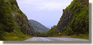
The Southern Highroads Trail winds sharply down US 64 as we begin to catch a glimpse of whitewater along the Cullasaja River. The river begins to drop quickly away, as the road hugs the upper granite wall of the Cullasaja River Gorge. At a certain point, the road appears to suddenly disappear, the Cullasaja River drops
down a steep vertical wall into the most picturesque point of the gorge. The trail creeps and turns around exposed granite bends with a sheer drop off into the gorge on the southwestern side of the road. Lower Cullasaja Falls can be heard from a distance, it drops an impressive 250 feet down the gorge and into the river bed below. Visibility of the falls is non existent from this side of the road, only a few narrow pull offs along the outer edge of the road allows for a view of the falls. The driving experience and visibility is heightened when traveling the other direction, up the gorge, due to the road's outer edge drop off, offering a spectacular view of Cullasaja Falls.
Leaving the gorge, US 64 pours into the basin of lower Macon County, or more notably, the valley of the Cowee Gem Region. This area is a popular retreat for rock hunters throughout the world. Macon County is known as one of the world's three main locations for hunting gem stones, along with Burma and Thailand. This region of North Carolina produces Corundum and gem-quality rubies and sapphires from many mines scattered throughout the valley and mountain slopes.
Located in the very center of the valley is the town of Franklin in Macon County. Known as the, "gem capital of the world," Franklin is a sizable town by mountain standards. It is located at the crossroads of US 64 and US 23/441. US 23/441 is also the corridor route north to the Great Smoky Mountains.
The wealth of Macon County is not only in its mineral and logging yield, it also has a wealth of history. The earliest notable migration into the Southern Highlands by white settlers were the Scots. The Scottish Clans first migrated into the northeastern United States, and then began migrating into the southern Blue Ridge Mountains. It was the Scots that influenced the name, "Southern Highlands." The Scottish Tartan Museum is located in Franklin and can provide you with insight into the lives of the original "Highlanders."
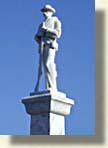
Mining began here in the 1800's with progress following. Franklin was a rail town of substantial commerce. The downtown district is lined with old architecture and an impressive white marble Civil War Monument. Shopping, dining and a variety of lodging can be found in Franklin and surrounding Macon County. Several large chain stores and eateries are also located in the Franklin area.
Traveling west on US 64, we make our approach toward the eastern wall of the Nantahala Mountains. All we have to do is climb the steep grade of the outer wall and pass through a gap cut into the high ridge. Just before we reach the gap, there's a large overlook on the south side of the road. There's an enormous view of lower Macon County to the east, completely surrounded by high mountain knobs and balds averaging over 5,000 feet above sea level. The mountains to the far east are the high peaks and balds of the Blue Ridge Parkway, to the north is the back bone of the Great Smoky Mountains. Our journey takes us west into the high remote tops of the Nantahala Mountains.
 Continuing
west we pass through a deep man-made gap, due to the fact that the actual
mountain gap is too steep to maneuver. This extended gap was blasted and
hand drilled out of solid granite and is equal in height on both sides
of the road, forming stone bookends along this asphalt storybook. Occasionally
you'll see rock climbing or repelling along side the road.
Continuing
west we pass through a deep man-made gap, due to the fact that the actual
mountain gap is too steep to maneuver. This extended gap was blasted and
hand drilled out of solid granite and is equal in height on both sides
of the road, forming stone bookends along this asphalt storybook. Occasionally
you'll see rock climbing or repelling along side the road.
As we clear the gap's western exit, you'll
once again cross the Appalachian
Trail, as it works its way up from the Tallulah Basin region of
Rabun County in North Georgia. The Appalachian Trail continues north from
here, over the high peaks of the Nantahala Mountains crossing the Nantahala
River Gorge and on into the high country of the Great Smoky Mountains. 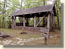
Just past the Appalachian Trail, there is a special unposted landmark, a modest open air chapel and cemetery. To find this special place, take the first paved road to the left, at the Standing Indian turnoff. Drive about a mile down this road, the chapel is on the right. This is not a place to picnic or for children to play. This is a peaceful place to reflect on an intimate view of mountain life, a quiet place in a hard mountain land.
As US 64 crosses the broad back of the Nantahala Mountains for several miles, you'll find a unique region of the Nantahala National Forest, due to its isolation and high altitude. This, is the place to get lost in with a companion and some good hiking boots. This route across the Nantahala Mountains is known a Chunky Gal Gap.
 Cruising
the highway, we get a sense of mountain grandeur as we literally drive
amongst mountain tops to our left, and right, both forwards and backwards.
Coming to the unmarked community of Rainbow Springs, we cross the upper
reaches of the Nantahala
River, this river follows a course northward across the Nantahala
Mountains eventually leading to the large remote Nantahala Lake.
Beyond the lake the river flows north into a long deep gorge with steep
granite walls. This gorge was known to the local Native Americans as the
gorge of the "Noonday Sun." The name derived from the fact that
sunlight only shines directly into the gorge, when the sun is at its highest
position, namely 12:00 noon.
Cruising
the highway, we get a sense of mountain grandeur as we literally drive
amongst mountain tops to our left, and right, both forwards and backwards.
Coming to the unmarked community of Rainbow Springs, we cross the upper
reaches of the Nantahala
River, this river follows a course northward across the Nantahala
Mountains eventually leading to the large remote Nantahala Lake.
Beyond the lake the river flows north into a long deep gorge with steep
granite walls. This gorge was known to the local Native Americans as the
gorge of the "Noonday Sun." The name derived from the fact that
sunlight only shines directly into the gorge, when the sun is at its highest
position, namely 12:00 noon.
We soon cross the Macon County line and enter Clay County, North Carolina. Still in the upper reaches of the western Nantahala Mountains, we find ourselves in the Buck Creek area of Chunky Gal Mountain. The Buck Creek area is classified and protected as a "special interest area," a renowned site for ultra basic rocks and the study of botany, minerals and gems. Coming through the western gap on Chunky Gal Mountain, we find ourselves being sling shot down the slopes, toward the valley below.
The western and southern views of the mountains before us are breathtaking. There are two overlooks going down this mountain that deserve a stop and look see. The two mountains to the south, Hightower and Eagle Mountain display great perspective in size, making all else appear small and insignificant.
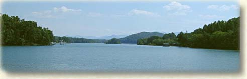
Continuing on US 64 we slide into the valley and make our way west, until we reach the northern shores of Lake Chatuge. Earlier on the Southern Highroads Trail, we skirted the shores of the southern banks of Lake Chatuge, when we passed through Hiawassee in Towns County, North Georgia. The south side of Lake Chatuge in North Georgia is about 10 miles away from the northern end of Lake Chatuge which is in North Carolina. Its southern shores are in the Chattahoochee National Forest and its northern shores in the Nantahala National Forest.
What makes this end of the lake different, is its laid back attitude. Clay County is more of an artisan community of both artist, new arrivals and local mountain folks. All are seeking and finding a more a creative environment. Hayesville is the main commerce center for Clay County. It is a quiet town of quaint charm and quality. The classic design of this town is worthy of a movie setting. Perched on the center square is the old red brick courthouse surrounded by a park on three sides. The four main streets are mostly lined with long porch covered sidewalks, containing various types of shops and dining. The Licklog Players, a serious and dedicated acting group make the Peacock Theater in Hayesville their home.
Tusquittee Valley to the north of Hayesville is a beautiful valley surrounded by high mountains. You'll find a lot of open pasture lands and meadows, laden with scattered homes and estates, a great place to find that creative inner-self. The lands of Clay County to the west are made up of rolling hills within the river valley, and small mountain backdrops to the pastures and farmlands.
Continuing west on US 64, we come to the vicinity where Clay County meets Cherokee County, North Carolina. Just a couple of miles south of US 64, claimed by and beloved by both counties is the historical John C. Campbell Folk School in Brasstown, North Carolina. The school is of great interest to anyone appreciative of the mountain arts. The campus is spread out over many acres of mountain farm land, It is laid out in a rustic setting of both historical and newly built structures. To know more about this unique experience check out the Blue Ridge Highlander's story "Keeping the Art Alive."
Continuing on US 64, we enter the eastern side of Cherokee County. Some of the nicest farm and pasture land lie here, surrounded by distant mountains. This is mountain river bottom land, the river being the Hiwassee River. The Hiwassee River flows from Lake Chatuge and heads west. We follow the north river bank around several miles of tight curves and soon arrive at the town of Murphy.
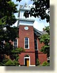
Murphy is a good size mountain town, with a strong downtown center. The most notable feature in Murphy is the old statuesque blue marble courthouse. The blue marble used in construction of this landmark was quarried just a few miles to the northeast in the town of Marble. Other historical buildings in Murphy house a variety of shops, galleries, dining and lodging. Murphy is an old railroad hub with many historical markers, such as the gathering stockade that held the Cherokee people before their trek on the "Trail of Tears." An even older landmark declares the nearly 500 year old visit of DeSoto and his expedition in the 1540's.


Off the Southern Highroads Trail, northeast of the town of Murphy and just past Marble, on US 19/129, is an elongated valley with a remarkably flat valley floor of prime farmland. Bordering this fertile valley are two long mountain ranges. The northern mountain barrier is made up of the Snowbird Mountains, an eastern extension of the Unicoi Mountains. The southeastern mountain range is the Valley River Mountains, a western extension of the Nantahala Mountains. These two mountain ranges converge at the upper north end of the valley forming what is called the Nantahala River Gorge. Just before you reach the adjoining mountain ranges you come to the town of Andrews, North Carolina.
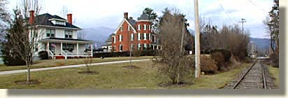
Built as the result of the iron rail expansion, Andrews grew and prospered with the completion of the Richmond and Danville Railroad in the spring of 1890. The Main street is made up of several blocks of mostly brick buildings with a number of large stature, turn of the century homes. Most notable are the vintage mansions along the tracks just parallel to Main street.
Cherokee County is a land where the rivers
converge. Flowing southwest through Andrews, the Valley River leads us 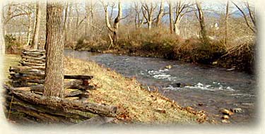 back
down the valley to Murphy where the Valley River into Hiawassee Lake.
The Hiwassee River cuts directly through Murphy and flows northwest into
Hiwassee Lake. Flowing north from Union County, Georgia the Nottely River,
also flows into the broad channels of Hiwassee Lake, in northern Cherokee
County. Hiwassee Lake's northern shores are located below the southwest
region of the remote Unicoi
Mountains. The waters of the Hiwassee River continue on to Appalachia
Lake and exit the Appalachia Dam at the very edge of the states of North
Carolina and Tennessee. Here the river bends and joins an extraordinary
engineering feat, created by a turn of the century railroad in order to
follow the picturesque Hiwassee River through the mountains and into the Tennessee
River Valley.
back
down the valley to Murphy where the Valley River into Hiawassee Lake.
The Hiwassee River cuts directly through Murphy and flows northwest into
Hiwassee Lake. Flowing north from Union County, Georgia the Nottely River,
also flows into the broad channels of Hiwassee Lake, in northern Cherokee
County. Hiwassee Lake's northern shores are located below the southwest
region of the remote Unicoi
Mountains. The waters of the Hiwassee River continue on to Appalachia
Lake and exit the Appalachia Dam at the very edge of the states of North
Carolina and Tennessee. Here the river bends and joins an extraordinary
engineering feat, created by a turn of the century railroad in order to
follow the picturesque Hiwassee River through the mountains and into the Tennessee
River Valley.
Our journey doesn't follow the lake shores or river, the regions of northern Hiwassee Lake are quite remote and off the Southern Highroads Trail, our journey continues west on US 64.
 Welcome
back to the four lane. Keeping the Unicoi
Mountains to our north, we travel deeper into Cherokee County,
across the country side until we come to the intersection of US 64 and
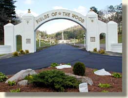
State 294. Here you'll notice a sign going north stating, "Fields
of the Wood." Field
of the Woods is a spiritual retreat, emphasizing the teaching of
the Bible. Like the Bible, Fields of the Wood is bigger than life. You'll
find the Ten Commandments laid out on the side of the mountain, a display
of the flags of the world in the shape of a cross on the mountain top,
several reproduction of structures from the Holy land. A biblical teaching
path leads you up the steps of a mountain trail to an overlook and a small
grass covered landing strip. The Fields of the Wood is open to the public
year round, free of charge, although, donations are welcomed and its just
a few miles off the Southern Highroads Trail. This is not an amusement
park, it is a serious retreat, please show respect when you visit.
Welcome
back to the four lane. Keeping the Unicoi
Mountains to our north, we travel deeper into Cherokee County,
across the country side until we come to the intersection of US 64 and
State 294. Here you'll notice a sign going north stating, "Fields
of the Wood." Field
of the Woods is a spiritual retreat, emphasizing the teaching of
the Bible. Like the Bible, Fields of the Wood is bigger than life. You'll
find the Ten Commandments laid out on the side of the mountain, a display
of the flags of the world in the shape of a cross on the mountain top,
several reproduction of structures from the Holy land. A biblical teaching
path leads you up the steps of a mountain trail to an overlook and a small
grass covered landing strip. The Fields of the Wood is open to the public
year round, free of charge, although, donations are welcomed and its just
a few miles off the Southern Highroads Trail. This is not an amusement
park, it is a serious retreat, please show respect when you visit.
Back on the Southern Highroads Trail going west on US 64, we soon come to the eastern slopes of Pack Mountain on the north side of the road. This mountain marks the western edge of Cherokee County, North Carolina.
![]()
Sign
up for the Blue Ridge Highlander Newsletter, Messages from the Mountains
to find out first about our new feature stories, road trips and special offers
Your e-mail addresses will not be sold or given away to anyone.
Privacy
Policy
Interested in your business being on the Highlander, click here...
Let our visitors tell you about the Highlander...
Click the feathers to go to the Highlander site
map...

Your e-mail addresses will not be sold or given away to anyone.
Let our visitors tell you about the Highlander...
Click the feathers to go to the Highlander site
map...
Highlander Special Interests
Great Mountain Attractions and Destinations Links to All Highlander Advertisers
Blue Ridge Highlander Mountain Emporium Art Gallery Photo Gallery Handmade Products Book Store
Magazine, Virtual Tours and Scenic Road Trips Creative Mountain Classes Just for Kids
Living Green and Eco Friendly in the Mountains Gardening in the Mountains Mountain Recipes
Mountain and Native American History Nathanael O. Smith - Storyteller Mysteries, Myths and Legends in the Mountains
Mountain Cathedral Charities and Fundraisers
Great Mountain Retreats
Adventure • Art • Cooking • Corporate • Family • Friend • Yoga • Wellness • Youth
Learn More About the Towns and Cities in the Mountains
North Georgia Mountains Western North Carolina Mountains
Up Country South Carolina Tennessee River Valley and Mountains
Great Smoky Mountains Blue Ridge Parkway
Move to or Invest in the Mountains
Real Estate • Log Homes • Cabins • Homes • Land • Acreage • Commercial Real Estate
North Georgia Mountain Real Estate Western North Carolina Real Estate
Tennessee River Valley and Smoky Mountain Real Estate
Interior Design and Furniture Shops Schools in the Mountains
Traveling • Living • Enjoying the Mountains
Log Cabin Rentals • Vacation Rentals • Resorts • Condos • Inns • Hotels • Bed and Breakfasts
Luxury Resorts and Spas in the Blue Ridge and Smoky Mountains
North Georgia Mountain Lodging Western North Carolina Lodging Tennessee River Valley Lodging
Plan a Mountain Wedding or Gatherings Conference, Meeting and Retreat Facilities
Vineyards • Wineries • Tasting Rooms Agri-Tourism Farmer's Markets
Yoga Retreats • Spas in the Mountains
Events and Festivals in the Mountains Theatre • Concerts • Mountain Entertainment
Restaurants, Dining and Catering in the Mountains
Shopping in the Mountains Blue Ridge Highlander Mountain Emporium and Art Gallery
Artists, Art Galleries and Art Associations in the Mountains Museums, History and Culture in the Mountains
Family Fun in the Mountains Just for Kids
Adventure and Outdoor Fun in the Mountains
Mountain Adventure Horseback Riding, Stables and Trails Mountain Bike Trails
White Water Rafting and Adventure Zipline • Canopy Tours Fishing in the Mountains
Boating and Marinas Camping and RV Parks ORV Adventures
Scenic Mountain Drives Mountain Golf Courses Mountain Day Use and Picnic Areas
National Parks in the Mountains National Forest Service in the Mountains State Parks in the Mountains
Waterfalls in the Mountains Lakes in the Mountains Rivers, Creeks and Trout Streams in the Mountains
Nature and Wildlife in the Mountains Mountain Birding Hiking Trails in the Mountains
More Information
Home Site Map Advertise on the Highlander Link to the Highlander Contact the Publisher
designed, produced and hosted by