 Menu
Menu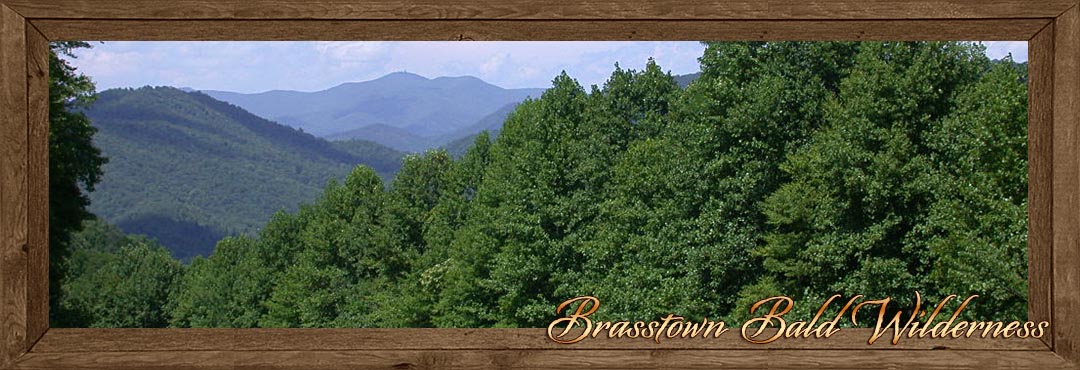
Brasstown Bald - Wilderness Area and Trails
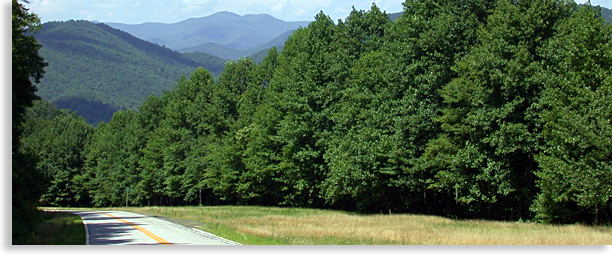
Brasstown Bald and Wilderness Area, located in the heart of North Georgia’s mountainous Chattahoochee National Forest has the highest unobstructed overlook in North Georgia, and is considered a virtual stairway to the heavens for visitors to the high country. Its mountain summit at 4,784-feet lies within the 12,975-acre Brasstown Bald Wilderness Area with breathtaking vistas reaching into the four states of the southern Blue Ridge Mountains. The good news is that the roadway to the mountaintop is paved.
 Located next to the Visitors’ Center near the summit of Brasstown Bald is a large paved parking area. The Visitors Center access to the summit is by way of a steep half-mile paved hiking trailhead that follows through a thick forest containing mountain laurels, rhododendrons, seasonal wildflowers and dwarfed trees. Also conveniently located near the summit’s trailhead is a shuttle bus that will take visitors to the top viewing area and return trip for a modest fee. Shuttle service is available daily from Memorial Day to the end of October.
Brasstown Bald is considered the crown jewel of North Georgia’s mountaintops. Balds exist mainly on the tallest mountaintops of the Blue Ridge - Smoky Mountains and are mostly void of any tall trees. These balds are normally covered in low shrubs, dwarf trees or tall grasses and are considered a mystery in their making. Both geologist and Cherokee folklore have their own separate ideas regarding the characteristics of balds and how they were formed.
On a clear day from Brasstown Balds circular 360-degree stone observation deck, located at the mountain summit, visitors can gaze upon Georgia’s mountainous high country and the neighboring mountains along the Eastern Tennessee border to the west. Looking eastward are the distance-mountains of Up Country South Carolina. Lining the horizon to the north, stand the towering mountains of Western North Carolina and the northern shoreline of Lake Chatuge in the valley below. Standing watch over the observation deck is an old circular wooden fire-lookout-tower that adds a personal sense of character to the balds’ summit and can be barely made out when viewed from the valley below; this structure is closed to the public.
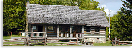
Also located along the observation deck is a must see museum with excellent exhibits displaying the lives of early settlers, and a narrow gage locomotive used to maneuver steep mountain slope along a narrow gauge rail line. There are also exhibits of Native American culture, legends and myths along with displays of local wildlife. The museum also houses a small theater featuring a film of the natural geological history of this local mountainous region.
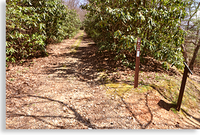
Other features located near the Visitor Center at the parking area below the summit, are three hiking trails, along with the trail that leads to the summit. A nearby boulder field surrounds most of the bald and is accessible from the trail. The mountaintop parking area has a flourishing amount of mountain laurels and rhododendrons that are native to the Blue Ridge Mountains. A list and access to these trails are listed below.
On occasions, the Visitor Center host special events that are quite an experience to enjoy since these festivities take place on an actual mountaintop. Information for these past and future events can be obtained at the local Chattahoochee National Forest District Office.
Inexperienced hikers as well as experienced hikers should never hike alone. It’s highly recommended to bring along a companion, drinking water and some energy bars or other manageable snacks for a day hike. As a courtesy always pack out what you bring in and leave the least amount of footprint (human impression) as possible allowing others to enjoy the same unique experience as you have enjoyed.
Brasstown Bald and Wilderness Area in Towns County Georgia is an outdoor experience that says it all; it is magnificent, indescribable and awe-inspiring.
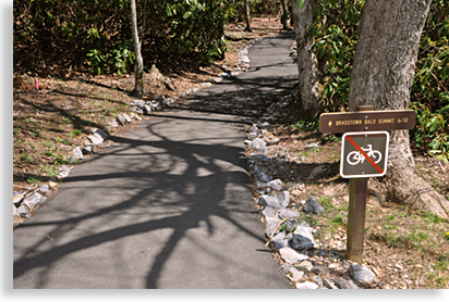
Brasstown Bald Summit Trail
 There are two ways one can reach the upper summit of Brasstown Bald. From the parking area you can either take a comfortable shuttle trip to the top when the shuttle is operating from Memorial Day thru the end of October, or you can hike the better than half-mile trail to the top. The shuttle trip does require a modest fee.
The Brasstown Bald Summit Trail is located next to the Visitor Center (housed in a cabin), and is paved to the top. Though inviting at first glance the trail becomes quite steep once the getting gets going. The good news is the downhill trip is easier on the lungs and leg muscles although harder on the knees. I recommend a good walking stick to lean on along the way up and extra bracing for the way back down.
Wagon Train Trail
Accessible from the summit parking area at Brasstown Bald, this 5.6-mile trail follows along a wide pathway that was originally intended to be a part of GA Highway 66 (or 68, the research information might be a little cloudy.) The trailhead is a little tricky to find at first, to reach the trailhead hikers will need to follow the Brasstown Bald Summit Trail for about 100-yards. The Wagon Train Trail is located on the right marked by a plaque.
 The stress rating for this trail is moderate to strenuous depending on if your going up or down the mountain. The trail either finishes or begins in the valley below just 2 miles south of the town of Young Harris GA.
Even though the trail offers a grade suitable for a roadway I would recommend hiking the trail from top to bottom for a more enjoyable experience providing you have an extra vehicle waiting for you at the trails end. The trail offers great views especially in early spring or late autumn when views are less obstructed by leaves. The trail also follows past cliff formations and through upper boulder fields featuring rock tripe, lichens, club moss, reindeer moss and old man’s beard.
Season wildflowers such as mountain buttercups, white and purple violets, four varieties of trillium and other wildflower plants, line the forest trail.
Originally, local residents from the valley below used the Wagon Train Trail for annual excursions. The trail is wide due to the fact it was planned as a roadway. After the plan was canceled the trial became a means of holding onto the past for the local descendants of the original hardy mountain pioneers. Their quest to the mountaintop offered a sense of community spirit that stills echoes along the trail.
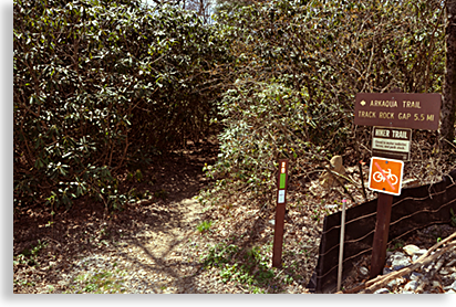
Arkaqua Trail
This 5.5-mile trail descends westward along a ridge top to the valley below and is either accessible from the back end of the summit parking area atop Brasstown Bald, or across the road from the Track Rock Archaeological Area along Track Rock Road just off US 76 in the valley below.
 Hikers along the trail will pass through a northern hardwood forest while viewing scenic outbreaks through the trees, plus wildflowers and various herbs on their way to the Blue Bluff Overlook.
Along the way hikers will pass Chimney Top Mountain and be able to view Rocky Knob to the south. The stress rating for the trail is moderate to strenuous and not recommend for casual hikers. For most hikers that choose to take on the trail, I personally recommend the descent from the Brasstown Bald mountaintop parking area to the Track Rock Valley below providing you have someone drop you off at the top of the trail, and pick you up at the bottom of the trail or have a parked vehicle awaiting you at the end of your hike.
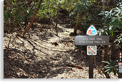
Jack’s Knob Trail
This 4.5-mile trail is accessible from the Brasstown Bald parking area at the top of the mountain or at the entrance to the Brasstown Bald Wilderness Area next to GA Highway 180.
 The trip up to the top from the lower entrance is only half the distance since the trail crosses GA Highway 180 before continuing on to where it connects to the Appalachian Trail to the south. The upper trailhead is located directly across the parking area from the Visitor Center as you enter the parking area. The ideal hike would be to bring two vehicles leaving one at the entrance parking area and the other at the mountaintop parking area and begin your journey from the top down. It’s an incredible journey and enjoyable accomplishment if one chooses to hike Jack’s Knob Trail both ways.
Jack’s Knob Trail was originally constructed in the 1930’s by the Civilian Conservation Corps, and then reconstructed by the Chattahoochee Forest Service in the 1980’s. The trail is rated moderate to strenuous as it follows southward along a ridge-line dividing the boundary between Towns and Union County. The trail continues along the ridge just west of and parallel to the ascending paved roadway to the summit of Brasstown Bald. The trail crosses GA Highway 180 at Jack’s Gap then continues on to the Chattahoochee Gap where it accesses the Appalachian Trail.
Use the Links below to discover your special interests...
Overview of Towns County & the Countryside
The Communities within Towns County
Brasstown Valley
Hiawassee Georgia
Young Harris Georgia
Waterways in Towns County
Hiwassee River
Lake Chatuge
Waterfalls in Towns County
Fun, Recreation & Adventure
Appalachian Trail
Brasstown Bald Wilderness & Trails
Chattahoochee National Forest
Georgia Mountain Fairgrounds
Jackrabbit Mountain Recreation Area
Trackrock Archaeological Area
Hamilton Gardens
Scenic Road Trips
Towns County Scenic Drives
Georgia Mountain Fairgrounds in Hiawassee Georgia
1311 Music Hall Road • Hiawassee, Georgia 30546 • 706.896.4191 • GeorgiaMountainFairgrounds.com
Campgrounds at Georgia Mountain Fairgrounds
706-896-4191 • 96 Pavilion Road • Hiawassee GA 30546 • Campgrounds at Georgia Mountain Fairgrounds
Hamilton Gardens at Georgia Mountain Fairgrounds
Open Every Day 8:00 am - Dusk
96 Pavilion Road • Hiawassee, GA 30546 • 706-896-4191 • Hamilton Gardens
Tim Noland, Realtor® - Buyer's Agent • North Georgia & Western North Carolina
When looking to buy mountain property, you need someone that not only understands the mountains, you need someone that specifically represents you, the buyer. When you choose to work with a Buyer's Agent you are assured that you have an agent that is truly looking for your best interests, someone that will not only find what you are looking for, but someone that will negotiate the best price possible.
10886 Old Hwy 64 West • Brasstown, NC 28902 • 828.557.1009 • GreatMtnRealEstate.com
Rafting on the Ocoee River
Professional river outfitter with over 30 years experience. Our safety record is unsurpassed in the industry. We believe our staff is simply the best in the business. Guides are chosen for their character and enthusiasm for sharing the outdoors with you.
Call today to start your adventure...828-835-3275 • GreatMtnAdventures.com
Rafting on the Nantahala River
Experience this unforgettable whitewater adventure through the gorge. The Nantahala is exciting, and a great time, but not as wild as the Ocoee. This is a river that you can bring children on as young as seven years old.
Experience the excitement of Patton's Run, the fun and splash of Tumble Dry, the rush and roar of riding Class III Nantahala Falls. For a bigger thrill, try taking one of our Duckies down the river!
Call today to start your adventure...828-835-3275 • GreatMtnAdventures.com
Zip Line Canopy Tours...Nantahala Gorge • Chattooga Ridge • Asheville • Pigeon River
Whichever course you choose you are sure to enjoy the newest outdoor adventure to hit the US.
All our courses offer a soaring and gliding experience naturally fueled by a gradual drop in elevation. All trips offer fully guided tours with 2 or more Rangers on at least 10 zips, 4 bridges beginning with a training course at each location.
Call today to start your adventure...828-835-3275 • GreatMtnAdventures.com
Trout Treks • Bass Fishing • Wade • Pan Fishing • Fly Fishing • Private Trophy Trout Waters • Drift Boat Trips
So much water to choose from and an adventure you'll never forget.
Call today to start your adventure...828-835-3275 • GreatMountainFishing.com


The Blue Ridge Highlander logo, all photography, design, graphics, artwork, writing, digital images, etc are the Copyright © of C. Wayne Dukes and Sherry Bell Dukes, 1996 to current day, except where otherwise stated. All rights reserved, reproduction, downloading, and/or duplication of any sort is strictly prohibited, all violations will be prosecuted. Legal Policy. If you have any questions, or comments, regarding this site, e-mail the Highlander.