
| Home | Sign up for Highlander Newsletter | Order Free Brochures and & More Info | Purchase Unique Gifts, Books, Photos & Artwork |
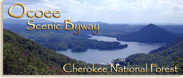
Ocoee Scenic ByWay
The Ocoee Scenic Byway on Highway 64 in eastern Tennessee’s Polk County was the first designated National Forest Scenic Byway in the United States. The Ocoee Scenic Byway also includes the Chilhowee Mountain Drive on Forest Route FR77 just across from Ocoee Lake in the Cherokee National Forest. This 26 mile two lane road trip connects what’s referred to locally as Upper and Lower Polk County.
The roadway the Ocoee Scenic Byway follows was originally called the Old Copper Road. Copper mining in the mid 1800’s in Upper Polk County opened this doorway into the high country; this 26-mile scenic drive is richer in history than in copper. Today very few locals refer to it as the Old Copper Road, even less call it the Ocoee Scenic Byway. What every one does call it is the Ocoee River Gorge, home of one of the nations finest whitewater rivers and scene of the 1996 Canoe/Kayak Slalom Olympic Competition. The 1996 Summer Olympics were held in Atlanta two hours away making this natural whitewater river easy to access.
The Ocoee Scenic Byway is made up of two parts. The first part of the scenic route is along Highway 64. This 19-mile course follows most of the Old Copper Road thru the Ocoee River Gorge then continues along the shores of Ocoee Lake. The second part of the trip is just off Highway 64 on FR77, a 7-miles drive up Chilhowee Mountain will take you to views that can’t be missed.
When gold was discovered in the North Georgia Mountains in the 1830’s prospectors searching for profits didn’t find gold in Upper Polk County they were looking for, what they found was and abundance of copper ore, the largest find in North America. The quickest way to the market for the copper was down the Ocoee River thru the steep and narrow Ocoee Gorge. The Whitewater River was to wild for transportation so a road had to be cut from the sheer walls of the rock-faced gorge to accommodate heavy wagon loads of copper ore. During this time several bridges crisscrossed the wild Ocoee River often being washed out due torrential flooding, parts of the Old Copper Road still exist just as it did in the 1800’s, rugged, rocky and narrow with most of it under the paved scenic highway.
For nearly a hundred years the road itself didn’t improve much. The railhead was in Cleveland Tennessee 33 miles away in the Tennessee River Valley. Alternative routes would have taken a week to reach a railway. The Old Copper Road took an average of two days, one day thru the Ocoee Gorge, another day thru the foothills and then nearly halfway across the Tennessee Valley. Eventually the railroad found its way into the Copper Basin in the late 19th early 20th century using a route thru North Georgia’s Blue Ridge Mountains. This new rail line exited the mountains of the Cherokee National Forest north of the Ocoee River following the route of the Hiwasseee River. A new railhead depot was established in the town of Etowah in the Tennessee Valley. No railway has ever conquered the Ocoee River Gorge.
The history of copper mining in southeastern Tennessee’s Copper Basin region and the Polk County communities of Copperhill, Ducktown and Isabella are quite interesting stories. The Burra Burra Museum in Ducktown, tells the story of these historic times. The Blue Ridge Highlander also contains some history of copper mining and the effects it had on the region, just search our site under copper mining, Polk County or the Ocoee River.
Our journey on the Ocoee Scenic Byway & Chilhowee Mountain Drive begins in the former mining town of Ducktown and is one of the Highlander’s more favored scenic tours (copper is no longer mined in the region.) You can begin this journey in either the upper or lower end of the gorge, the Highlander prefers the journey down the gorge from the high mountain valley, there’s a sense of excitement riding along the bank of a scenic river route just as the rafters and kayakers do on the river, its just more thrilling that way. Either way you take the trip the beauty speaks for itself. The Highlander has made many journeys into the gorge; its natural beauty is visually captivating with each change in season. Along the journey you’ll witness man attempt to harness the wild nature of a whitewater river. The Highlander has written several feature stories on the Ocoee River Gorge, compiling valuable and entertaining information. Links to other features and information are listed at the end of the driving tour or refer to our Blue Ridge Highlander search engine.
To start your journey take Highway 64/74 west from Ducktown crossing the northwest corner of the Copper Basin. Climbing the first ridge you enter the Cherokee National Forest, reaching the crest of the first ridge top you’ll see a forestry sign guiding you to turn left at Boyd Gap, this paved road leads 1/8 of a mile to the parking area and overlook. The view is great with the Cohutta Mountains rolling northward on an angle along the valley floor. Far below the overlook is the Ocoee River winding westward through the mountains and foothills of Cherokee National Forest. When leaving Boyd Gap make a left back at Highway 64/74.
For several miles you’ll roll comfortably along a four-lane highway to the bottom of the grade. Reaching the mouth of the gorge you’ll see on the left the Ocoee Whitewater Center, home of the 1996 Canoe/Kayak Slalom Olympic Event. The center is a great place to stop and enjoy, a welcomed experience for all travelers. The walls of the gorge rise up in one single swoop from the floor of the Ocoee gorge, completely enclosing the river narrowing the sky along the roof of the gorge.
There’s much to do at and around the Whitewater Center, The Highlander has composed short list of what’s available at the center. The Whitewater Olympic course is the only competition course ever designed along a natural riverbed in the world. This section of the Ocoee River was dormant for decades due to the rivers diversion for hydroelectric power at the turn of the 20th Century. The dormant river was awakened in 1996 once the course was designed for competition. Today low water current always runs thru the Olympic course’s riverbed yet it’s only on weekends during the rafting season and during other current kayaking and slalom competitions that the rivers natural current is fully released. Other times for instance the river current is opened is are after heavy rains or unscheduled dam release. When the waters are low visitors use this section of the river as a swimming hole, see the Highlander’s story on the “Ole’Blue Hole.”
The Ocoee Whitewater Center blends beautifully along the riverbed with its large river stone columns. Adjoin to one side of the center is a made waterfall with a water fed pond at the top of the falls and a catching pool at the bottom. Sidewalks leave the center spanning out along both sides of the riverbank providing access to picnic areas these walkways are great for eye level spectator views of rafters and kayakers riding the rivers whitewater curls rated at Class 5 Rapids.
Exiting the Ocoee Whitewater Center on foot you’ll find the Liberty Bridge spanning across the river, the bridge was built during the Olympics. If you were to follow the trail pass the entrance of the bridge and continuing along the riverbank and find yourself hiking a section of history along the Old Copper Road. Here you can examine for yourself up close just how the road was cut out of raw stone thru the wilderness gorge along the riverbank dating back to 1849. The trail is rugged today, level and easy to hike yet many large rocks protrude from the ground making it a rough ride for wagon loads of smelted copper.
Back at Liberty Bridge you can cross over to the other side of the Ocoee River, the bridge connects visitors to the hiking trail along the opposite river bank where you will find more picnic areas offering move great and views of the Olympic course. Also on the opposite side of the river is the trailhead for the Tanasi Trail System with 30 miles of various hiking and mountain biking trails. These rather recently constructed trails are the site of the Southeast Regional Championship race series. The Tanasi Trail System is a series of looped trails with two extended trails carrying names like “West Fork Trail,” and “Thunder Rock Express Trail.”
The Ocoee Whitewater Rodeo Event here at the Ocoee Whitewater Center relives its whitewater course competition days each year, bringing back the excitement and roar of the crowd echoing thru the Ocoee Gorge. Colorful flags of the Olympic nations members are flown along the rivers banks during these special events. The Ocoee Olympic Whitewater Center is a place you’ll want to make time for on this scenic drive.
Leaving the center continue west on highway 64/74 along the Ocoee Scenic Byway. The Ocoee River is divided into three sections, the Upper Ocoee the Middle Ocoee and the Lower Ocoee. The Upper Ocoee begins a couple of miles above the Ocoee Whitewater Center and ends pass the center where you reach the Old Wooden Dam at the narrow bend of the river. The parking lot just above the dam is reserved for rafting companies only; public parking is next door along the same bank of the river.
This section of the Ocoee River is where the river truly gets its naturally wild river namesake. The gorge narrows significantly here as the river begins to drop quicker with each mile, the rock walls and cliffs begin to climb higher along the gorge thru natural canyon like formation with one way in and one way out.
The Old Wooden Dam, or rather Ocoee Dam 2 was built in 1912; the dam is now covered in concrete leaving the natural shape of the old wooden dam very obvious. On the opposite bank the river is a water flow lock that feeds into an enclosed wooden flume that runs along the upper south wall of the gorge maintaining its height while the river drops for five miles. Here at the dam you can walk along the upper river bank on a wooden deck located on the road side of the river and observe rafters at the “putt in.” Just below the dam at the put in water spills over the dam creates an impressive wide waterfall. This wall of water churning against the river boulders below creates a surge of whitewater and a Class 4 rapid called “Grumpy’s.”
Continuing down the Ocoee Scenic Byway you’ll follow the rivers edge parallel to the whitewater rafters, you get a driving sense of riding the river itself with its moderate descent along the river’s winding bends. The Middle Ocoee is the Highlander’s favorite part of the Ocoee River along the Ocoee Scenic Byway. The canyon like walls of the gorge and the sharp jutting out of boulders and cliffs along the drive add to the wild flavor of the gorge. Small parking areas along the riverbanks offer front row seating where you can watch rafters and kayakers challenge the whitewater rapids armed only with oars and screams of excitement. Driving thru the gorge you can’t help but notice the many small waterfalls that shower over the cliffs and down the sheer rock face of the gorge, they are even more amazing after a good rainfall. At one location on the right side of the road is a series of cascading waterfalls with a parking area and hiking trail, this location is called Goforth Creek.
As the Ocoee River and Ocoee Scenic Byway continue to drop down the gorge you can follow the wooden water box flume as it clings to the upper wall of the gorge, crossing trestles where the river gorge gives way to smaller gorges at a natural split in the Ocoee Gorge. The Middle Ocoee ends at the old redbrick powerhouse and submerge dam, the last two rapids here are called Hell’s Hole and Powerhouse Ledge both are Class 4 rapids. Also ending just beyond the dam are the whitewater rafting trips journey. At the “take out” (rafting companies only,) the rafters stop here and load the large rubber fun boats onto trailers and bus roofs the good news though is our scenic drive is only half over.
The Lower Ocoee has a gentle flow, the Ocoee Scenic Byway follows its path thru the lower gorge, casual canoeing is enjoyed along this part of the river, half along the Lower Ocoee River is a public access put in an take out with conveniently located restrooms.
Reaching the end of the Lower Ocoee the scenic byway exits the narrow gorge, here you will find yourself on the edge of Lake Ocoee also know as Parksville Lake. This emergence at the mouth of the Ocoee River Gorge was once the location of an Inn used mostly by the copper mining teamsters, marking this spot the halfway point of their journey from Copperhill to Cleveland Tennessee and the railhead. The Inn no longer exist just a historical marker shows the approximate spot. With mountains bordering on the east and north sides of the Lake Ocoee and steep foothills bordering the southern and western edge of the lake, the Ocoee Scenic Byway finds itself skirting along the northern edge of Lake Ocoee.
The Parksville Dam on Ocoee Lake was completed in 1912 by the Tennessee Power Company. The dam marks the spot where the Ocoee River exist the mountains and flows into the Tennessee River Valley. Ocoee Dam 2, the actual wooden dam in the gorge was constructed in 1912. In 1939 The TVA (Tennessee Valley Authority,) took over the Ocoee River Systems and the Ocoee Dam 3 began construction in 1941 and made operational in 1943. Ocoee Dam 3 is located above the gorge on the edge of the Copper Basin.
The trip along the lake offers numerous parking areas where you can access the lakeshore to view the beautiful blue waters of Ocoee Lake. Halfway from the Ocoee Gorge and the Parksville Dam is a ranger station. The Ocoee Ranger District of the Cherokee National Forest is located on the right hand side of the road. Just before the ranger station is the next turn, FR77 and the second part of the Ocoee Scenic Byway. This forestry road travels up Chilhowee Mountain and is paved and steep for the first couple of miles then levels off once your reach the mountain ridge top. The mountain has a long ridge across the top stretching several miles; along this ridge are several great overlooks. The views facing west are of the broad Tennessee Valley and the Cumberland Plateau spanning across the horizon. Below Chilhowee Mountain is the Ocoee Lake and Parksville Dam south of the lake is a maze of steep foothill that run for miles and bordered to the south and west by tall mountains, west of the foothill is the Great Valley of North Georgia. The southwestern edge of the Blue Ridge Mountain can be seen running along the east and southern portion the horizon with the Cohutta Mountain Wilderness dominating the eastern landscape.
Chilhowee Recreation Area on Chilhowee Mountain offers picnicking, camping, fishing, a modest mountain lake, Lake McCamy with swimming and boating. There are 9 nine hiking and biking trails located in the Chilhowee Recreation Area, only the Scenic Spur Trail prohibits biking. A fan shaped waterfall can be reach by the Benton Falls Trail and in the Rock Creek Gorge Scenic Area you’ll find an isolated gorge with 11 waterfalls. Historical Civil War times found a group of Confederate soldiers camped along the ridge when a surprise attacked by Union soldiers left several dead; a plaque along the road marks the campsite.
At the end of FR77 the pavement ends and the campground and additional recreation area begins. You can follow the unpaved forestry road into the recreation area for a look see or return back down the mountain the same way you came reaching Highway 64 at the bottom of the mountain and turn right. This last part of the journey the scenic drive continues along Ocoee Lake taking you pass the marina at Parksville before you soon arrive at the end of Ocoee Lake where there’s a dam overlook on the left side of the road. The Parksville Dam is quite impressive considering it was constructed in 1911, bringing power to the region nearly 30 years before the TVA would change the Tennessee Valley and the western Blue Ridge Mountains forever. Below the dam is a public park along side the north side of the river; here you’ll find a working model replica of the Ocoee River at the Ocoee Whitewater Center. The model was used as a layout for the 1996 Summer Olympics whitewater competition course. The model when running is fed by a diverted stream from the Ocoee River.
The entrance to the park is on the left just pass the entrance to the offices for the dam; if you drive pass the intersection of Highway 64 and county road 314 you just missed the entrance for the park.
This intersection marks the end of the journey or if you’re coming from the opposite direction the beginning of the Ocoee Scenic Byway & Chilhowee Drive. If you have another 10-miles in you the Blue Ridge Highlander recommends you take county road 314 north to Benton in Lower Polk County. This road leads along the valley floor below Chilhowee Mountain; it takes you through pasturelands and small valley farms over shadowed by the big mountain ridge to the east. Here you can see the unobstructed view of a section of the western wall of the Blue Ridge Mountains.
Polk County and McMinn Monroe Counties to the north are collectively known as the Tennessee Overhill country. The name derives from the Cherokee Overhill People, who occupied the area before their removal in the 1830’s. The Tennessee Overhill is a story rich in history, a land of beauty, resource and recreation. Check out other stories and features within the Blue Ridge Highlander concerning this region of Tennessee’s Blue Ridge Mountains.
the Highlander
Although very enjoyable, the mountains can be a driving challenge to a flatlander (no offense), to help you with your new venture, take a look at our driving tips.
Sign up for the Blue Ridge Highlander Newsletter, Messages from the Mountains
to find out first about our new feature stories, road trips and special offers
Your e-mail addresses will not be sold or given away to anyone.
Privacy Policy
Interested in your business being on the Highlander, click here...
Let our visitors tell you about the Highlander...
Click the feathers to go to the Highlander site
map...

Your e-mail addresses will not be sold or given away to anyone.
Let our visitors tell you about the Highlander...
Click the feathers to go to the Highlander site
map...
Highlander Special Interests
Great Mountain Attractions and Destinations Links to All Highlander Advertisers
Blue Ridge Highlander Mountain Emporium Art Gallery Photo Gallery Handmade Products Book Store
Magazine, Virtual Tours and Scenic Road Trips Creative Mountain Classes Just for Kids
Living Green and Eco Friendly in the Mountains Gardening in the Mountains Mountain Recipes
Mountain and Native American History Nathanael O. Smith - Storyteller Mysteries, Myths and Legends in the Mountains
Mountain Cathedral Charities and Fundraisers
Great Mountain Retreats
Adventure • Art • Cooking • Corporate • Family • Friend • Yoga • Wellness • Youth
Learn More About the Towns and Cities in the Mountains
North Georgia Mountains Western North Carolina Mountains
Up Country South Carolina Tennessee River Valley and Mountains
Great Smoky Mountains Blue Ridge Parkway
Move to or Invest in the Mountains
Real Estate • Log Homes • Cabins • Homes • Land • Acreage • Commercial Real Estate
North Georgia Mountain Real Estate Western North Carolina Real Estate
Tennessee River Valley and Smoky Mountain Real Estate
Interior Design and Furniture Shops Schools in the Mountains
Traveling • Living • Enjoying the Mountains
Log Cabin Rentals • Vacation Rentals • Resorts • Condos • Inns • Hotels • Bed and Breakfasts
Luxury Resorts and Spas in the Blue Ridge and Smoky Mountains
North Georgia Mountain Lodging Western North Carolina Lodging Tennessee River Valley Lodging
Plan a Mountain Wedding or Gatherings Conference, Meeting and Retreat Facilities
Vineyards • Wineries • Tasting Rooms Agri-Tourism Farmer's Markets
Yoga Retreats • Spas in the Mountains
Events and Festivals in the Mountains Theatre • Concerts • Mountain Entertainment
Restaurants, Dining and Catering in the Mountains
Shopping in the Mountains Blue Ridge Highlander Mountain Emporium and Art Gallery
Artists, Art Galleries and Art Associations in the Mountains Museums, History and Culture in the Mountains
Family Fun in the Mountains Just for Kids
Adventure and Outdoor Fun in the Mountains
Mountain Adventure Horseback Riding, Stables and Trails Mountain Bike Trails
White Water Rafting and Adventure Zipline • Canopy Tours Fishing in the Mountains
Boating and Marinas Camping and RV Parks ORV Adventures
Scenic Mountain Drives Mountain Golf Courses Mountain Day Use and Picnic Areas
National Parks in the Mountains National Forest Service in the Mountains State Parks in the Mountains
Waterfalls in the Mountains Lakes in the Mountains Rivers, Creeks and Trout Streams in the Mountains
Nature and Wildlife in the Mountains Mountain Birding Hiking Trails in the Mountains
More Information
Home Site Map Advertise on the Highlander Link to the Highlander Contact the Publisher
designed, produced and hosted by

of C. Wayne Dukes and Sherry Bell Dukes. 1996 - 2014, except where otherwise stated. All rights reserved, reproduction,
downloading, and/or duplication of any sort is strictly prohibited, all violations will be prosecuted. Legal Policy.
If you have any questions, or comments, regarding this site, e-mail the Highlander.