
story continued....
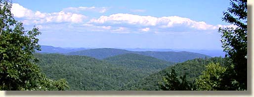
The "Upcountry" has been a land revered by South Carolinians since colonial time. This region of the Great Blue Ridge Mountains is virtually in the upper northwestern back wall of the state of South Carolina.
First settled in the 1720's this remote region of South Carolina developed rather independently from the low-country of Charleston and central South Carolina. Five counties make up the "Upcountry" region of South Carolina with Oconee County being to the farthest northwest corner.
During the American Revolution, a great number of lowland and coastal South Carolinians were loyal to the British. Early settlers of the "Upcountry," were not. These American Patriots resisted the invasion of the British backed Colonial troops from the south, led by British commander Major Patrick Ferguson. Remove this group of poorly armed and trained American Patriots, and the British could have completed the defeat of the southern colonies and marched north to destroy the Continental Army led by Georgia Washington. Little did the British know, these formidable mountain folks were no push over. Using guerrilla tactics learned in back country battles with Native Americans, the mountain folks of the "Upcountry" not only resisted the English Loyalist, they also defeated and destroyed the army that was sent against them, turning the fate of the war. This forced Cromwell to advance directly north to engage Washington, leaving the southern colonies undefeated. The word "Upcountry" has become synonymous to the idea of freedom and independence in South Carolina.
This part of the journey on the Southern Highroads Trail allows for a more relaxed time behind the wheel to take in the countryside views of the "Upcountry" as we descend from the upper reaches of the Blue Ridge Mountains, but not for long. Traveling southeast on US 76, we'll enter the town of Westminster in Oconee County.
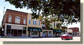
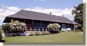
Westminster is a quaint railroad town surrounded by farms and meadow lands. In order to find the old historical main street district of Westminster you'll need to drive to the middle of town, turn north off of US 76 and drive one block. The old depot stands along the tracks with the well preserved charm of Westminster's old shopping district just across the street. What you'll find along this historical avenue in Westminster, is an assortment of shopping, local dining and turn of the century architecture.
Leaving Westminster, we also leave behind US 76 and pickup scenic route, State Highway 183 going north. Following this route approximately 10 miles, we reach Walhalla, also in Oconee County.
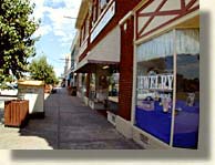
Walhalla's oldest building dates back to 1792. It was originally built as one, in a series of blockhouses that acted as garrisons for troops protecting the South Carolina frontier until 1799. It became the Oconee Station after the railroad came, making Walhalla a railroad hub and final stop, due to the Blue Ridge Mountain wall barrier. Walhalla is a town rich in heritage and architecture, a historical church and stately homes, as well as an old downtown district with shops, galleries, dining and lodging, offering enjoyment for the casual strollers or the overnight visitors.


Both towns of Walhalla and Westminster are located only a few miles west of a chain of large lakes on the far eastern edge of Oconee County. Starting at the northern end, they are Lake Jocassee, Lake Keowee and Hartwell Lake. These lakes offer a wealth of water recreation to the "Upcountry" region of South Carolina.
Continuing on the Southern Highroads Trail, we travel north from Walhalla on State Highway 28, until we reach the junction of State Highways 28 and 107. To remain on the official Southern Highroads Trail you must exit onto State Highway 107 north.
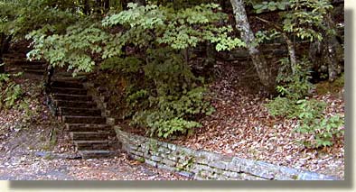
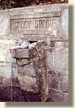
Once again we return to Sumter National Forest as we begin our accent toward the highlands in the Blue Ridge Mountains of South Carolina. After traveling a few miles, we come to Oconee State Park, a great retreat for picnicking, camping, hiking and other nature adventures. Climbing higher on State Highway 107, we come to a pull off on the west side of the road. Moody Springs, named for an original settlers who lived nearby. Colonel Wade Hampton II, hero of the Battle of New Orleans and the Mexican War often stopped here, on route to the "High Hamptons."
Climbing even higher on State Highway 107, we watch the "Upcountry's" lowland drop away to the east. The mountainous lands to the north and west are part of a three state wilderness of unspoiled land. Ellicott Rock Wilderness occupies space in the corner where South Carolina, Georgia and North Carolina meet. This 8,274 acre protected wilderness is for the serious outdoors adventurer. Hiking is the only accessible means to enjoy Ellicott Rock Wilderness. No motorized vehicles are permitted in the interior nor are bicycles or horses permitted.
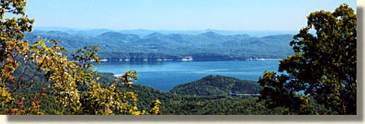
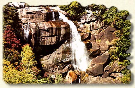
The Southern Highroads Trail is posted with green and white metal signs to help travelers know they're still on the trail. Right before we reach the South Carolina and North Carolina border the Southern Highroads Trail departs from State Highway 107 and takes a paved side road east, for a very short distance. The turn is well marked with a Southern Highroads Trail sign and directional arrow. This is Wigington Road, and it will take you to State Highway 130 north. Another sign will guide you at the intersection of Wigington Road and State Highway 130. The purpose for this route change is a spectacular waterfall. Whitewater Falls is easily accessed from the Trail, as well as an overlook of one of "Upcountry's" beautiful lakes, Lake Jocassee. Dukes Power Company operates this beautiful lake and waterway, its visitor's center offers tours of the hydro-plant's upper reservoir.
 Crossing
the state line into North Carolina, we immediately come to the exit for Whitewater
Falls on the east side of the highway. The trail from the parking
lot to the waterfall's viewing sight, is a 1/4 mile long. It's a paved
path with an easy grade for walking. The overlook allows for a full viewing
of the falls with a path to the left, that leads up to the top. There
is also a path to the right that will take you to the bottom of the falls.
Whitewater Falls is one the highest series of waterfalls in the eastern
United States. Whitewater Falls plunges 700 feet and continues over a
half a mile before it empties into Lake Jocassee. Don't miss this experience
and bring the camera, the walk is mild enough to be refreshing.
Crossing
the state line into North Carolina, we immediately come to the exit for Whitewater
Falls on the east side of the highway. The trail from the parking
lot to the waterfall's viewing sight, is a 1/4 mile long. It's a paved
path with an easy grade for walking. The overlook allows for a full viewing
of the falls with a path to the left, that leads up to the top. There
is also a path to the right that will take you to the bottom of the falls.
Whitewater Falls is one the highest series of waterfalls in the eastern
United States. Whitewater Falls plunges 700 feet and continues over a
half a mile before it empties into Lake Jocassee. Don't miss this experience
and bring the camera, the walk is mild enough to be refreshing.
After leaving the parking lot of Whitewater Falls, we continue to climb north into North Carolina. Over the North Carolina state line, State Highway 130 becomes State Highway 281. Continue traveling up and north on State Highway 281 until it intersects with US Highway 64, take US Highway 64 and go west.
Continue along the Trail as we cross over the South Carolina Border into Western North Carolina
![]()
Sign
up for the Blue Ridge Highlander Newsletter, Messages from the Mountains
to find out first about our new feature stories, road trips and special offers
Your e-mail addresses will not be sold or given away to anyone.
Privacy
Policy
Interested in your business being on the Highlander, click here...
Let our visitors tell you about the Highlander...
Click the feathers to go to the Highlander site
map...

Your e-mail addresses will not be sold or given away to anyone.
Let our visitors tell you about the Highlander...
Click the feathers to go to the Highlander site
map...
Highlander Special Interests
Great Mountain Attractions and Destinations Links to All Highlander Advertisers
Blue Ridge Highlander Mountain Emporium Art Gallery Photo Gallery Handmade Products Book Store
Magazine, Virtual Tours and Scenic Road Trips Creative Mountain Classes Just for Kids
Living Green and Eco Friendly in the Mountains Gardening in the Mountains Mountain Recipes
Mountain and Native American History Nathanael O. Smith - Storyteller Mysteries, Myths and Legends in the Mountains
Mountain Cathedral Charities and Fundraisers
Great Mountain Retreats
Adventure • Art • Cooking • Corporate • Family • Friend • Yoga • Wellness • Youth
Learn More About the Towns and Cities in the Mountains
North Georgia Mountains Western North Carolina Mountains
Up Country South Carolina Tennessee River Valley and Mountains
Great Smoky Mountains Blue Ridge Parkway
Move to or Invest in the Mountains
Real Estate • Log Homes • Cabins • Homes • Land • Acreage • Commercial Real Estate
North Georgia Mountain Real Estate Western North Carolina Real Estate
Tennessee River Valley and Smoky Mountain Real Estate
Interior Design and Furniture Shops Schools in the Mountains
Traveling • Living • Enjoying the Mountains
Log Cabin Rentals • Vacation Rentals • Resorts • Condos • Inns • Hotels • Bed and Breakfasts
Luxury Resorts and Spas in the Blue Ridge and Smoky Mountains
North Georgia Mountain Lodging Western North Carolina Lodging Tennessee River Valley Lodging
Plan a Mountain Wedding or Gatherings Conference, Meeting and Retreat Facilities
Vineyards • Wineries • Tasting Rooms Agri-Tourism Farmer's Markets
Yoga Retreats • Spas in the Mountains
Events and Festivals in the Mountains Theatre • Concerts • Mountain Entertainment
Restaurants, Dining and Catering in the Mountains
Shopping in the Mountains Blue Ridge Highlander Mountain Emporium and Art Gallery
Artists, Art Galleries and Art Associations in the Mountains Museums, History and Culture in the Mountains
Family Fun in the Mountains Just for Kids
Adventure and Outdoor Fun in the Mountains
Mountain Adventure Horseback Riding, Stables and Trails Mountain Bike Trails
White Water Rafting and Adventure Zipline • Canopy Tours Fishing in the Mountains
Boating and Marinas Camping and RV Parks ORV Adventures
Scenic Mountain Drives Mountain Golf Courses Mountain Day Use and Picnic Areas
National Parks in the Mountains National Forest Service in the Mountains State Parks in the Mountains
Waterfalls in the Mountains Lakes in the Mountains Rivers, Creeks and Trout Streams in the Mountains
Nature and Wildlife in the Mountains Mountain Birding Hiking Trails in the Mountains
More Information
Home Site Map Advertise on the Highlander Link to the Highlander Contact the Publisher
designed, produced and hosted by