
| Home | Sign up for Highlander Newsletter | Order Free Brochures and & More Info | Purchase Unique Gifts, Books, Photos & Artwork |
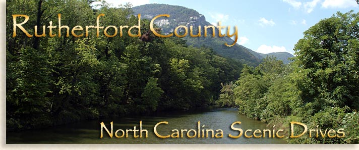
The Western North Carolina counties of the Blue Ridge Mountains have some of the most beautiful scenic drives any where in the country. Each county has its own distinct topography, natural beauty and local historical significance. The scenic landscape within the mountains and foothills are overflowing with natural and man-made wonders longing to be rediscovered time and time again.
Main highways, side roads, back roads, forestry roads and trails crisscross the mountainous regions delighting visitors as they find themselves drifting in and out of the countryside communities and towns while taking in historical and interesting sights along their journey.
Rutherford County in Western North Carolina has 3 popular driving tours that offer opportunities to discover the beauty of its mountains, foothills, lake, farmlands and river country, each sharing their own unique topography, communities and history. When driving through the county's far reaches always pick up a local county map and local brochures to help guide you along your chosen scenic driving tour.
Be sure to fill up your gas tank before you head out if your unfamiliar with the area, and always carry plenty of drinking water and snacks, you might be having such a great time along your tour discovering new things that you'll be gone longer than you expected.
Three popular driving tours in Rutherford County are: Cherry Bounce Trail, South Mountain Scenery By-Way and Drovers Road By-Way...happy motoring.
Cherry Bounce Trail

The Cherry Bounce Trail in Rutherford County, North Carolina is a mostly rural historic scenic driving tour that cruises through the central foothills, valleys and northeastern mountains of this remarkable and officially oldest governing body in far Western North Carolina. Featured along this auto sightseeing tour is the beauty of the county's landscape along with its impressive rural history of the Colonial settlers that predate the Revolutionary War along with other historical and more current events.
The trail was created and presented by the Isothermal Community College's Leadership Rutherford Class of 2006 to aid in the historical awareness of Rutherford County's diverse history for the enjoyment of visitors, local residents and the ancestral families who have made this their home for generations.
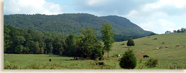
This historic by-way is laced with small towns and communities, textile mills, rural homes, farmlands, meadows, orchards, forest land, foothills, valleys, modest to larger sized mountains with the distant mountain ranges of the Blue Ridge bordering the north and west ends of the county. Today, much of the landscape looks as though it hasn't changed since the arrival of the Scot-Irish in the mid-1700's. Historical markers dot the roadside, marking the sites of significant historical events and there are plenty of these markers to checkout.

There are many places throughout Rutherford County where you can pick up a map for the Cherry Bounce Trail to help you along your drive. Most folks start in Rutherfordton, Forest City or Spindale. The trail follows several roadways that link together creating a type of circle from beginning to end. Following the map's directions along this historic trail will lead you through the largest and some of the smaller towns and communities the county has to offer. The journey will take you across the countryside where the foothills reach up to touch the sky, valleys roll up to meet a mountain's slope or flow outward across a low rolling landscape to meet the vast horizons to the east.
This driving tour will take you to many historical churches along the route from modest to grand in size and appearance. These houses of worship have been gathering points for generations of Rutherford County residents whose roots and commitments were to their faith, family and community here in far Western North Carolina.
The old Golden Church of the Brethren located along Cane Creek Road stands as a testament to a time long ago. This humble house of worship has a separated, two front door feature, one for the men and the other for the women members of the congregation. Some of these old rural churches would have large gaps between the floor boards for hardy frontier's men to conveniently spit their "chawin' tobacy" thru during Sunday services or community meetings while they held onto their seats during many a fire and brimstone sermon or heated political debates.
New homes in rural neighborhoods often reside near older homesteads creating a nostalgic look at Rutherford's past co-existing with their present.
Along the trail, tucked away in a rural tree covered setting, you'll find the Washburn House builtin 1913. Edgar Nollie Washburn built the striking, white columned, red-bricked Neo-Classical Revival House at a cost of just under $9,000. It has remained in the family for three generations, and is currently owned by Edgar Nollie Washburn, III (Edward) and his wife Catherine. The Washburn House is privately owned and not open to the public.
The Historic Washburn Village which includes the Washburn Home, the Barn and Washburn General Store were rightfully placed on the National Register of Historic Places in February 2002. The "stately presence" of this meticulously maintained estate is a regal example of the prosperous history within this rural farmland community.
The location of the Historic Washburn Village was originally a crossroads-trading center in the 19th century between Shelby and Asheville North Carolina and the city of Lincolnton and Rutherfordton, North Carolina.
Washburn is an old family name in Rutherford County, the Washburn General Store was established in 1831, and is a must see along the trail. It the oldest family business we have located in Western North Carolina, that is still in existence.
In our research we were able to contact Nollie Washburn Neill, Sr, Edgar's cousin which was kind enough to provide us with a little history of the family and estate, Nollie Washburn Neill, Sr writes....
Dear Highlander... Our Grandfather was the founder and President of Bostic Bank which he and others founded in 1915. The Washburn House was built from 1913 - 1915. It has 8 bedrooms, each with a fireplace. A few years ago my cousin's wife, Catherine found the ledger book that our grandfather kept of the construction of the house. The first entry was for $1.75, for gasoline for the Maxwell (auto) to go to Belmont, N. C. to see a house that was built in 1908 for a mill owner, before Grandfather Nollie ordered the plans from the architect in Baltimore. The little ledger books is a real treasure as it tells where each and every part of the house came from and specific information about how it was built. For example, the house has solid brick walls which are 18" to 20" thick. The facial brick on the home came from Tennessee. The maple floors came from New Hampshire. The outer walls were built that thick for durability. There is not a crack in the plaster and the pocket doors have not been touched since 1914 and still work perfectly. There is no pine lumber in the house, only oak and maple. And, the house was the first house to have electricity in the County. A small generator building was built to the right rear of the house with solid brick walls like the house. The generator could run the lights in store as well as the house. The generator house burned one time, after it was no longer used to make power, only the roof burned and this was easily replaced. My Mother loved to tell me how thrilled she was when she and her three sisters got to pick out the mantels for the fireplaces in their bedrooms. My mother was 8 years old when the family moved into their new home in 1915. I have the original photograph that the editor of the Forest City newspaper took in 1915 right after they moved in. The barn was built in 1915 and is in the location of their original home. The present Washburn General Store building which is the 4th building, was built in 1925. My cousin, Edgar Nollie Washburn, III (Edward) is the 6th generation to own the store. His children and grandchildren who work in the store on a part time basis, as needed, are the 7th and 8th generation to work in the store. Our State, North Carolina Public TV did a show on the Store in 2006. In their research they found that the store was the oldest family business in North Carolina, still in business. Our grandfather provided the land and one third the cost of the construction for the Salem Methodist Church in 1929 which is located across the road. My cousin Edward and I were Christened together on Oct. 29, 1932 in that church. The little red brick house next to the Washburn House was built in 1934 as a Funeral Home, but was never used for that purpose. At one time the House was used as a funeral home in the sense that only visitations were held in the house. My aunt, Mrs. Edgar Nollie Washburn, Jr. lived in the home until she died, as did my Grandmother, Mrs. Edgar Nollie Washburn, Sr. When our grandfather Nollie died in 1935 in New York city he had four country stores, the other three were in Sunshine, Bostic and one in the Pea Ridge area. Edward and Catherine have provided land for their three children and they all built homes and raised their families in the Washburn Village area and all of the grandchildren love to get married on the front lawn. For over 40 years we have had a family reunion on Mothers's Day. I've always lined up the entire Clan on the front steps of the House, after Church Services and a Covered Dish Dinner at Church and taken a family photo with a large format camera. Each and every family member that returns the next year gets a free 8 x 10 compliments of myself, Nollie Sr. and my wife Martha. My son Nollie, Jr. has now taken over most of the picture taking work, due to my old bones. Sincerely, Nollie Washburn Neill, Sr. |
Mrs. Highlander and myself would like to thank Nollie for his help, what a rare treat. There is nothing better than family history passed down, generation to generation, we feel privileged to have received your help...now back on the trail.
The upper north end of the Cherry Bounce Trail connects to the South Mountain Scenery By-Way for a few miles before heading southward again along the historic Cherry Bounce Trail tour.
As these two scenic by-ways temporarily join together at the northern end of the trail in the southern section of the South Mountains, they cross through "Golden Valley." The name Golden Valley was given to the area after the local gold-strike which began in the year 1828. Cherry Mountain, a local mountain in the region is one of the high peaks on the horizon and known for its abundance of wild cherry trees. After the gold rush and the Civil War, moon-shiners found this out of the way region of Rutherford County to be a relatively safe haven for the production of distilled liquors, one in particular was called Cherry Bounce, from whence the Cherry Bounce Trail takes its name. This popular livation was transported from the local mountains to as far away as the Mississippi River.
Just before the South Mountain Scenery By-Way crosses the northern county line, you continue to stay on the Cherry Bounce Trail by taking Cane Creek Road to Highway 64. A noted skirmish between the American Patriots and Loyalist Tories was fought on the old Cane Creek Road.
Highway 64 south along the Cherry Bounce Trail travels through some of the oldest settlements of the Scot-Irish in this region of far Western North Carolina. This southern route will take you through beautiful scenery and past some of the oldest well-maintained rural historic homes in the county and into Westminster, the oldest and still existing settlement in Rutherford County, which pre-dates the Revolutionary War. The area has both residential and farmlands, some of the old villages are still intact. Historical markers along the way tell the tales of early settlements, old forts and blockhouse sites that no longer exist.
In Westminster you will find the historic Brittain Church organized by the Presbyterian's in 1768. Today this historic and still active church stands as a symbol of a glorious past. The Brittain Church standing today is the third erected building constructed by the Presbyterian organization. It was built in 1852, nearly 100-years after the church's founding. This particular structure was brick-veneered in 1940. The nearly 250-year old site is one of the county's most significant historic sites and a true jewel in Rutherford County's rich heritage.
The Cherry Bounce Trail presents the county's historic past coexisting with its natural landscaped 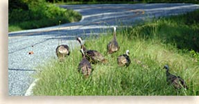 beauty. While driving along the trail you might have the privilege of spotting a stray fox foraging for vittles, a small herd of deer grazing in a field or a flock of wild turkeys out for a countryside stroll. You'll also find friendly folks along the trail happy to share local history with you. The numerous informative historical markers sites, public parks and hiking/biking trails will invite you to take some time off the roadway for a "shoes on the ground" first hand experience of what makes Rutherford County so special.
A morning, afternoon or early summer evening drive is all you need for this driving tour. The Cherry Bounce Trail is both enlightening and enjoyable.
South Mountain Scenery By-Way
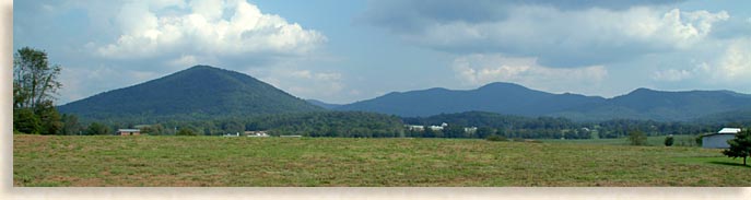
The South Mountain Scenery By-Way begins on highway 226. It is a 33-mile scenic drive through the foothills of the Blue Ridge Mountains. The central section of this scenic by-way travels through the lower southwestern section of the South Mountains in the northeast corner of Rutherford County's "Golden Valley" region. Though the by-way begins or ends (depending on what direction your coming from) from the town of Marion in McDowell County, North Carolina from the north and Polkville Cleveland County, North Carolina from the south. The heart of the scenic drive travels through Rutherford County's Golden Valley in the southern regions of the South Mountains which formally gives the scenic by-way its name.
This scenic by-way passes through low rolling foothills, orchards and rich farmlands before entering into the southern end of the South Mountains region. Golden Valley became a popular destination for opportunist when gold was discovered in the region in 1828. Though the main gold strike was short lived, some local gold mining was done well into the early 20th century. So many gold prospectors poured into the area when the strike first began that it required a branch post office to be established to serve the growing population. Today the old prospectors are pretty much gone although signs of their times and hobbyist prospectors still pan for gold locally as well as other regions of the Blue Ridge Mountains and Foothills. Skilled eyes can still catch a glimpse of gold dust and nuggets in the South Mountains while most amateur prospectors just enjoy the profits of fresh air and good exercise. So important was this gold strike that the Bechtler mint was established in Rutherford County to handle the precious minerals.
This historic area saw a few skirmishes during the Revolutionary War between American Patriots and Tories loyal to the British Crown, though the population was low due to its isolation. After the gold rush days came the Civil War, after that came the liquor wars between illegal distillers and revenuers. Moon shiners found this remote oasis of mountains, orchards and farmlands a great place to distill their illicit wares. One in particular was a drink called Cherry Bounce. Here at the southern end of the South Mountains seen just south of the South Mountains Scenery By-Way is a horseshoe shaped mountain range called Cherry Mountain due to the abundance of wild cherry trees along its slopes.
This mountain range was originally called Flint Kill until a colorful character and moon-shiner named Amos Owens, born in 1821, began producing the popular Cherry Bounce drink. This powerful drink made from corn whiskey, crushed wild cherries and honey was in demand as far away as the Mississippi River country. Owens was not  only popular with the drinking crowd he was highly sought after by local revenuers and well known in all the local county courts. His Scot-Irish grandfather fought in the Revolutionary War likely passing on hiswhiskey distilling talents to his offspring, creating a way of life for generations of rural mountain folks.
The various mountain landscape and the meadow lands in Golden Valley are picture postcard beautiful. This scenic by-way skims across the valley surface with mountains rising along either side of the roadway; little has changed the valley scenery since its early days of settlement. Today, Golden Valley is peaceful and serene, unique in its presence, an out of the way piece of God's County unlike any other. The decline and withdrawal of the gold rush prospectors and moon shine distillers have left behind in their wake a region rich in history returning the land to be an ideal mountain community filled with folks who wouldn't want to live anywhere else.
If you are looking for a secluded vacation getaway, retirement or relocation in a more laid-back slow-pace destination, Golden Valley offers the ideal setting away from the pressures of the 21st century world.
Unlike the roadways scaling the giants of the Blue  Ridge Mountains, the local South Mountains roads are less intimidating for those who are looking for beautiful mountain scenery with less altitude and fewer hairpin curves. The South Mountains are like an island composed of mountains floating in a sea of rolling foothills. These mountains are independent of the larger Blue Ridge Mountains to the north and west although they were once a part of the greater Blue Ridge Mountain Range. The South Mountains as they are called were not originally created independently from the Blue Ridge range but have been separated by eons of erosion creating its own unique mountain wilderness land. The First Broad River, which flows through Rutherford County, finds its headwaters here in the southern South Mountains before heading south into the open landscapes of North and South Carolina.
Bordering Rutherford County's Golden Valley to the north is the greater part of South Mountains where you will find the South Mountains State Park. The park was originally proposed in the 1940's, yet land for the state park wasn't purchased until 1974. The Civilian Conservation Corps (CCC) began working in the South Mountains region in the 1930's preparing the wilderness land for greater access. The South Mountains State Park and Wildlife Management Area presently consist of 18,000-acres of the over 100,000 total acres of the steep rugged South Mountains themselves. The summits of the South Mountains average between 1,200 to 3,000 feet above sea level, the parklands and surrounding areas offer lodging, camping, fishing, hiking, biking and more.
The South Mountain Scenery By-Way is a wonderful drive that takes about 45-minutes to drive each way. Allow plenty of time to check out the local history and communities along with the beautiful landscape. During your driving tour through the Golden Valley be sure to grab a bite to eat, see what the local shops have to offer or better yet, just rent a cabin and kick back for some well deserved time off, it's the best way to experience Golden Valley and the South Mountains.
Drovers Road By-Way

The historic Drovers Road By-Way travels through the mountain narrows along the floor of a steep river gorge as it winds along an ancient riverbed surrounded by wilderness beauty and natural wonders. From there the road ascends a mountain slope before crossing its gap and descending into the beautiful broad mountain valley interior of the Blue Ridge Mountains.
The Drovers Road; originally considered an early turnpike, is a natural access into the interior of the Blue Ridge Mountains for drovers who were moving livestock, mostly flocks of turkeys and some geese, herds of hogs and some cattle in and out of the mountains to the markets.
Officially the road is 10-miles long even though the interior mountain hub for market was in Asheville North Carolina to the north dating back to 1798. Standing at the crossroads in the heart of downtown Asheville is a giant obelisk monument dedicated to these hearty drovers who followed the Drovers Road with several statues of life size hogs and turkeys formed in bronze. It is one of the most important historic sights in the mountain city of Asheville, a city widely renowned for its historical sites and heritage.
The Drovers Road By-Way follows Highway 64/74A and passes along the southern shore of Lake Lure in Rutherford County North Carolina, traveling into the Hickory Nut Gorge below the monumental shoulders of Chimney Rock State Park. The by-way winds alongside the cascading white waters of the wild "Rocky" Broad River as it makes its way thru the mountain gorge.
At the eastern end of the Drovers Road By-Way, as you enter the mouth of the gorge is Chimney Rock at Chimney Rock Park, a towering pinnacle of solid rock giving the state park its name. Chimney Rock stands erect here as a natural monument greeting all who enter or exit the entrance of the gorge. This gateway was a welcoming site for those early frontiersmen and settlers who dared to enter and follow the "Rocky" Broad River into the forbidding reaches of the mysterious Blue Ridge Mountains. Here the scenic road by-way passes through the resort town of Chimney Rock Village along its journey. From the by-way below in Chimney Rock Village, you can witness the falling waters of the 404-foot Hickory Nut Falls descending from high above, an absolutely awe inspiring visual, one of the many wonders Chimney Rock at Chimney Rock State Park has to offer.
The Rocky Broad Riverwalk along the north banks of the "Rocky" Broad River in Chimney Rock Village offers an easy access to the white water river's natural boulders and cascading pools . The natural boulders scattered along the "Rocky" Broad River offers fly-fishing and pockets-of-fun for private swimming holes when rainfalls aren't too heavy for safe white water recreation. When accessing these and other white water courses and waterfall areas, the Highlander recommends that you wear quality made river sandals for safety sake.
Heading west a couple of miles you'll reach the junction of 64 and 74A, here you will find the community of Bat Cave known for its local "bat cave." Highway 64 turns southwest here heading for Henderson County while Highway 74A continues northwest along the old Drovers Road to Buncombe County and Asheville North Carolina.
Along the river and by-way you'll see several newer constructions, plus some historic looking buildings still in use while others are no more than homestead ruins from a time long gone. There are some unique shops along this route and a stately old Victorian home that seems out of place along this scenic by-way in the narrows of this wilderness country.
Due to the necessity of early travel along this essential route and the popularity of Chimney Rock and Lake Lure, the Drovers Road By-Way has seen a lot of historic traffic in its time. Today the by-way caters to tourists and local residents, yet its history is a testament to itself and the local region.
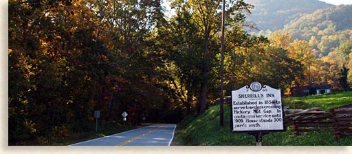
As the scenic by-way climbs north, bending and turning up the mountain slope to Hickory Nut Gap you'll find the historical site of the Sherrill Inn and Tavern located at the mountain gap. The Inn and tavern was an important stop over for travelers between the years 1834 to 1909. Bedford and Elizabeth Sherrill built the Inn after securing a mail contract between the towns of Rutherfordton in Rutherford County North Carolina and the city of Asheville in Buncombe County North Carolina. This historic mail-stagecoach line was named The Fly Cloud.
During the Civil War, Union soldiers commandeered the Sherrill Inn for a time. The site was headquarters for Union Army Colonel William J. Palmer, a commander of one of General George Stoneman's brigades. Colonel Palmer was not a party to one of General Stoneman's other brigades of recruits, which wrecked havoc in Rutherford County. A tragic wartime event that is locally known as "Stoneman's Raid." Colonel Palmer arrived in the area, the day after the Union raid on the town of Rutherfordton and apologized to the bereaved citizens of Rutherford County after finding out what the "Home Yankees," a group of southern volunteers who enlisted in the Union Army had done against what they considered were local Confederate sympathizers and innocent citizens.
Though kind in his words towards the citizens of Rutherfordton, the Sherrill family members who owned the Inn and tavern didn't appreciate the "gentlemen officer's" polite nature even though the Colonel was highly regarded and referred to as the "Quaker warrior." It is said that when feeding the Union officers at the Inn, one of the Sherrill family daughters had shaken her stocking over the eggs as they cooked and declared, "Those Yankees can eat the dust off may feet and think it's pepper." This lack of 4-star service could be considered understandable from a Southerner's point of view during the un-welcomed visitors' occupation of their remote Inn.
 The Sherrill Inn and Tavern is located 300-yards south of the historic marker along the Drovers Road By-Way at Hickory Nut Gap. During this time in history Hickory Nut Gap was known as Sherrill's Gap, named after the innkeepers. Heading north from the gap, Drovers Road By-Way winds and switchbacks down the northern mountain slope a relatively short distance where it accesses the broad Fairview Valley. The beauty of the valley is much the same as it has been for generations, the town of Fairview up ahead begins the outer edges of the city of Asheville's ever expanding metropolitan area.
 Just before the city of Asheville the Old Drovers Road crosses the renowned Blue Ridge Parkway along the valley road at the official end of the scenic by-way. From here the parkway heads up to the summit of Mount Mitchell, the highest point in all the Blue Ridge Smoky Mountains, but that's another tale and another scenic drive.
To reach the actual historic end of the old trail where the Drovers Road monument stands in Asheville, you take Interstate 40 west and exit at US 25 north which is also the Biltmore Estate exit. Then follow US 25 into downtown Asheville to witness the historic sight before returning to Rutherford County.
The historical heritage, mountains and valleys along with the breathtaking beauty of Hickory Nut Gorge, the Broad River and the indescribable wonders of Chimney Rock State Park, along with Lake Lure and its resort communities, make the Drovers Road By-Way a must-see when visiting this mountainous region of the Blue Ridge Foothills and Mountains.


Sign up for the Blue Ridge Highlander Newsletter, Messages from the Mountains
to find out first about our new feature stories, road trips and special offers
Your e-mail addresses will not be sold or given away to anyone.
Privacy Policy
Interested in your business being on the Highlander, click here...
Let our visitors tell you about the Highlander...
Click the feathers to go to the Highlander site
map...

Your e-mail addresses will not be sold or given away to anyone.
Let our visitors tell you about the Highlander...
Click the feathers to go to the Highlander site
map...
Highlander Special Interests
Great Mountain Attractions and Destinations Links to All Highlander Advertisers
Blue Ridge Highlander Mountain Emporium Art Gallery Photo Gallery Handmade Products Book Store
Magazine, Virtual Tours and Scenic Road Trips Creative Mountain Classes Just for Kids
Living Green and Eco Friendly in the Mountains Gardening in the Mountains Mountain Recipes
Mountain and Native American History Nathanael O. Smith - Storyteller Mysteries, Myths and Legends in the Mountains
Mountain Cathedral Charities and Fundraisers
Great Mountain Retreats
Adventure • Art • Cooking • Corporate • Family • Friend • Yoga • Wellness • Youth
Learn More About the Towns and Cities in the Mountains
North Georgia Mountains Western North Carolina Mountains
Up Country South Carolina Tennessee River Valley and Mountains
Great Smoky Mountains Blue Ridge Parkway
Move to or Invest in the Mountains
Real Estate • Log Homes • Cabins • Homes • Land • Acreage • Commercial Real Estate
North Georgia Mountain Real Estate Western North Carolina Real Estate
Tennessee River Valley and Smoky Mountain Real Estate
Interior Design and Furniture Shops Schools in the Mountains
Traveling • Living • Enjoying the Mountains
Log Cabin Rentals • Vacation Rentals • Resorts • Condos • Inns • Hotels • Bed and Breakfasts
Luxury Resorts and Spas in the Blue Ridge and Smoky Mountains
North Georgia Mountain Lodging Western North Carolina Lodging Tennessee River Valley Lodging
Plan a Mountain Wedding or Gatherings Conference, Meeting and Retreat Facilities
Vineyards • Wineries • Tasting Rooms Agri-Tourism Farmer's Markets
Yoga Retreats • Spas in the Mountains
Events and Festivals in the Mountains Theatre • Concerts • Mountain Entertainment
Restaurants, Dining and Catering in the Mountains
Shopping in the Mountains Blue Ridge Highlander Mountain Emporium and Art Gallery
Artists, Art Galleries and Art Associations in the Mountains Museums, History and Culture in the Mountains
Family Fun in the Mountains Just for Kids
Adventure and Outdoor Fun in the Mountains
Mountain Adventure Horseback Riding, Stables and Trails Mountain Bike Trails
White Water Rafting and Adventure Zipline • Canopy Tours Fishing in the Mountains
Boating and Marinas Camping and RV Parks ORV Adventures
Scenic Mountain Drives Mountain Golf Courses Mountain Day Use and Picnic Areas
National Parks in the Mountains National Forest Service in the Mountains State Parks in the Mountains
Waterfalls in the Mountains Lakes in the Mountains Rivers, Creeks and Trout Streams in the Mountains
Nature and Wildlife in the Mountains Mountain Birding Hiking Trails in the Mountains
More Information
Home Site Map Advertise on the Highlander Link to the Highlander Contact the Publisher
designed, produced and hosted by

of C. Wayne Dukes and Sherry Bell Dukes. 1996 - 2014, except where otherwise stated. All rights reserved, reproduction,
downloading, and/or duplication of any sort is strictly prohibited, all violations will be prosecuted. Legal Policy.
If you have any questions, or comments, regarding this site, e-mail the Highlander.