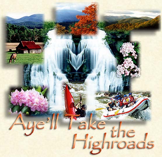
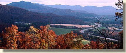
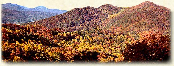
They rise against the heavens, creating a formidable wall, dominating the skyline with bold character, while echoing a past shrouded in mystery and intrigue. Older than myth, they endure time beyond imagination, creating an enigma of legend and culture. Reflecting a ray of sapphire light in one continuous line, these megaliths of astounding proportions have inspired and challenged man's attempt to be tamed. Since Colonial times, no other name has better described this eastern continental barrier than, "the Blue Ridge Mountains."
The mystique of the Blue Ridge Mountains is in its obscurity. It's like an island suspended by clouds forbidding to change, and struggling to be true to itself. At first glimpse of the great mountain ranges, you'll feel the big blue drawing you in, while all the long the "mountain spirits" are saying, "beware of the beauty we behold, it might just seduce you, and when it does, you will be ours forever."
Here lies a vertical retreat composed of nature's tender loving care, a land shaped by continental platte conflict, eons of water erosion and the fragile foothold of flora and fauna. An unparalleled world where progress collides with antiquity.
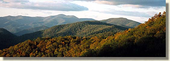
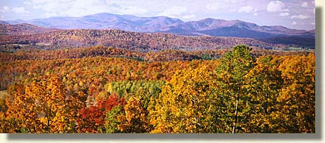
The southern highlands of the "Blue Ridge Mountains," encompass some of the grandest mountain ranges and most picturesque valleys, within the Blue Ridge Mountains Province. With mild winters and cool summer nights, the climate of the southern highlands is considered the perfect destination for mountain escape.
 The
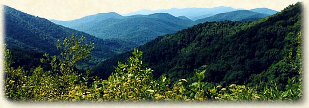
southern Blue Ridge Mountains are a world delicately scattered with cascading
waterfalls, dense hardwood forests, clear mountain lakes, swift running
streams and the carving force of whitewater rivers. Mountain peaks bear
the names of brave explorers as well as the names given to them by noble
ancestral tribes. There is bountiful wildlife indigenous to the land and
a flora symphony of color and fragrance characterizing the Blue Ridge
Mountains as..."no other place on earth."
The
southern Blue Ridge Mountains are a world delicately scattered with cascading
waterfalls, dense hardwood forests, clear mountain lakes, swift running
streams and the carving force of whitewater rivers. Mountain peaks bear
the names of brave explorers as well as the names given to them by noble
ancestral tribes. There is bountiful wildlife indigenous to the land and
a flora symphony of color and fragrance characterizing the Blue Ridge
Mountains as..."no other place on earth."
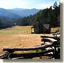 Man's
touch on the land has left a record with historical site markers posted
as lessons learned, or a way cleared and cornerstoned by a few courageous
souls. The development of roads from old Native American trails were the
first accessible routes into the mountains, with the further expansion
of mining and logging roads. These roads have given access to nearly every
acre of mountain land. Today, two and four lane roads crisscross the
mountain ranges and valleys, connecting towns that average a distance
of 10 to 30 miles apart. These paved highways are not only where life
flows for mountain residents and visitors, they are mountain lined avenues
of some of the most spectacular scenery the human eye can experience.
Man's
touch on the land has left a record with historical site markers posted
as lessons learned, or a way cleared and cornerstoned by a few courageous
souls. The development of roads from old Native American trails were the
first accessible routes into the mountains, with the further expansion
of mining and logging roads. These roads have given access to nearly every
acre of mountain land. Today, two and four lane roads crisscross the
mountain ranges and valleys, connecting towns that average a distance
of 10 to 30 miles apart. These paved highways are not only where life
flows for mountain residents and visitors, they are mountain lined avenues
of some of the most spectacular scenery the human eye can experience.
The roads in this part of the country are often named after the next town up the road, some are named after old trail blazers, and historical figures. Scenic routes like Russell-Brasstown Scenic Highway in Georgia, the Old Copper Road in Tennessee and various other Scenic Byways carry visitors off the main routes and into the wonders of the high country.
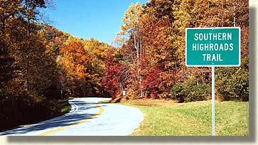
The Southern Highroads Trail...a popular route in the southern highlands saw its birth in the 1990's. The trail is an accumulation of several mountain routes forming a loop through four states, Georgia, North Carolina, South Carolina and Tennessee. The trail was designed for the visitor to start in any of the four states they choose and complete their tour in a circle, back to their selected point of entry.
The Southern Highroads Trail is a ribbon of asphalt, gently gliding across valleys and over mountain gaps, while occasionally following along the shore of a beautiful lake. We will cross the Appalachian Trail twice, zig-zag over the Eastern Continental Divide, do switch backs up and down mountain slopes, hug the curves of a high mountain gorge and ride the banks of a whitewater river rushing down a steep mountain gorge, all in one trip.
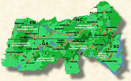
The
Southern Highroads Trail encompasses thirteen counties in four states.
 You'll experience each community with a quaint personality unique to its
view of mountain life and commercial heritage, both old and new. Boom
towns with old gothic courthouses claim the boundaries, while preserved
pioneer settlements and old homesteads mark the landscape. Patches of
grassy fields occasionally pop out of the forest. The crop here is mostly
live stock, with a little agriculture. For the most part, this is not
a land for farming although great for growing trees. Occasionally you
will see some good farm land, but not often.
You'll experience each community with a quaint personality unique to its
view of mountain life and commercial heritage, both old and new. Boom
towns with old gothic courthouses claim the boundaries, while preserved
pioneer settlements and old homesteads mark the landscape. Patches of
grassy fields occasionally pop out of the forest. The crop here is mostly
live stock, with a little agriculture. For the most part, this is not
a land for farming although great for growing trees. Occasionally you
will see some good farm land, but not often.
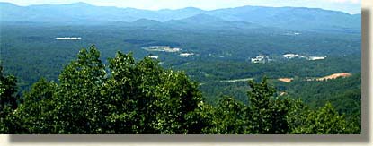
Hardwood forests canvas steep mountain slopes. Most counties have a 50/50 share between private land and National Forest. Some counties have more while others have a little less. The Southern Highroads Trail travels within 4 National Forests, the Chattahoochee in North Georgia, the Nantahala in Western North Carolina, the Cherokee in South Eastern Tennessee, and in Sumter in "Upcountry," South Carolina.
Click Map |
The Trail is 364 miles in length, or should I say encircled. There's no particular starting point which adds to its appeal. Its accessibility is determined by regional approach or metropolitan airports outside the mountains. There are only small air fields in the mountainous region. The Southern Highroads Trail can be a accessed within 90 minutes of four major metropolitan areas, Atlanta, GA, Asheville, NC, Chattanooga, TN and Greenville, SC. It is also approximately 45 minutes from a world renowned Great Smoky Mountains State Park. One thing I noticed traveling the entire Southern Highroads Trail, the pavement is outstanding, mostly due to great engineering, maintenance and the lack of heavy truck traffic.
For the sake of choice, lets access the Southern Highroads Trail via the largest metropolitan in the greater southeastern United States, Atlanta, GA. This is a great entry level route for those who are unfamiliar with mountain driving, the gradual ascent is not intimidating. Just north of the Atlanta metropolitan area you can pickup Interstate 575 going north. Interstate 575 eventually becomes State Highway 5/515 which will take us into Gilmer County Georgia, our journey's entrance into the Southern Highroads Trail. Gilmer County is at the threshold of the Blue Ridge Mountains' southern most geographical point.
 Known
as the "Apple Capital of the World," Gilmer County has mountainous
regions on three sides, ideal for back country recreation as well as a
large lowland valley in the center. This is perfect terrain and climate
for the vast apple orchards you'll find there. Fishing, boating and other
water recreation are a favorite of Carters' Lake in the southwest corner
of Gilmer County. Rich Mountain Wilderness and the Cohutta Wilderness
Area, are both located in the northern and eastern section of the Gilmer
County within the Chattahoochee
National Forest. Fresh water streams, waterfalls and hiking trails
thrive in the high mountain regions of these two mountain wildernesses.
Known
as the "Apple Capital of the World," Gilmer County has mountainous
regions on three sides, ideal for back country recreation as well as a
large lowland valley in the center. This is perfect terrain and climate
for the vast apple orchards you'll find there. Fishing, boating and other
water recreation are a favorite of Carters' Lake in the southwest corner
of Gilmer County. Rich Mountain Wilderness and the Cohutta Wilderness
Area, are both located in the northern and eastern section of the Gilmer
County within the Chattahoochee
National Forest. Fresh water streams, waterfalls and hiking trails
thrive in the high mountain regions of these two mountain wildernesses.
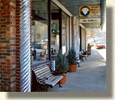
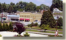
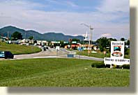
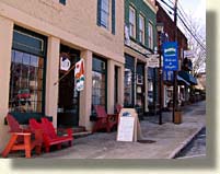
The Blue Ridge Highlander will begin its road journey on the Southern Highroads Trail in the bustling town of Ellijay in central Gilmer County. Ellijay became the catalyst of the late 1800's railroad expansion into the southern Blue Ridge Mountains. This wonderfully quaint town filled with antique shops, galleries, dining and a variety of lodging is brimming in historical sites and architecture.
The best way to describe Gilmer County is in the words and slogans of its own people. "So Appealing! Where winter is a mountaintop dusted with snow; spring is hillside layered with apple blossoms; summer is valley sprinkled with wild flowers and fall is a mountainside covered with a patchwork quilt of multicolored leaves."
We begin our first mile on the "Official Southern Highroads Trail" by picking up state highway 5/515 and US Highway 76 in Ellijay and proceeding north through Gilmer County.
The reason both the highway department and the railroad chose this particle route is the natural low terrain that enters the southern highlands through a path into the mountains known as the Murphy Syncline. This low trough begins in the marble quarries of Tate, Georgia, and runs through Gilmer County and into Fannin County, Georgia. Most notably, it divides two large mountain ranges creating an easily traversed doorway into the southern Blue Ridge Mountains. To the northwest you'll find the Cohutta Wilderness Area and to the southeast the Rich Mountain Wilderness.
The Rich Mountain Wilderness contains 13,276 acres of primitive back country and wilderness, great for the rugged backpack adventure. The Cohutta Wilderness Area is even more massive. It consists of 36,977 acres within a 95,265 acre Cohutta Wildlife Management Area, making the Cohutta the third largest wilderness in the eastern United States.
The Murphy Syncline trough spills out, or should I say, spills into a high mountain valley in Fannin County. Thus giving Fannin County the namesake..."Gateway to the Mountains." We entered the county through the town of Blue Ridge, Georgia. The county seat was originally in Morganton with progress giving way to Blue Ridge when the railroad came. The railroad hub brought attention to Blue Ridge as a resort town because of its promotion of the mineral spring health cures. Mineral springs were a very popular theme around the United States throughout the later half of the 1800's and early 1900's. Presently, Blue Ridge is a town of galleries, antique shops, dining and lodging.


Bordered by both Cohutta Wilderness Area and Rich Mountain Wilderness to the west and the Chattahoochee National Forest to the south, Fannin County is a mountain playground for sportsmen and women alike, with a nice laid back atmosphere of southern hospitality.
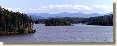
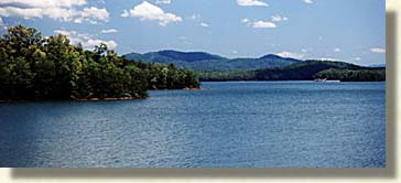 Lake
Blue Ridge, is a crystal blue water lake with a beautiful mountain backdrop,
its one hundred miles of shore is one of many mountain lakes created in
the 1930's by the Tennessee Valley Authority to control flooding. The
headwaters of the Toccoa and Ocoee Rivers find their origins here. The
Toccoa River in North Georgia becomes the infamous Ocoee
River once it crosses the border into Tennessee.
Lake
Blue Ridge, is a crystal blue water lake with a beautiful mountain backdrop,
its one hundred miles of shore is one of many mountain lakes created in
the 1930's by the Tennessee Valley Authority to control flooding. The
headwaters of the Toccoa and Ocoee Rivers find their origins here. The
Toccoa River in North Georgia becomes the infamous Ocoee
River once it crosses the border into Tennessee.
Leaving Blue Ridge, we continue on State
515 and US 76 due east. A few miles out of town, looking towards the north,
you'll find the big valley is scattered with smaller mountains. These
small mountains continue north until they cross over into North Carolina.
There, they run up against a wall of mountains called the Unicoi
Mountain Range. Looking back into Georgia, to the immediate south
is Duncan Ridge, a long range of mountain tops, 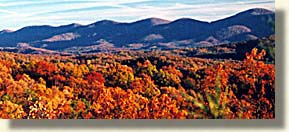 capped
by the Benton
MacKaye Trail and the Duncan
Ridge Trail. The Benton MacKaye Trail starts out on Springer Mountain.
You can also pick the trail up in the Cohutta Mountains at Double Spring
Gap near the Ocoee River in Tennessee.
capped
by the Benton
MacKaye Trail and the Duncan
Ridge Trail. The Benton MacKaye Trail starts out on Springer Mountain.
You can also pick the trail up in the Cohutta Mountains at Double Spring
Gap near the Ocoee River in Tennessee.
Crossing Sharp Top Gap on State 515 and
US 76, we enter Union County and catch our first glimpse of the eastern
wall of the mountains in the big valley. Known as the top of North Georgia
with Brasstown
Bald Mountain Range and Wilderness Area, towering at 4,784 feet.
To reach Brasstown Bald, you will have to leave the Trail. You can take
US 19/129 south to State  180
east, until you reach the Brasstown Bald entrance on the left. A paved
road will lead you almost to the mountain's peak. A steep 1/4 mile trail
leads you to the summit, a strenuous hike that can be made easy, if you
choose to pay for a shuttle van ride. The tower and observation platform
offer a magnificent 360 degree view, a view that will take you visually
around the Southern Highroads Trail, if you know where to look, and the
visibility is clear. From Brasstown Bald looking south towards Hogpen
Gap and westward to Blood Mountain you'll find a majestic area of mountain
trails, waterfalls, and illuminating flora displays. Ancient
180
east, until you reach the Brasstown Bald entrance on the left. A paved
road will lead you almost to the mountain's peak. A steep 1/4 mile trail
leads you to the summit, a strenuous hike that can be made easy, if you
choose to pay for a shuttle van ride. The tower and observation platform
offer a magnificent 360 degree view, a view that will take you visually
around the Southern Highroads Trail, if you know where to look, and the
visibility is clear. From Brasstown Bald looking south towards Hogpen
Gap and westward to Blood Mountain you'll find a majestic area of mountain
trails, waterfalls, and illuminating flora displays. Ancient  petroglyphs
can be found in Track Rock Valley. Native American tales and legends as
well as historical sites of early European Explorers, dating back nearly
five hundred years can be found throughout this area.
petroglyphs
can be found in Track Rock Valley. Native American tales and legends as
well as historical sites of early European Explorers, dating back nearly
five hundred years can be found throughout this area.
Back on the Southern Highroads Trail and to the north on 515/76 is Lake Nottely. You'll notice several channels of the lake's southern reaches before you reach Blairsville. One hundred and fifty miles of shoreline make Lake Nottely a favorite for boating, fishing and other water recreation. Union County has 97,800 acres of the Chattahoochee National Forest as a backyard playground for the land lovers.
 Just
before you enter the high range of mountains in eastern Union County you'll
enter the town of Blairsville, this county seat dates back to the gold
rush days. Coosa Creek in the mountainous terrain of southern Union County
has produced the finest caliber of gold ever found in the United States.
Just
before you enter the high range of mountains in eastern Union County you'll
enter the town of Blairsville, this county seat dates back to the gold
rush days. Coosa Creek in the mountainous terrain of southern Union County
has produced the finest caliber of gold ever found in the United States.
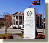
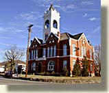
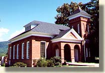
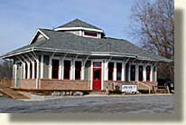
The old turn of the century courthouse is the center piece of Blairsville. As a part of the courthouse restoration, completed in the year 2000 is the beautiful, enormous clock tower that once adorned this historical site. The sharp rap of the gavel is no longer heard within the walls of the old courthouse, this building has been converted into a historical museum. Within Union County and Blairsville you'll find shops, galleries, dining and lodging.
Leaving Blairsville we also leave behind State Highway 515 and continue on US 76. You'll begin to follow a path into a more mountainous terrain. We now leave behind the four lane comfort and move into a two lane route that alternates from two to three lanes. There is one lane down grade and two lanes upgrade keeping the slower traffic to the right and a left lane for quicker moving traffic. After a few miles we'll pass over a gap between Ivy Log Mountain and a northern section of the Brasstown Mountain Range, the road then drops into Towns County.
Soon we'll come to one of the two towns within Towns County. Young Harris is a small mountain community and college town. The most valuable historical asset in this town is the old picturesque Young Harris College. The old historic campus buildings make this a rare and beautiful experience for visitors, students and faculty. From June through August, Young Harris College is the host of Georgia's Official Historical Drama, "The Reach of Song,'' performed at the Clegg Fine Arts Center. There are a few quaint shops, dining and lodging scattered across Young Harris Valley, with Brasstown Mountain Bald to the south, standing as a centurion guarding this mountain hideaway.

Traveling east on US 76 we now cross a
gap north of Cedar Cliff Mountain and behold the "Enchanted Valley."
As the highway drops before us you can't help but notice the mammoth mountain
ranges of the Nantahala
National Forest to the northeast. As we glide down the sloped
pavement, you'll begin to see the turquoise blue waters of Lake Chatuge.
Once you've enter the Enchanted Valley you will be overwhelmed by the
beauty. The entire center of the valley is 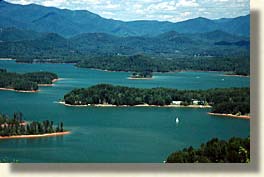 composed
of a 7,500 acre lake lined with forest, lake shore homes and completely
surrounded by high mountain peaks. To the south and east are the mountain
peaks of the Chattahoochee
National Forest with several access points onto the Appalachian
Trail. The mountains to the north, across the lake are the Nantahala
Mountains of North Carolina. We'll encounter the backbone of those mountains
later on the Southern Highroads Trail.
composed
of a 7,500 acre lake lined with forest, lake shore homes and completely
surrounded by high mountain peaks. To the south and east are the mountain
peaks of the Chattahoochee
National Forest with several access points onto the Appalachian
Trail. The mountains to the north, across the lake are the Nantahala
Mountains of North Carolina. We'll encounter the backbone of those mountains
later on the Southern Highroads Trail.
As we continue on US 76 we follow along the southern shores of Lake Chatuge. The lake flows north from Georgia into North Carolina. This section of Towns County is the heart of the North Georgia mountains.
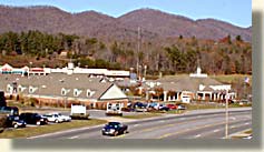
Hiawassee rests on the southeast shores of Lake Chatuge. Hiawassee has grown with popularity, you'll find shopping, dining, lodging and a concert theater that draws big named performers from the world of Country Music. Towns County has a vast array of activities from rugged back country to leisure time getaways.
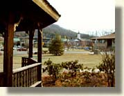
As we travel east, past Hiawassee on US 76, we come to the intersection of US 76 and State Highway 75 south. If you were inclined to leave the official Southern Highroads Trail for a short side trip. Go south on State 75, and you'll come the Bavarian Alpine Village of Helen. The trip there is a beautiful trek over rugged mountains, worthy of the drive.
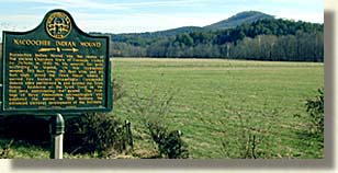
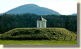
 This
section of White County has a unique history and geological wonders all
its own. The Nacoochee
Valley is scattered with historical markers describing the plight
of the original inhabitants as well as tales of pioneers and early European
explorers. There is also a very visible flat top earth mound where a Chief
Priest's temple home once stood.
This
section of White County has a unique history and geological wonders all
its own. The Nacoochee
Valley is scattered with historical markers describing the plight
of the original inhabitants as well as tales of pioneers and early European
explorers. There is also a very visible flat top earth mound where a Chief
Priest's temple home once stood.
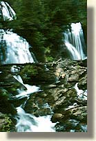
Anna Ruby Falls is also a must see, twin waterfalls from two creeks converge into one creek for a spectacular scene in Unicoi State Park just outside Helen. If you have the time, it's worth the trip.
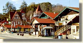
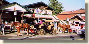
The town of Helen in White County, Georgia was once a considerably indistinct town. Drawing on the idea of bringing old world village designs from the Alps, to our beloved Blue Ridge Mountains, three developers came up with the idea of developing Helen into a Bavarian Alpine theme village. The town of Helen has charm and popularity, it has a lot of specialty shopping, dining, lodging, tubing, horse drawn carriage rides, and a mini amusement park.
Back on the Trail...following US 76 east from Hiawassee we pass through several small valleys before the terrain begins to grows steeper, Now is the time to practice constructive mountain driving. Tips for the road both useful and amusing.
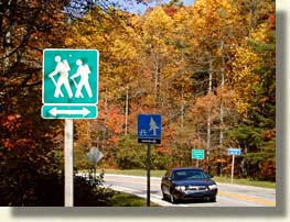 Near
the county line of Towns and Rabun Counties, on US 76 you'll reach Dick's
Gap and a crossing of the Appalachian Trail. There's a pullover here that
I highly recommend. The Appalachian
Trail is world renowned. Beginning at Springer Mountain in North
Georgia, this trail travels over the backbone of the Blue Ridge Mountains
in the
Near
the county line of Towns and Rabun Counties, on US 76 you'll reach Dick's
Gap and a crossing of the Appalachian Trail. There's a pullover here that
I highly recommend. The Appalachian
Trail is world renowned. Beginning at Springer Mountain in North
Georgia, this trail travels over the backbone of the Blue Ridge Mountains
in the 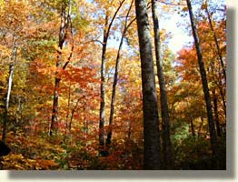 south,
to the Appalachian Mountains in the north finishing in Maine. This is
a trek of approximately 2,167 miles. Stopping at this pull over, gives
you a hair's touch and intimate view of this infamous trail. You can park,
hike up to the mountain and then return to your vehicle taking in the
opposite view on your trip back. Or, if you are not up for the hike, just
step out of the car, walk into the forest a few yards, breath in the high
mountain air, feel the tranquility and enjoy a picnic by the trail.
south,
to the Appalachian Mountains in the north finishing in Maine. This is
a trek of approximately 2,167 miles. Stopping at this pull over, gives
you a hair's touch and intimate view of this infamous trail. You can park,
hike up to the mountain and then return to your vehicle taking in the
opposite view on your trip back. Or, if you are not up for the hike, just
step out of the car, walk into the forest a few yards, breath in the high
mountain air, feel the tranquility and enjoy a picnic by the trail.
Continuing further east on US 76 we soon arrive in Rabun County, one of the most versatile mountain regions in North Georgia. Located in the far northeastern corner of the state, Rabun County has a unique geographical personality that is in contrast...as different as east meets west. The most significant difference is that Rabun County is on the east-side of the Eastern Continental Divide, where as the rest of North Georgia is on the west-side of the Divide.
Traveling a few miles into Rabun County we come to a very important overlook on the north side of the road. Here you'll behold stupendous views of mountain ranges and valleys. One of the unique experiences you'll find at a peaceful overlooks such as this one, is that the overwhelming beauty is so inspiring, you can't help but share a few kind words with other folks witnessing the same majestic wonders.
This is the upper part of the Tallulah Basin. To look upon its beauty, one would assume that this is untouched, virgin wilderness...quite the opposite. As far as the eye can see, this land was completely leveled by the logging industry in the early 1900's. The US Department of Agriculture obtained this wasteland and re-establish the wilderness with tree saplings to rebuild the forest and stop the erosion.
Deep within this land of spectacular gorges and waterfalls is Tate City, located in a high mountain valley. Tate City is remote, and was difficult to reach in its boom days. It originally was a mining community, turned logging camp. Today the reclamation of this region has seen the return of the black bear and some sightings of cougar. The wealth of Tate City today, is in its solitude and the lack of population. What was once a thriving center of commerce, has given way to an isolated community of a few picturesque residential settings and natural forest lands. Tate City is north of the Southern Highroads Trail, it's a special trip and another story for the Blue Ridge Highlander.
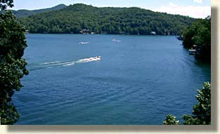 As
we continue east on US 76 for a few miles, we arrive at the northern shores
of Lake Burton. The beautiful sky blue waters of this secluded mountain
lake is its most appealing asset. Lake Burton. With its 62 miles of shore
line, Lake Burton is the uppermost and largest lake in a series of five
lakes along the Tallulah River. The other lakes flowing south of Lake
Burton are Lake Seed, Lake Rabun, Lake Tallulah and Lake Tugalo. Unlike
the mountain lakes on the west side of the Eastern Continental Divide,
which are operated by the Tennessee Valley Authority, these lakes are
operated by the Georgia Power Company.
As
we continue east on US 76 for a few miles, we arrive at the northern shores
of Lake Burton. The beautiful sky blue waters of this secluded mountain
lake is its most appealing asset. Lake Burton. With its 62 miles of shore
line, Lake Burton is the uppermost and largest lake in a series of five
lakes along the Tallulah River. The other lakes flowing south of Lake
Burton are Lake Seed, Lake Rabun, Lake Tallulah and Lake Tugalo. Unlike
the mountain lakes on the west side of the Eastern Continental Divide,
which are operated by the Tennessee Valley Authority, these lakes are
operated by the Georgia Power Company.
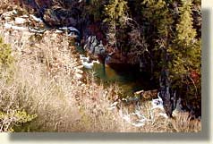 The
Georgia Department of Natural Resources formed a partnership with the
Georgia Power Company, to create the Tallulah
Gorge State Park. This state park is along the Tallulah River,
just below Lake Tallulah, in southern Rabun County. The spectacular Tallulah
Gorge, or chasm is two miles long. It has
cascading waterfalls and a scenic river, with
class 4-5 whitewater rapids. Its 650 foot deep, sheer granite and tree
lined walls can be viewed from the gorge's rim. For personal safety sake,
and the protection of Tallulah Gorge's delicate state of natural resources,
visitors to the park must obtain a permit from the visitors center, before
hiking into the gorge.
The
Georgia Department of Natural Resources formed a partnership with the
Georgia Power Company, to create the Tallulah
Gorge State Park. This state park is along the Tallulah River,
just below Lake Tallulah, in southern Rabun County. The spectacular Tallulah
Gorge, or chasm is two miles long. It has
cascading waterfalls and a scenic river, with
class 4-5 whitewater rapids. Its 650 foot deep, sheer granite and tree
lined walls can be viewed from the gorge's rim. For personal safety sake,
and the protection of Tallulah Gorge's delicate state of natural resources,
visitors to the park must obtain a permit from the visitors center, before
hiking into the gorge.
Another boast of Rabun County is Black Rock Mountain State Park, Georgia's highest state park. Black Rock Mountain takes its namesake from the sheer cliffs of dark granite. The park stretches over 3 miles along the spine of the Eastern Continental Divide.
Bartram Trail traverses the back country and mountain ridges throughout Rabun County's northeastern mountain region, including Ellicott Rock Wilderness, and into North Carolina.
Yet another noticeable attraction in Rabun County is Rabun Bald. At 4,696 feet it is less than 100 feet shorter than Brasstown Bald in Union County making Rabun Bald the second highest point in North Georgia.
Rabun County is known as the "Gateway to the Great Smoky Mountains," US 23/441 travels due north through the center of Rabun County. This route intercepts the Southern Highroads Trail at the junction of US 23/441 and US 76 in the town of Clayton in Rabun County, our next stop on our tour of the southern highlands.
Clayton is a classically beautiful mountain town, an old rail town with a main street lined with unique shops, galleries, dining and lodging. The town of Clayton has done a wonderful job of preserving its architectural heritage, balancing its older structures splendidly with its more recent development. There are several other notable towns in Rabun County although, our story of the Southern Highroads Trail now takes us further east and out of the state.


Back on the trail, at the intersection of US 76 and US 23/441 in Clayton, we'll need to turn south onto US 23/441 and travel about a quarter of a mile until we reach the intersection at US 76, our route does a little zigzag here. At the intersection of US 76 turn left going east, actually southeast according to the atlas. As we leave Clayton we journey back into the Chattahoochee National Forest and casually follow the winding country road to the banks of the Chattooga River. The Chattooga River forms the uppermost northeastern border of the state of Georgia and northwestern corner of South Carolina for approximately 40 miles, giving the river joint custody to South Carolina and North Georgia.
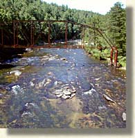 The Chattooga
River is a popular fishing destination and very popular river
with sections of both tame and wild whitewater rafting and kayaking as
well as canoeing, tubing, swimming, hiking and camping. The Chattooga
River is considered a crown jewel of the southern whitewater rivers. The
Chattooga River's class 4 and 5 rapids have earned it a "world
class'' status amongst rivers.
The Chattooga
River is a popular fishing destination and very popular river
with sections of both tame and wild whitewater rafting and kayaking as
well as canoeing, tubing, swimming, hiking and camping. The Chattooga
River is considered a crown jewel of the southern whitewater rivers. The
Chattooga River's class 4 and 5 rapids have earned it a "world
class'' status amongst rivers.
We exit the eastern banks of the Chattooga River at the corner boundaries of northwestern South Carolina and enter Oconee County. Continuing southeast on US 76 we enter South Carolina's beloved Sumter National Forests. "Upcountry," is the popular handle given to this region of the state by its local residents. "Upcountry" is a land of lakes, whitewater rapids, waterfalls, mountain wilderness, rolling farm lands and towns.
Continue along the Trail as we cross over the North Georgia Mountain Border into South Carolina
![]()
Sign
up for the Blue Ridge Highlander Newsletter, Messages from the Mountains
to find out first about our new feature stories, road trips and special offers
Your e-mail addresses will not be sold or given away to anyone.
Privacy
Policy
Interested in your business being on the Highlander, click here...
Let our visitors tell you about the Highlander...
Click the feathers to go to the Highlander site
map...

Your e-mail addresses will not be sold or given away to anyone.
Let our visitors tell you about the Highlander...
Click the feathers to go to the Highlander site
map...
Highlander Special Interests
Great Mountain Attractions and Destinations Links to All Highlander Advertisers
Blue Ridge Highlander Mountain Emporium Art Gallery Photo Gallery Handmade Products Book Store
Magazine, Virtual Tours and Scenic Road Trips Creative Mountain Classes Just for Kids
Living Green and Eco Friendly in the Mountains Gardening in the Mountains Mountain Recipes
Mountain and Native American History Nathanael O. Smith - Storyteller Mysteries, Myths and Legends in the Mountains
Mountain Cathedral Charities and Fundraisers
Great Mountain Retreats
Adventure • Art • Cooking • Corporate • Family • Friend • Yoga • Wellness • Youth
Learn More About the Towns and Cities in the Mountains
North Georgia Mountains Western North Carolina Mountains
Up Country South Carolina Tennessee River Valley and Mountains
Great Smoky Mountains Blue Ridge Parkway
Move to or Invest in the Mountains
Real Estate • Log Homes • Cabins • Homes • Land • Acreage • Commercial Real Estate
North Georgia Mountain Real Estate Western North Carolina Real Estate
Tennessee River Valley and Smoky Mountain Real Estate
Interior Design and Furniture Shops Schools in the Mountains
Traveling • Living • Enjoying the Mountains
Log Cabin Rentals • Vacation Rentals • Resorts • Condos • Inns • Hotels • Bed and Breakfasts
Luxury Resorts and Spas in the Blue Ridge and Smoky Mountains
North Georgia Mountain Lodging Western North Carolina Lodging Tennessee River Valley Lodging
Plan a Mountain Wedding or Gatherings Conference, Meeting and Retreat Facilities
Vineyards • Wineries • Tasting Rooms Agri-Tourism Farmer's Markets
Yoga Retreats • Spas in the Mountains
Events and Festivals in the Mountains Theatre • Concerts • Mountain Entertainment
Restaurants, Dining and Catering in the Mountains
Shopping in the Mountains Blue Ridge Highlander Mountain Emporium and Art Gallery
Artists, Art Galleries and Art Associations in the Mountains Museums, History and Culture in the Mountains
Family Fun in the Mountains Just for Kids
Adventure and Outdoor Fun in the Mountains
Mountain Adventure Horseback Riding, Stables and Trails Mountain Bike Trails
White Water Rafting and Adventure Zipline • Canopy Tours Fishing in the Mountains
Boating and Marinas Camping and RV Parks ORV Adventures
Scenic Mountain Drives Mountain Golf Courses Mountain Day Use and Picnic Areas
National Parks in the Mountains National Forest Service in the Mountains State Parks in the Mountains
Waterfalls in the Mountains Lakes in the Mountains Rivers, Creeks and Trout Streams in the Mountains
Nature and Wildlife in the Mountains Mountain Birding Hiking Trails in the Mountains
More Information
Home Site Map Advertise on the Highlander Link to the Highlander Contact the Publisher
designed, produced and hosted by