 Menu
Menu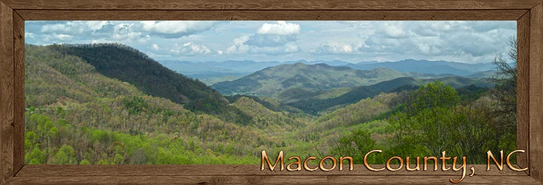
Highlands • Franklin • Macon County • Western North Carolina
Lodging • Cabin Rentals • Real Estate • Builders
Sapphire Valley is sizable valley of pristine beauty surrounded by high mountain peaks of bare granite. Money pays for mountain dreams here, roughing it is what the other guy does. Regardless of what you might think about material wealth, this particular high mountain country.
Highlands: you'll find the town to be top drawer, a beautiful town, door to door from one end of the street to the other. A multitude of antique and specialty shops, galleries, dining and lodgings.The Highland's area of Macon County is a 4,000 foot plateau with dominating mountain peaks of bare granite and heath balds summits. Two mountain tops in the area offer stupendous views, Whiteside Mountain and Satulah Mountain. Both mountain summits are accessible by short easy trails. You can reach Whiteside Mountain off US 64, between the town of Cashiers in Jackson County and the town of Highlands in Macon County.
Satulah Mountain can be reached by going south on State Highway 28 at the intersection of US 64 and State Highway 28. Satulah Mountain is unique because it is classified as a heath bald. The dwarfed white oak and dwarfed white pine on the summit can be as old as 200 years and no bigger then 10 inches in diameter.
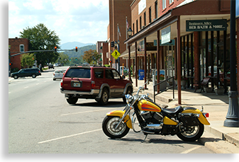
 In picturing the town of Highlands you'll have to imagine numerous daily visitors strolling up and down the streets in their designer wear. The business day ends and the town is still full of visitors, vehicles parked on both sides of the street with a double isle of vehicles parked in the center boulevard. Now imagine 90% of these vehicles as luxury sedans, foreign sports cars and top of the line Sport Utility Vehicles. The town of Highlands and surrounding communities have set precedence in luxurious mountain living. Ample parking is available, park and stroll the town, do a little shopping and take in good meal.....bon-appetite.
The Mountain Waters Scenic Byway covers some of the most spectacular sights Macon County has to offer.
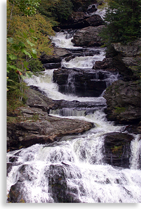
Beginning at the eastern end of the Lower Nantahala River at the junction of US 19/74 & HYW 28, this 61.3-mile byway heads westward through the river gorge along US 19/74. The byway turns southward along Wayah Road into Macon County up the Upper Nantahala River Gorge. There are numerous cascading waterfalls, past Nantahala Lake over Wayah Bald Gap and into the town of Franklin.
Once in Franklin, the Mountain Waters Scenic Byway picks up US 64 following the Cullasaja River Gorge into the high country past several sizable waterfalls. The first waterfall is Cullasaja Falls, at 250-ft in height. These falls are not accessible only, they can only be seen from the road.
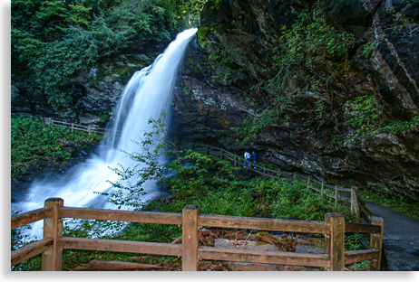 Now we move on to Dry Falls at 65-ft., Dry Falls offers a parking area and a short trail to this spectacular waterfall where the trail passes behind the falls overhang.
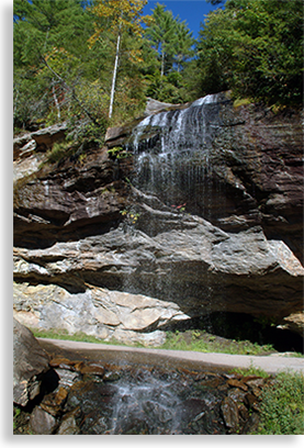 The next notable falls is right in the middle of the road, Bridal Veil Falls at 45-ft. Originally the waterfall divided the highway with traffic going around and behind the falls, today two lanes of US 64 pass in front of the falls with the old road still open as a pull off that goes under the falls. Further up US 64 is the modest size high mountain plateau Lake Sequoyah. A short distance from there is the Macon County town of Highlands.
Scenic route Hwy 28 also known as Moonshiner 28 begins near Deals Gap at the Tennessee/North Carolina state line and enters Macon County at its northern border where it follows the majestic cascading Little Tennessee River across the Little Tennessee Valley and into the town of Franklin where it joins US 64. From there US 64 & HWY 28 makes its way up the Cullasaja River Gorge past Cullasaja Falls, Dry Falls, Bridle Veil Falls past Lake Sequoyah and into the high mountain town of Highlands. This 105-mile long Moonshiner 28 ends its journey in the piedmont of South Carolina and into the piedmont of South Carolina.
Leaving the gorge, US 64 pours into the basin of lower Macon County, or more notably, the valley of the Cowee Gem Region. This area is a popular retreat for rock hunters throughout the world. Macon County is known as one of the world's three main locations for hunting gem stones, along with Burma and Thailand. This region of North Carolina produces Corundum and gem-quality rubies and sapphires from many mines scattered throughout the valley and mountain slopes.
Franklin: known as the, "gem capital of the world," is a sizable town by mountain standards. It is located at the crossroads of US 64 and US 23/441. US 23/441 is also the corridor route north to the Great Smoky Mountains.
The wealth of Macon County is not only in its mineral and logging yield, it also has a wealth of history. The earliest notable migration into the Southern Highlands by white settlers were the Scots. The Scottish Clans first migrated into the northeastern United States, and then began migrating into the southern Blue Ridge Mountains. It was the Scots that influenced the name, "Southern Highlands." The Scottish Tartan Museum is located in Franklin and can provide you with insight into the lives of the original "Highlanders."

Mining began here in the 1800's with progress following. Franklin was a rail town of substantial commerce. The downtown district is lined with old architecture and an impressive white marble Civil War Monument. Shopping, dining and a variety of lodging can be found in Franklin and surrounding Macon County. Several large chain stores and eateries are also located in the Franklin area.
Macon County to the east, completely surrounded by high mountain knobs and balds averaging over 5,000 feet above sea level. The mountains to the far east are the high peaks and balds of the Blue Ridge Parkway, to the north is the back bone of the Great Smoky Mountains. Our journey takes us west into the high remote tops of the Nantahala Mountains.
The cliffs and rock outcrops are botanical treasure houses showcasing the southernmost distribution of numerous rock-loving plants which need a combination of altitude, bare rock, and high rainfall to survive. These cliffs are excellent places to see peregrine falcons, ravens, and wintering golden eagles.
This region encompasses the headwaters of the famed Chattooga River and is the major northern access to the Ellicott Rock Wilderness. Streams such as the Cullasaja fall off the plateau in steep gorges. Waterfalls are frequent. Vistas of the Rabun Bald country and Blue Valley, now an experimental forest, are visible from NC 106, especially at the Osage Mountain, and Blue Valley overlooks.
Franklin Home Store
257 Crane Circle • Franklin, NC 28734 • 828.421.9008 • www.FranklinHomeStore.com
Scottish Tartans Museum & Gift Shop
Our gift shop features many unique Scottish gift items, including books, music, jewelry and more. We offer a full range of custom Highland Dress items to get you outfitted from head to toe. Every purchase helps to fund the museum!
86 E Main Street • Franklin, North Carolina, 28734 • 828.524.7472 • ScottishTartansMuseum.org


The Blue Ridge Highlander logo, all photography, design, graphics, artwork, writing, digital images, etc are the Copyright © of C. Wayne Dukes and Sherry Bell Dukes, 1996 to current day, except where otherwise stated. All rights reserved, reproduction, downloading, and/or duplication of any sort is strictly prohibited, all violations will be prosecuted. Legal Policy. If you have any questions, or comments, regarding this site, e-mail the Highlander.