 Menu
Menu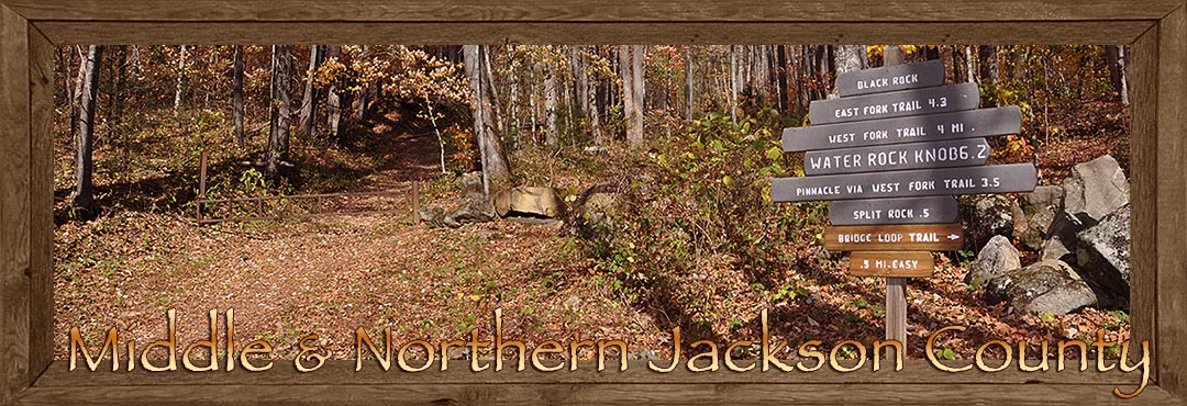
Waterfalls, White Water and Trails of the Middle and Northern Jackson County
and The Smoky Mountains Region
Unlike the geographically congested mountains and waterways of the ancient southern region of Jackson County's Blue Ridge Mountains, the middle to northern regions of Jackson County's Balsam and Smoky Mountains are bigger, bolder, and mightier than their more ancient neighbors to the south.
These younger mountains to the north reach some of the greater heights of the Blue Ridge Smoky Mountain Province and contain valleys and coves that accommodate the larger river waterways of both the Tuckasegee and Oconaluftee Rivers. Below are several points of interest within this geographical area fondly identified as the place "Where the Blue Ridge Meets the Smokies."
Judaculla Rock: This unusual site is located on private property, yet generously shared with a respectful public. It's an ancient site with a large soapstone slab carved with pictographs that defy translation even by local Native Americans. It is named after a fearful mythical giant named Judaculla. Legend has it that the markings on the stone were made when the giant leapt from his mountaintop home and landed on the stone alongside Caney Fork Creek, and there he left his mark. Some believe the markings may represent a boundary marker, others a battle commemoration or peace treaty. Maybe the marks are an incantation. Visitors to the site are welcome to form a conclusion of their own!The Judaculla Rock site is located in mid-Jackson County. Take Hwy 107 south from Western Carolina University to the town of East Laport. Just past East Laport, turn left at NC 1737, Caney Fork Road and go approximately 3 miles to Judaculla Road and then turn left. The site is at the end of the road about 1/2 mile, and located on private property. There is a parking area by the site and is open to a respectful public.
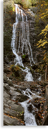 Mingo Falls: Mingo Falls are just what you would expect of a waterfall representing the Great Smoky Mountains--tall, secluded, majestic, and awe-inspiring. The falls are located on the southern edge of the Great Smoky Mountains National Park, in the parklands of the Qualla Boundary.
An excellent day hike would begin at the Newfound Gap access point and take a hiker up to Clingmans Dome, the highest point on the entire Appalachian Trail from Georgia to Maine. The hike from Newfound Gap to Clingmans Dome is 7 miles each way.
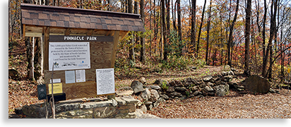 Pinnacle Park: Located just north of Sylva on the lower slopes of the Plott-Balsam Mountain is Pinnacle Park and Trail. The park, named after the jagged sharp-toothed ridgeline along the top of the mountain, gives a great view of the surrounding area. It's a 3 to 4 hour hike to cover the 6 to 7 miles up to the ridge top. Pinnacle Park is located at the dead end of Fisher Creek Road near the Old Asheville Highway.
Roy Taylor ATV Trail: It's definitely off the beaten path, and that's why it works. The Roy Taylor ATV Trail is located in the central eastern mountainous region of Jackson County, just northeast of Western Carolina University and the Cullowhee Valley. The trail is closed to ATV's from December 15th to March 15th but is open year-round for mountain biking, hiking, and horseback riding. This recreation area has thirteen challenging trails.
Overview of Jackson County North Carolina
The Towns in Jackson County
Sylva North Carolina
Cashiers North Carolina
Dillsboro North Carolina
Cullowhee Valley North Carolina
Whittier North Carolina
Glenville North Carolina
Webster North Carolina
The Small Towns and Communities of Jackson County
The Great Outdoors of Jackson County
Outdoor Adventure and Recreation in Jackson County
Waterfalls and Trails in Jackson County
River, Lakes, Streams and Waterways in Jackson County
Scenic Drives in Jackson County
Jackson County Scenic Driving Tours
Jackson County Special Assets...
Great Smoky Mountain National Park
Blue Ridge Parkway in Jackson County
Points of Interest along the Blue Ridge Parkway in Jackson County


The Blue Ridge Highlander logo, all photography, design, graphics, artwork, writing, digital images, etc are the Copyright © of C. Wayne Dukes and Sherry Bell Dukes, 1996 to current day, except where otherwise stated. All rights reserved, reproduction, downloading, and/or duplication of any sort is strictly prohibited, all violations will be prosecuted. Legal Policy. If you have any questions, or comments, regarding this site, e-mail the Highlander.