DeSoto Falls
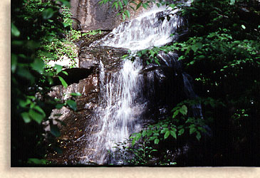
Legend tells of piece Spanish armor found near the falls that possibly belonged to explorer Fernando DeSoto or one of his men,  during their hunt for gold. DeSoto Falls consist of five waterfalls located within a 650-acre recreation area. Three of the five waterfalls are along hiking trails that are maintained for easy access. The lower falls cascade about 20 feet. The middle falls drop 80 feet and is considered to be the most scenic. The upper falls drop 200 feet down a granite rock incline. during their hunt for gold. DeSoto Falls consist of five waterfalls located within a 650-acre recreation area. Three of the five waterfalls are along hiking trails that are maintained for easy access. The lower falls cascade about 20 feet. The middle falls drop 80 feet and is considered to be the most scenic. The upper falls drop 200 feet down a granite rock incline.
Directions: Take U.S. 129 north from Cleveland, 15 miles till you reach DeSoto Falls Recreation Area.
Falls on Waters Creek and Blood Mountain Falls
Located on Blood Mountain Stream, the stream flows nearly 20 feet through a rock cut. Acting like a sluice, the waters from the stream rush through with a concentrated fury.
Directions: North from Cleveland on U.S. 19-129, approximately. 10 miles to U.S. 19, turn west on U.S. 19 approximately. 5 miles to Water's Creek Recreation Area and turn right. Drive 1.2 mile. and you'll pass a roadside waterfall on the right. Continue on another 1.6 mile. to the second waterfall and park in the lot to the right and take the path across the road for a more scenic view of the waterfall. Now take F.S. Road 34 for another .7 of a mile. to a logging road on the right before F.S. Road fords Crow Mountain Creek and park. The route to the waterfall treads along the logging road about .8 miles.
Helton Creek Falls
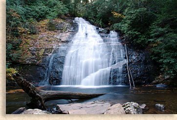
 The upper and and lower Helton are contained along a .3 mile trail. These falls are easy to reach. A well maintained trail follows the right bank of Helton Creek, along the extended drop of the lower falls, then comes to a dead end at the base pool of the spectacular 100 ft. vertical drop of the upper Helton Creek Falls. The upper and and lower Helton are contained along a .3 mile trail. These falls are easy to reach. A well maintained trail follows the right bank of Helton Creek, along the extended drop of the lower falls, then comes to a dead end at the base pool of the spectacular 100 ft. vertical drop of the upper Helton Creek Falls.
Directions: Take U.S. 129 south from Blairsville, 11 miles. Go past Vogel State Park and turn left on the first gravel road (distance from Vogel Park uncertain but more than a mile.) Go down gravel road 2.2 miles and you'll see a pullout parking area. The trail will be to the right.
Trahlyta
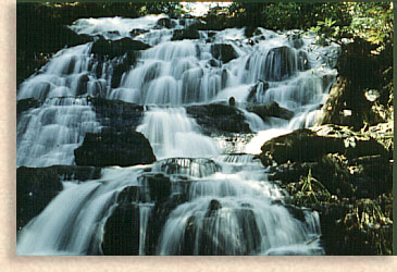
 Directly below Lake Trahlyta in Vogel State Park is a stepping stone waterfall. Go south from Blairsville, Union County Georgia on US 19/129 for eleven miles. Just before the entrance to Vogel State Park on the right is a one lane pullover where you can view the falls from above. Directly below Lake Trahlyta in Vogel State Park is a stepping stone waterfall. Go south from Blairsville, Union County Georgia on US 19/129 for eleven miles. Just before the entrance to Vogel State Park on the right is a one lane pullover where you can view the falls from above.
Directions: To reach the bottom of the falls, drive into Vogel State Park and park at the south end of Lake Trahlyta, there's also a gift shop and miniature golf course plus campgrounds and cabins. The fall are at the other end of the lake, the lake is small and the paths around each shoreline is level. If you take the path to the left you'll pass the pavilion and Trahlyta Theater then the beach and beach house following the Trahlyta Lake Trail to the end of the lake and take the Falls Overlook trail to the bottom of falls.
Trahlyta Lake Trail also flows to the right of the lake. This is a quiet trail with the lake at the edge with beautiful views of the lake and surrounding mountains. When you reach the end of the lake take the Falls Overlook Trail to the right and follow the trail to the bottom of falls. The trail is short but steep but worth the effort.
Printable
State • Town • City • County • Guide
If you would like to know what towns are in which county,
use these printable pages to find out.
North Georgia Mountain • Printable City and Town Guide
Other Blue Ridge Smoky Mountain Waterfalls
Waterfalls in the North Georgia Mountains
Waterfalls in Western North Carolina Mountains
Waterfalls in South Carolina Up Country
Waterfalls in Tennessee River Valley and Mountains |

 during their hunt for gold. DeSoto Falls consist of five waterfalls located within a 650-acre recreation area. Three of the five waterfalls are along hiking trails that are maintained for easy access. The lower falls cascade about 20 feet. The middle falls drop 80 feet and is considered to be the most scenic. The upper falls drop 200 feet down a granite rock incline.
 The upper and and lower Helton are contained along a .3 mile trail. These falls are easy to reach. A well maintained trail follows the right bank of Helton Creek, along the extended drop of the lower falls, then comes to a dead end at the base pool of the spectacular 100 ft. vertical drop of the upper Helton Creek Falls.
 Directly below Lake Trahlyta in Vogel State Park is a stepping stone waterfall. Go south from Blairsville, Union County Georgia on US 19/129 for eleven miles. Just before the entrance to Vogel State Park on the right is a one lane pullover where you can view the falls from above.


