 Menu
Menu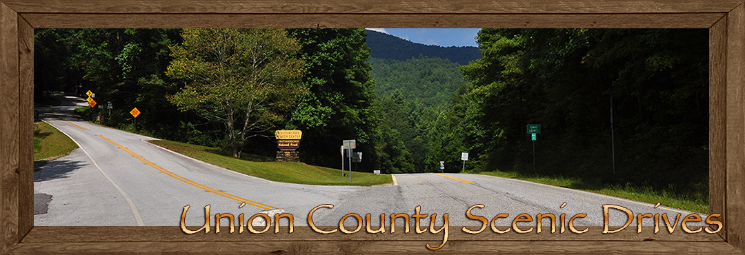
Scenic Drives in Union County ~ Blairsville & Suches Georgia
Driving tours are probably the most popular way to see and experience the beauty and wonders of these ancient Blue Ridge Mountains. Union County not only has natural beauty it also has some of the finest highways and road systems the Blue Ridge Mountains have to offer.
Heading south from Blairsville on US 19/129 you'll come to the junction where 19/129 south and GA 180 east meet. A short distance ahead you will begin to follow the eastern fork of Wolf Creek as it winds its way to the junction of US 19/129 and GA 180 heading southwest. This junction is at the northern end of Vogel State Park turn right onto GA 180.
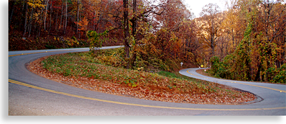 Vogel State Park to Suches: GA 180 winds along the western shoreline of Vogel Park’s Lake Trahlyta for a short distance before climbing higher with each turn as you cruise along this narrow but smoothly pave two-lane road. One of the great features of this road is the long hairpin switchback turn that you’ll come to up ahead. This first section of GA 180 reminds me of the popular road in North Carolina called the "Tail of the Dragon," a roadway that travels 11 miles with 318 curves.
This section of GA 180 from Lake Trahlyta to the big hairpin switchback is only a couple of miles long and has many tight curves along the way. The Highlander has dubbed it the "Little Dragon Tail."
Pass the hairpin curve and continuing up the grade you will soon reach the Sosebee Cove Scenic Area. Parking is located alongside GA 180 on the right, through gaps in the trees you’ll see glimpses of Cooper's Creek Scenic Area, the views from here are most dramatic in late fall and winter.
The cove is located on a 175-acre land tract with a hiking trail on the lower side of the highway and a boulder field on the upper side of road. This moderate class, 3/10 of a mile hiking trail is made up of two linked loops that will take you into a hardwood forest with a stream flowing thru the heart of the cove. This is a very nice location to stretch your legs and enjoy a fresh mountain air experience for your nature lovers.
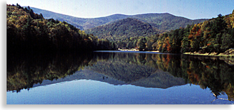
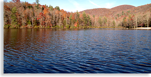 Continuing on GA 180, you will soon arrive at the Lake Winfield Scott Recreation Area. A parking lot on the left will place you along the shores of this pristine 18-acre lake. This hidden jewel is a great place to stop and enjoy a picnic and a short hike. The steep mountaintops surrounding the lake provide a beautiful reflecting pool view with mountains rising upward touching a powder blue sky. The hiking trail circles the lake with a pavilion on the opposite shoreline. The Winfield Scott Recreation Area also offers camping, swimming, fishing, boating and canoeing, only electric motors are allowed on the lake to maintain the purity of the lake waters and quiet solitude.
Lake Winfield Scott was name after General Winfield Scott who had the unpleasant duty of overseeing the removal of the Cherokee People in the 1830's just prior to their infamous "Trail of Tears" journey to Oklahoma.
When leaving Lake Winfield Scott Recreation Area, exit the parking area at GA 180 and turn left, leaving the winding road behind for a while and entering the high mountain valley lands of Suches. The tranquility of this valley is due to its isolation; modest changes have held this region in a pristine state, there’s a gas station up ahead with little to no other commercial businesses in the area.
At the upper end of the valley GA 180 ends and intersects with GA 60, a right turn will take you to the historic Woody Gap School which is still in use today. A left turn off GA 180 and onto GA 60 will take you up to Woody Gap, it's only a short distance up the road for a special treat. At the gap there are two parking areas on either side of the road. The one on the right has an outstanding view of Yahoola Valley and the lower lands of northern Georgia. The Appalachian Trail crosses Woody Gap here at the parking area; a short hike along the trail on either side of the road will credit you with a personal experience and the claim to have hiked the Appalachian Trail even if it’s only for a short distance.
 The first North Georgia gold strike took place just beyond Woody Gap in Lumpkin County. Exit the parking area and head back down GA 60 north to GA 180. The trip-back to Vogel State Park will be just as exciting, offering an opposite directional mountain view along this scenic driving tour.
Reaching the intersection of GA 180 and US 19/129 turn right, you’re now headed towards Vogel State Park. The entrance is just a short distance ahead, before you reach the entrance to the park be on the lookout on the right side of the road for Lake Trahlyta Falls, one of Union County’s tallest waterfalls. The view from the road is a downward view of the waterfall. There’s a shoulder pull off on the right side of the road for this popular waterfall overlook.
Lake Trahlyta is above the falls feeding its overflow downward over a series of falls to the eastern branch of Wolf Creek below. The viewing deck located near the bottom of the falls is only reachable from within the park.
 Vogel State Park entrance is located on the right side of 19/129 just past the falls; a lakeside approach road will lead to the parking area on the upper end of the lake.
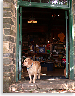
Next to the parking area is the Welcome Center gift shop, next to that a miniature golf course and the cascading waters of Wolf Creek before it flows into the lake. Vogel State Park is definitely worth the visit, it is Georgia’s most popular state park and was named one of the nation's 25 most popular state parks by Camping Life Magazine.
Behind the Welcome Center there are up to 110 camping sites; located in the park you'll find an additional 36 guest cottages. There are approximately 17-miles of hiking trails including a moderate hiking trail around the lake. At the opposite end of the lake is a short trail that leads to the observation deck at the bottom of Lake Trahlyta Falls, this is the same falls viewed from the road. The trail is a short moderate to strenuous hike and well worth the trip to the observation deck at the bottom of the cascading waterfall.
Lake Trahlyta has a very nice beach-front for swimming and a bathhouse. Paddle boats are available for a modest price and the lake is stocked with trout. There are picnic tables and picnic shelters, grills, restrooms and hot showers, a playground and the Pavilion Trahlyta Theater with displays of the Civilian Conservation Corps (CCC) who worked for the Forest Service developing Vogel State Park. Take the time to experience Vogel State Park; you will enjoy your time spent.
Vogel State Park to Neel's Gap: Leaving the state park turn right on US 19/129 and continue up the highway into the Chattahoochee National Forest. As you begin to climb Blood Mountain watch for Helton Creek Road and turn left, you’re now headed towards Helton Creek Falls, a trip definitely worth the drive.
Helton Creek Road passes several cabins before it leaves the pavement and becomes gravel. The gravel section of Helton Creek Road is a forestry road that winds downward. The road is a little tight so go slow, there are many curves and possible opposite traveling traffic passing snuggly by one another, any vehicles bigger than a standard SUV or full size pickup truck should avoid this journey, average size cars can easily make this trip.
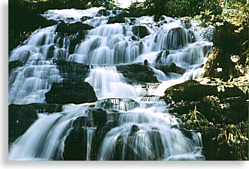
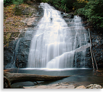 After about a mile and a half you’ll reach a parking area on the right. The falls are close enough that you’ll be able to hear the rushing water when you exit your vehicle, and the falls are partially visible from the road. Upper Helton Creek Falls trail is only 2/10ths of a mile long, a moderate hike. Lower Helton Creek Falls is also accessible from the trail.
It’s recommended to exercise caution by the lower falls, slippery rocks can lead to unforeseen accident; beauty from a distance is safer than a fall down the rocky sides of Helton Creek.
Upper Helton Creek Falls and its large catching pool are just a few more yards up the trail; an observation deck in front of the falls offers the best view. This is one of the most beautiful falls in the North Georgia Mountains and well worth the forestry road adventure.
Traveling back to US 19/129, turn left and continue your upward journey. By now you will have noticed the superb engineering of this particular roadway. One the finest examples of engineering makes US 19/129 probably the most enjoyable mountain driving experiences you'll have in the North Georgia Mountains. This two and sometimes three lane roadway up the steep northern slopes of Blood Mountain and down the other side is a driving marvel, rival to any other mountain drive in the United States.
The one thing you'll discover driving the back roads as well as the main routes of Union County are their well maintained paved roadways. Constant care and maintenance for roadways is a signature of Union County.
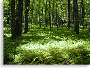 Back on US 19/129 you continue your incline drive up Blood Mountain till you reach the Bryon Herbert Reece Memorial Park on the right side of the road. This short horseshoe shaped road off 19/129 will take you into a high mountain cove. This is a quiet setting with no recreation. This memorial dedicated to a local writer of international fame is an emerald green wonderland in the spring and summer, ground coverings of ferns with a translucent green leaf canopy supported by tall columned of trees. Here you’ll find is quiet solitude and the Reece Access Trail that travels up 8/10ths of a mile, connecting the Byron Herbert Reece parking area with the Appalachian Trail over Blood Mountain.
Completing the memorial park’s short horseshoe drive you’ll return to US 19/129 and turn right, drive 1/2 mile more and you will reach the the top point of this mountain driving tour and the historical Neel’s Gap. The parking area on the left is for the Walasi-Yi Interpretive Center. This historic stone building, built between 1934 and 1938 has been placed on the National Register of Historic Places. Constructed by the Civilian Conservation Corps (CCC,) the structure was created using native stone.
During his administration, President Franklin D. Roosevelt formed the CCC during the Great Depression era, as part of his presidential “New Deal” plan, conceived to provide jobs for out of work Americans. Thousands were employed living in wilderness camps, providing skills and labor for the forest service, using raw materials for structures, building trails, bridges, roads and planting trees.
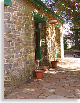 The Walasi-Yi Center is open to the public and houses a gift shop a convenient stop over for drivers and hikers using the Appalachian Trail which crosses Blood Mountain here at Neel’s Gap. The center provides some necessities for the hikers as well including restrooms, showers and a laundromat.
Located at the southern end of the center is a stone balcony overlooking the southern mountain slopes with views into the lower foothills of both Lumpkin and White County Georgia.
At the very bottom of the southern slopes along the right side of US 19/129 is DeSoto Falls Recreation Area, if you’re interest in a little additional side trip. The falls are not visible from the parking area; a 1/2 mile moderate hike along the Frogtown Creek leads to the larger waterfall.
Legend tells of someone finding a piece of mid-16th century Spanish armor near the falls, giving some credence to its name. It’s possible the conquistadors might have taken this trail over the gap and into the mountain interior searching for gold. DeSoto’s journals do tell of reaching a Native American village to the north near Murphy, North Carolina next to the town of Peachtree.
On the northern end of Walasi-Yi Interpretive Center, connecting the larger stone structure on the southern side to a smaller stone building on the northern side is a covered breezeway. This covered breezeway is unique because it is the only man-made covered structure to be found on the entire Appalachian Trail which stretches 2,135-miles from Springer Mountain Georgia to Maine.
 The popular day hike here is the 2-mile trip up to Blood Mountain’s summit at 4,458 feet above sea level, a steep and vigorous hike yet a worthy journey if you’re up to it. It’s slow going so pack a snack, be sure to take plenty of water and allow for plenty of time. Also, be prepared for possible sudden changes in weather, high mountain ridges can be unpredictable. If you plan to hike this trail it’s necessary to go back to the parking area at Bryon Herbert Reece Memorial Park, there’s only limited parking for guest of the Walasi-Yi Interpretive Center.
Blood Mountain seems like a harsh name, so does its neighboring Slaughter Mountain. The Cherokee and Creek legends tell of a great battle between the two nations for dominance of this mountain region. A fierce battle fought in Slaughter Gap between Slaughter and Blood Mountain.
I’m not sure who won this battle, as the tale states the battle was so vicious that the upper waterways ran with blood down the northern slopes to the area of Lake Trahlyta near the bottom of Blood Mountain.
Lake Trahlyta acquired its name from a Cherokee princess who knew of the guarded secrets of a magical spring from the Witch of Cedar Mountain which is located on the southern side of Blood Mountain. The springs offered eternal youth to those who knew and kept its secrets. If you are interested in the rest of this story you'll want to read the Highlander feature “Gold City Tour.”
If the tale of Blood Mountain isn’t macabre enough for you, check out the brass plaque near the Walasi-Yi Center where the Appalachian Trail passes through the center’s breezeway, it’s otherworldly to say the least. The plaque states; In Cherokee mythology the mountain (Blood Mountain) was one of the homes of the Nunnehi or Immortals, the “People Who Live Anywhere,” a race of Spirit People who lived in great townhouses in the highlands of the old Cherokee Country. One of these mythical townhouses stood near Lake Trahlyta. As a friendly people they often brought lost hunters and wanders to their townhouses for rest and care before guiding them back towards their homes.
Neel's Gap to Richard Russell Scenic Byway: Leaving the Walasi-Yi Interpretive Center, head northward on US 19/129 back down Blood Mountain, you’ll pass Vogel State Park and pass GA 180 on the left; continue on 19/129 north until you leave the foot of Blood Mountain behind. Here you will reach the southern end of the central valley lands of Union County, US 19/129 north will soon intersect GA 180 east. Turn right onto GA 180 for the next section of this Highlander Scenic Tour.
You’ll quickly cross over the Nottely River, go about a 1/2 mile to Richard B. Russell Scenic Highway on the right, turn right at the intersection and go south onto the scenic highway. This 14.1-mile scenic byway will take you along the Nottely River as it winds through a long narrow valley. At the end of this picturesque valley you’ll begin your climb up the paved mountain slope.
You’re now back in the Chattahoochee National Forest winding upward thru thick lush greenery. The roadway view opens up on the left exposing mountain tops as this scenic highway takes on a steep straight roadway, climbing upward, you will feel the power train of your vehicle pulling against the grade.
Two gaps 1/2 mile apart lay at the top of the grade. The first gap you arrive at is the old Tesnatee Gap there’s a parking area on the right at the gap. Tesnatee, was used by the earliest white settlers crossing into the Blue Ridge Mountains following the old Logan Turnpike. The old turnpike descends down along the upper headwaters of the Nottely River, the road is rugged and unpaved and not a part of this tour.
 From the parking area you’ll find access to several hiking trails, one will take you down the southern slope of the mountain gap along a section of the old Logan Turnpike Trail. You can also access the Wildcat Mountain Whitley Gap Trail and the Adams Bald Trail by using the Appalachian Trail that crosses the Tesnatee Gap.
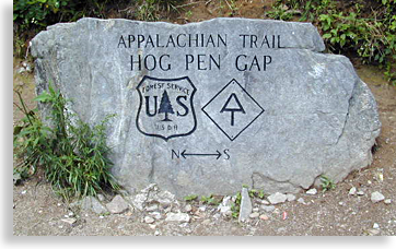
You can also continue up the Appalachian Trail about a 1/4 to 1/2 a mile to the next higher gap crossing at Hogpen Gap. For an easier journey you can exit the parking area, turn right and drive to the gap instead of hiking. Before exiting the parking area notice the impressive hairpin turn along the edge of the parking area and the beautiful mountain vistas towards the right. The short climb along Richard Russell Scenic Highway is steep but the slow going will give you a chance to see the vista's and layers of big mountains as the valley drops away to the left. A sheer wall of banded gneiss (metamorphic rock) on the right of the roadway displays its wavy bands, an ancient view of hot rock cooled along the outer surface of the mountain.
At the top of the grade is Hogpen Gap, there’s a parking area on the left with a panoramic view of Union County. Once again the Appalachian Trail crosses paths with your journey. Hogpen Gap divides Union County and White County to the south.
If your looking for a little side trip, Richard B. Russell Scenic Highway descends from the parking area at Hogpen Gap southward with several overlooks of the piedmont of northern Georgia to the south and the lone and sheer rock face of Yonah Mountain on the horizon. About half way down the winding scenic highway is Raven Cliffs Wilderness Area where you’ll finds numerous trails and waterfalls. Dukes Creek Falls is viewable from an observation deck near the parking area. The Richard B. Russell Scenic Highway comes to an end when it intersects Alternate State Highway 75 just outside Helen in White County Georgia.
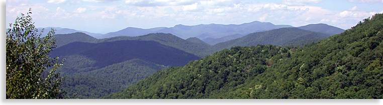
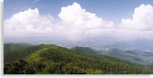
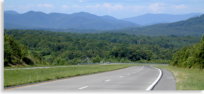
Back at Hogpen Gap, looking at the magnificent mountain view to the east, with its layers of mountains rising to the highest point along the longest mountain range on the horizon, you will notice the impressive bald at the ridge’s highest point in the photo above. That is Brasstown Bald and Brasstown Bald Wilderness Area. In recent years that grand summit has inspired a vision that would turn the original Richard B. Russell Scenic Byway into the Russell-Brasstown Scenic Byway extending this previous 14-mile scenic highway all the way to the top of Brasstown Bald on the distance horizon.
 Hogpen Gap to Brasstown Bald: To reach that distant peak, return back down the mountain heading northward. The road grade you came up on, is the same steep grade going down. I put my automatic transmission in 2nd gear or one below Drive to save on excessive braking. Once you reach the bottom return the transmission to Drive. Overdrive saves gas on level roads but it pulls weak going up grades and doesn’t hold the engine back like Drive and 2nd gear.
Once you’ve reach GA 180 turn right going east and follow GA 180 for about 5-miles or less to the entrance of Brasstown Bald at Jack’s Gap, the entrance is on the left.
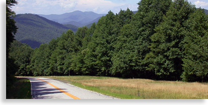
The paved approach road winds upward where treetops disappear and openings along the roadway expose views of large mountain ranges to the southeast. Wildflowers appear in clusters on the mountain laurel and rhododendron bushes along Brasstown Bald's approach road in the late spring and early summer. Autumn displays vast depths of colors, with snow and ice often clinging to the mountaintops in the winter.
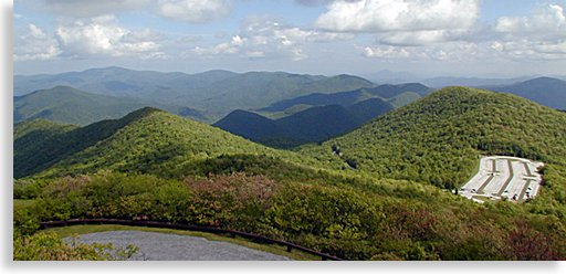
You’re nearing the top when you come in view of the stone tower at the top of Brasstown Bald just up ahead. The roadway passes beside a log cabin gift shop as you enter the huge flat parking lot where the road ends; the bald is 1/2 mile further up. The parking area at Brasstown Bald is an unusual phenomenon; it is a natural large flat area near the top of the mountain, with bookend mountain balds at either end of the parking lot, a smaller one at one end and the large Brasstown Bald at the other.
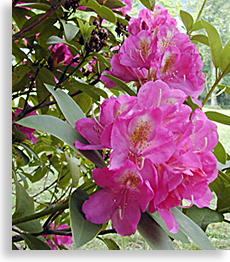 A natural wall of foliage on the west side of the parking area is of white and pink rhododendrons, nearly lining the the entire length of the parking lot in June and July. There is a great view with picnics tables on the right side at the far end of the parking area. This view is a western view of Union County with its large open valley rolled out in front of you with Blood Mountain up front on your left and Duncan Ridge running westward along the southern horizon, the Cohutta Mountains on the far western horizon is in Fannin County Georgia.
There are two ways to access the summit of Brasstown Bald, one by foot up the steep paved 1/2 mile trail, or by a convenient shuttle bus service to the top and back for one modest price. To save time I usually ride up and walk down to get the full experience. The visitor’s center and observation deck looks like a stone fortress above the roadway with a tall stone tower standing on one end. The tower is closed to the public until further notice due to need of restoration; its main purpose was to act as a lookout tower for forest fires. A lower stone and wood balcony offers close to a 360-degree view from the summit’s 4,784 elevation. The upper balcony surrounding the tower offers a full 360-degree mountain view.
The views from North Georgia’s rooftop is of the mountains of the Chattahoochee National Forest to the south and east with views of the great western mountain valley rolling out before your eyes towards the sunset. Glimpses of Lake Nottely’s long channels reflect sun-rays off the water’s surface if your eyes are sharp enough to catch them.
To the north is North Carolina’s Nantahala Mountains and National Forest with summits well surpassing 5,000 feet. In the valley below to the northeast are the sky blue waters of Chatuge Lake which resides in both Towns County Georgia and Clay County North Carolina.
From the balcony you can see the Brasstown Bald parking lot below, many believe this large flat area was here from very early times with legends dating back thousands of years. At 4,784 feet above sea level, Brasstown Bald claims the highest North Georgia Mountain status; Rabun Bald to the east in Rabun County has a recorded elevation of 4,696 feet above sea level as the second highest mountain in North Georgia. Some claim it’s actually taller than Brasstown Bald challenging the title for North Georgia’s tallest natural structure. Although, it’s the central geographical location of Brasstown Bald and its natural large parking space that has made Brasstown Bald the more accessible of these two mega-mountains regardless of height.
The summit of Brasstown Bald is almost completely surrounded by the Brasstown Bald Wilderness with hiking trails leading off in several directions. The Old Wagon Trail leads down the mountain to Young Harris in Towns County. The Arkaquah Trail leads from the bald to the Track Rock Gap Archaeological Area located in a low gap near the valley, both trails are long with the Arkaquah Trail rated difficult. At the Visitor’s Center located at the summit of Brasstown Bald you’ll find the Mountain Top Theater. There's an entertaining and educational film on the evolution and erosion of Brasstown Bald and its neighboring mountains, check it out, it’s time well spent.
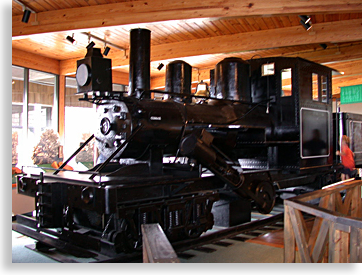 Also located in the Visitor’s Center is a sizable mountaintop museum. Inside the museum there’s a small mountain steam locomotive called the Climax engine which weights 52-tons and was used during the logging era in circa 1913. The coal black engine on display is a replica built to 3/4-scale. Stuffed mountain critters located in the museum tells the story of the wilderness wildlife that live here in the mountains. There are many other displays in the museum offering an insight into the early mountain people’s daily lives both Native American and European descent.
In the museum you'll also find tales from Cherokee and other Native Americans living in the region. The museum offers a few of their legends and myths for visitors to enjoy as well; like the tale of the flying monsters some have referred to as the Thunderbird. Legends tell of these flying beasts with long claws swooping down from the mountaintops and carrying off the Cherokee children. Cherokee hunters located the flying beast living in the heights of the mountaintops, hiding under ledges and cliffs. Unable to reach the cliff dwelling beast, the Cherokee prayed to the Great Spirit who answered with a bolt of lightning destroying the flying monsters and their habitats, and in doing so created these unprotected mountain balds, promising no safe haven for these large flying beasts of prey.
Another interesting legend concerning the bald is located on a plaque at the intersections of GA 180 and State 17/75 in Towns County. Here in a roadway gap on the eastern end of Brasstown Bald and the western edge of Tray Mountain is a brass plaque that tells another Cherokee tale. Legend and myth has it that there was a time of a Great Flood when all the people perished except for a few Cherokee who road out the storm in a giant canoe, landing atop Brasstown Bald known to them as Mount Enotah. The Great Spirit destroyed the trees atop the bald so the survivors could plant crops and live until the floods subsided.
A unique festival occasionally takes place on this magnificent mountain bald and is a must see if your visiting Brasstown Bald during the summer months, it's called the Cool Mountain Festival. Music and dancing, mountain arts and crafts along with displays of early mountain life and customs come alive atop Brasstown Bald.
A special visit from that gentle giant known as Smoky the Bear is known to occur during the Cool Mountain Festival. His presence is not only well received by both adults and children, Smoky is also known to dance a little with the guests.
For more info on this mountain affair check out the Highlander Calendar of Events or contact the Brasstown Bald Ranger District in Blairsville for more information on this special event.
One more feature on the Highlander Union County Scenic Road Trip lies to the north along the lower Brasstown Bald mountain slope in a low mountain gap, the Track Rock Archaeological Site.
Brasstown Bald to Track Rock Gap: Exiting the parking area you leave Brasstown Bald behind slowly descending the mountain road, again it's best to use a lower gear to save on brakes pads. Back at GA 180 turn right and go about 4-miles to Towns Creek School Road and turn right.
Travel about 2-miles to Trackrock Church Road and turn right again. When Trackrock Church Road comes to an end, turn right onto Trackrock Gap Road. Within 1/2 mile up the road there will be a no-frills parking area on the left, park and follow the trail to the right.
 The archaeological site is just a short distance along the roadside. This archaeological site’s natural location along the roadway is very significant. This original pathway over the Trackrock Gap has thought to have been consistently used for over 10,000-years. Large undisturbed soapstone boulders containing numerous ancient petroglyphs, displays a type of crude early Native American writings, with hieroglyphics telling a story not even the Cherokee people can explain.
Trackrock Gap has acted as an important trade route from the earliest times. These writing in stone are regarded by some as nothing more than graffiti while others believe there only the tip of the iceberg concerning an ancient mystery, telling a tale beyond our imaginations. Some of the carvings have been defaced or removed entirely from the archaeological site, causing the Forest Service to install metal cages around the largest and most elaborately carved stone for its protection. Ten thousand years of erosion have soften these writings that consist of symbols and images that mostly defy explanation. Studying this ancient puzzle of the petroglyphs might reveal some of their mysteries for those with an open mind.
The Trackrock Archaeological Site is a story that the Blue Ridge Highlander plans on examining in more depth for its Mountain Mysteries features; you’ll want to check back for that tale.
Leaving this mystery rock gap and its strange stone secret messages behind, continue north on Trackrock Gap Road and you’ll soon reach the end of Trackrock Gap Road at US 76/ State 515, turn left heading westward. A short drive will lead you back to Blairsville and highway 515 ending our Blue Ridge Highlander Scenic Tour of Union County. If you choose to take this driving tour plan it for a full day trip.
Overview of Union County Georgia
Blairsville Georgia, the County Seat
Township of Suches Georgia
Wilderness Areas & Trails
Appalachian Trail Access
Blood Mountain Wilderness
Brasstown Bald & Wilderness
Brasstown Bald Trails
Chattahoochee National Forest
Cooper's Creek Wilderness
Cooper's Creek Wilderness Trails
Duncan Ridge Trails
Community Resources
Farmers Market & Cannery
Butternut Creek Golf Course & Community Center
University of Georgia Department of Agriculture Mountain Research and Educational Center
History & Culture
Byron Herbert Reece Farm and Heritage Center
Trackrock Archaeological Site
Union County Georgia History
Union County Historical Society & Museum
Lakes, Rivers & Waterfalls
Lake Nottely • Lake Trahlyta • Lake Windfield Scott • Dockery Lake
Nottely River
Parks & Recreation Areas
Meeks Park & Trails
Vogel State Park & Trails
Waterfalls
Scenic Road Trips
Gold City Tour
Russell Brasstown Scenic Byway
Other Union County Scenic Road Trips
Union County Farmers Market in Blairsville GA • Every Tues & Sat ~ June through October

The Union County Farmers Market has over 60 covered vendor spaces in our outdoor setting.
148 Old Smokey Rd • Blairsville, GA • 706.439.6000 • CCFarmersMarket.com
Cuddle Up Cabin Rentals, Managing Privately Owned Cabins
224 Blue Ridge Dr • McCaysville, GA • 877.628.3353 • www.CuddleUpCabinRentals.com
Highlander Fine Arts, Authentic Mountain Photography and Fine Crafts
Here are a sampling of the artists you will find....Anthony Abreu • Michael Bedoian • Don Milsaps • Don Blackwell • Juanita Greenspan • Tonya Fowler • Jason Fowler • Mike Lalone • Les Smith • Chuck Waldroup • Joe Waldroup • Billy Reynolds • David Hobby • Randy Rowe • Thomas Payne • Frances McCord • Rita Poole • Clive Poole
Wednesday - Saturday 11'ish - 5'ish
10079 Old Highway 64 • Brasstown, NC • 828.835.9982 • www.HighlanderGallery.com
Great Mountain Properties & Cabin Rentals in now accepting additional cabins
Whether you purchased your mountain home as an occasional getaway, an investment, or the destination of your future retirement, we realize the importance that it be respected as your home first and foremost.
It is our objective to provide you with both quality property management as well as a rental program to help offset some of the expense of owning a 2nd home. Through the combined knowledge of all of us at Great Mountain Cabin Rentals, we have the expertise to help you understand and create a Great Mountain Cabin Rental.
896 Green Cove Road • Brasstown, NC 28902 • 828.835.3275 • www.GreatMountainCabinRentals.com
Trout Treks • Bass Fishing • Wade • Pan Fishing • Fly Fishing • Private Trophy Trout Waters • Drift Boat Trips
So much water to choose from and an adventure you'll never forget.
Call today to start your adventure...828-835-3275 • GreatMountainFishing.com
Rafting on the Ocoee River
Professional river outfitter with over 30 years experience. Our safety record is unsurpassed in the industry. We believe our staff is simply the best in the business. Guides are chosen for their character and enthusiasm for sharing the outdoors with you.
Call today to start your adventure...828-835-3275 • GreatMtnAdventures.com
Rafting on the Nantahala River
Call today to start your adventure...828-835-3275 • GreatMtnAdventures.com
Zip Line Canopy Tours...Nantahala Gorge • Chattooga Ridge • Asheville • Pigeon River
Whichever course you choose you are sure to enjoy the newest outdoor adventure to hit the US.
Call today to start your adventure...828-835-3275 • GreatMtnAdventures.com
Adventure Camp on the Ocoee & Nantahala Rivers
Catch the surge and ride the rapids on the exciting Ocoee River in Tennessee or North Carolina's Nantahala River for an experience you won't forget. Challenge your skills on the high ropes just for the thrill. Sit tall in the saddle for a leisure ride through the beautiful scenery of the Blue Ridge Mountains. Camp out or stay in log cabins while letting the kids sleep in groups in one of several bunkhouse's. We will help you create a custom retreat for you or your group.
tara@greatmountainretreats.com • 828.835.3275 • GreatYouthRetreats.com
Tim Noland, Realtor® - Buyer's Agent • North Georgia & Western North Carolina
When looking to buy mountain property, you need someone that not only understands the mountains, you need someone that specifically represents you, the buyer. When you choose to work with a Buyer's Agent you are assured that you have an agent that is truly looking for your best interests, someone that will not only find what you are looking for, but someone that will negotiate the best price possible.
10886 Old Highway 64 • Brasstown, NC 28902 • 828.557.1009 • GreatMtnRealEstate.com
Keri Conner, Realtor/Broker
224 Blue Ridge Drive, McCaysville, GA • 706-964-6470 • RealEstateGeorgiaMountains.com


The Blue Ridge Highlander logo, all photography, design, graphics, artwork, writing, digital images, etc are the Copyright © of C. Wayne Dukes and Sherry Bell Dukes, 1996 to current day, except where otherwise stated. All rights reserved, reproduction, downloading, and/or duplication of any sort is strictly prohibited, all violations will be prosecuted. Legal Policy. If you have any questions, or comments, regarding this site, e-mail the Highlander.